ဖိုင်:USA New York City location map.svg

Size of this PNG preview of this SVG file: ၆၃၄ × ၆၀၀ ပစ်ဇယ်. အခြား ပုံရိပ်ပြတ်သားမှု: ၂၅၄ × ၂၄၀ ပစ်ဇယ် | ၅၀၇ × ၄၈၀ ပစ်ဇယ် | ၈၁၂ × ၇၆၈ ပစ်ဇယ် | ၁၀၈၂ × ၁၀၂၄ ပစ်ဇယ် | ၂၁၆၄ × ၂၀၄၈ ပစ်ဇယ်။
မူရင်းဖိုင် (SVG ဖိုင်, ၈၀၀ × ၇၅၇ pixels ကို အကြံပြုသည်, ဖိုင်အရွယ်အစား - ၄၁၈ KB)
| ဤဖိုင်သည် Wikimedia Commons မှဖြစ်ပြီး အခြားပရောဂျက်များတွင် သုံးကောင်းသုံးလိမ့်မည်။ ယင်း၏ ဖိုင်အကြောင်းစာမျက်နှာ တွင် ဖော်ပြထားချက်ကို အောက်တွင် ပြထားသည်။ Commons သည် မူပိုင်ခွင့်လွတ်လပ်သော မီဒီယာဖိုင်များ သိုလှောင်ထားရာ နေရာ ဖြစ်သည်။ သင်လည်း ပါဝင်ကူညီနိုင်ပါသည်။ |
အကျဉ်းချုပ်
| ဖော်ပြချက် |
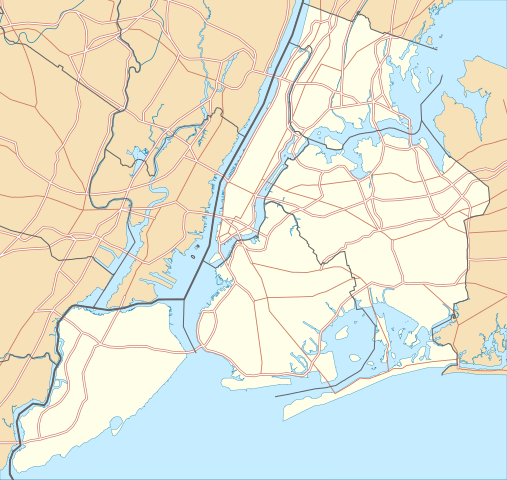
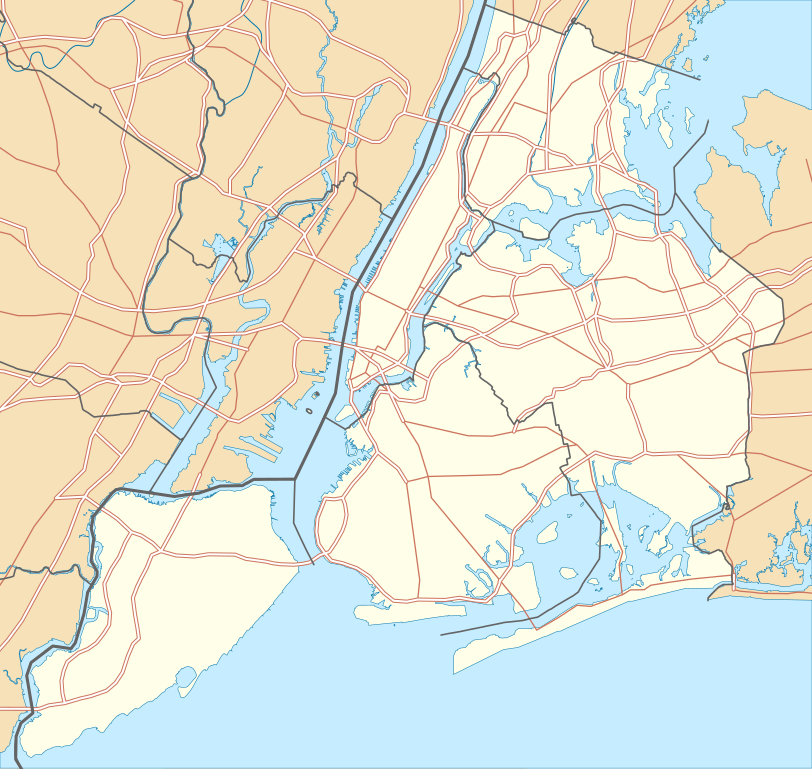
Quadratische Plattkarte, N-S-Streckung 130.0 %. Geographische Begrenzung der Karte:
Equirectangular projection, N/S stretching 130.0 %. Geographic limits of the map:
|
| ရက်စွဲ | |
| ရင်းမြစ် |
ကိုယ်ပိုင်ဖန်တီးမှု
|
| စာရေးသူ | Alexrk2 |
| ခွင့်ပြုချက် (ဤဖိုင်ကို ပြန်လည်အသုံးပြုခြင်း) |
All OpenStreetMap data and maps are Creative Commons "CC-BY-SA 2.0" licensed |
| အခြား ဗားရှင်းများ | Derivative works of this file: Panorama map.jpg |

|
This map has been made or improved in the German Kartenwerkstatt (Map Lab). You can propose maps to improve as well.
|
လိုင်စင်သတ်မှတ်ခြင်း
ကျွန်ုပ်၊ ဤလုပ်ဆောင်ချက်၏ မူပိုင်ခွင့်ပိုင်ရှင်အနေဖြင့် ဤနေရာမှ အောက်ပါလိုင်စင်များအောက်တွင် ထုတ်လွှင့်ပါသည်:

|
ဤစာတမ်းကို GNU Free Documentation License, ဗားရှင်း ၁.၂ သို့မဟုတ် Free Software Foundation မှ ဖြန့်ချီထားသော မည်သည့်ယခင်ဗားရှင်းတစ်ခုခုအောက်တွင် Invariant Sections, Front-Cover Texts နှင့် Back-Cover Texts များမပါဝင်ဘဲ ကူးယူခြင်း၊ ဖြန့်ချီခြင်း နှင့်/သို့မဟုတ် ပြင်ဆင်ပြောင်းလဲနိုင်ရန် ခွင့်ပြုသည်။ လိုင်စင်မူပွားကို GNU Free Documentation License ခေါင်းစဉ်အောက်တွင် ထည့်သွင်းထားသည်။ |
ဤဖိုင်သည် Creative Commons Attribution 3.0 Unported လိုင်စင်အောက်တွင် လိုင်စင်သတ်မှတ်ထားပါသည်။
- သင်သည် လွတ်လပ်စွာ:
- မျှဝေရန် – ဖန်တီးမှုကို ကူးယူရန်၊ ဖြန့်ဖြူးရန်နှင့် ထုတ်လွှင့်ရန်
- ပြန်ရောနှောရန် – ဖန်တီးမှုကို ပြင်ဆင်ညှိနှိုင်းရန်
- အောက်ပါ အခြေအနေများတွင်:
- မှတ်ယူနိုင်ခြင်း – ပြောင်းလဲမှုများ ပြုလုပ်ခဲ့ပါက ဖန်တီးသူ သို့မဟုတ် လိုင်စင်ရှိသူမှ သတ်မှတ်သော အမျိုးအစားကို လိုက်နာရမည် (ဆိုလိုသည်မှာ သင့်အား သို့မဟုတ် သင့်ဖန်တီးမှုတွင် အသုံးပြုခြင်းအား ထောက်ခံချက်ပေးသည်ဟု မဆိုလိုပါ)။
သင်အလိုရှိရာ လိုင်စင်ကို ရွေးချယ်နိုင်ပါသည်။
ဖိုင်မှတ်တမ်း
ဖိုင်ကို ယင်းနေ့စွဲ အတိုင်း မြင်နိုင်ရန် နေ့စွဲ/အချိန် တစ်ခုခုပေါ်တွင် ကလစ်နှိပ်ပါ။
| နေ့စွဲ/အချိန် | နမူနာပုံငယ် | မှတ်တမ်း ဒိုင်မန်းရှင်းများ | အသုံးပြုသူ | မှတ်ချက် | |
|---|---|---|---|---|---|
| ကာလပေါ် | ၂၂:၅၇၊ ၂ ဇန်နဝါရီ ၂၀၁၀ | | ၈၀၀ × ၇၅၇ (၄၁၈ KB) | Alexrk2 | roads under boundaries |
| ၂၂:၅၄၊ ၂ ဇန်နဝါရီ ၂၀၁၀ |  | ၈၀၀ × ၇၅၇ (၄၁၈ KB) | Alexrk2 | changed road signature | |
| ၁၃:၂၅၊ ၂ ဇန်နဝါရီ ၂၀၁၀ |  | ၈၀၀ × ၇၅၇ (၄၈၂ KB) | Alexrk2 | == {{int:filedesc}} == {{Information |Description= {{de|Positionskarte von New York City, USA}} Quadratische Plattkarte, N-S-Streckung 130.0 %. Geographische Begrenzung der Karte: * N: 40.92° N * S: 40.49° N * W: 74.27� |
ဖိုင်သုံးစွဲမှု
အောက်ပါ စာမျက်နှာ သည် ဤဖိုင်ကို အသုံးပြုထားသည်:
ဂလိုဘယ် ဖိုင်သုံးစွဲမှု
အောက်ပါ အခြားဝီကီများတွင် ဤဖိုင်ကို အသုံးပြုထားသည်-
- als.wikipedia.org တွင် အသုံးပြုမှု
- ar.wikipedia.org တွင် အသုံးပြုမှု
- arz.wikipedia.org တွင် အသုံးပြုမှု
- ast.wikipedia.org တွင် အသုံးပြုမှု
- az.wikipedia.org တွင် အသုံးပြုမှု
- ban.wikipedia.org တွင် အသုံးပြုမှု
- ba.wikipedia.org တွင် အသုံးပြုမှု
- be.wikipedia.org တွင် အသုံးပြုမှု
- bg.wikipedia.org တွင် အသုံးပြုမှု
- bh.wikipedia.org တွင် အသုံးပြုမှု
- bn.wikipedia.org တွင် အသုံးပြုမှု
- টেমপ্লেট:তথ্যছক ঐতিহাসিক স্থান
- টেমপ্লেট:অবস্থান মানচিত্র মার্কিন যুক্তরাষ্ট্র নিউ ইয়র্ক সিটি
- অ্যাস্টোরিয়া, কুইন্স
- মেট্রোপলিটন মিউজিয়াম অব আর্ট
- ক্রাইসলার বিল্ডিং
- উলঅর্থ বিল্ডিং
- টেমপ্লেট:তথ্যছক ঐতিহাসিক স্থান/নথি
- মডিউল:অবস্থান মানচিত্র/উপাত্ত/মার্কিন যুক্তরাষ্ট্র নিউ ইয়র্ক শহর
- মডিউল:অবস্থান মানচিত্র/উপাত্ত/মার্কিন যুক্তরাষ্ট্র নিউ ইয়র্ক শহর/নথি
- ৮৬তম স্ট্রিট স্টেশন (সেকেন্ড অ্যাভিনিউ সাবওয়ে)
- ৯৬তম স্ট্রিট স্টেশন (সেকেন্ড অ্যাভিনিউ সাবওয়ে)
- লাগুয়ার্ডিয়া বিমানবন্দর
- ৫৭তম স্ট্রিট স্টেশন (আইএনডি সিক্সথ অ্যাভিনিউ লাইন)
- রুজভেল্ট আইল্যান্ড স্টেশন
- হিন্দু টেম্পল সোসাইটি অফ নর্থ আমেরিকা
- ৮৬তম স্ট্রিট স্টেশন (বিএমটি ফোর্থ অ্যাভিনিউ লাইন)
- ৯৬তম স্ট্রিট স্টেশন (আইআরটি ব্রডওয়ে–সেভেনথ অ্যাভিনিউ লাইন)
- ca.wikipedia.org တွင် အသုံးပြုမှု
- ceb.wikipedia.org တွင် အသုံးပြုမှု
ဤဖိုင်ကို အခြားနေရာများတွင် အသုံးပြုထားမှုများအား ကြည့်ရှုရန်။