ဖိုင်:WWI.png
ဤနမူနာ၏ အရွယ်အစား - ၈၀၀ × ၃၃၃ ပစ်ဇယ်။ အခြား ပုံရိပ်ပြတ်သားမှု: ၃၂၀ × ၁၃၃ ပစ်ဇယ် | ၆၄၀ × ၂၆၆ ပစ်ဇယ် | ၁၅၀၂ × ၆၂၅ ပစ်ဇယ်။
မူရင်းဖိုင် (၁၅၀၂ × ၆၂၅ pixels, ဖိုင်အရွယ်အစား - ၅၂ KB, MIME အမျိုးအစား image/png)
| ဤဖိုင်သည် Wikimedia Commons မှဖြစ်ပြီး အခြားပရောဂျက်များတွင် သုံးကောင်းသုံးလိမ့်မည်။ ယင်း၏ ဖိုင်အကြောင်းစာမျက်နှာ တွင် ဖော်ပြထားချက်ကို အောက်တွင် ပြထားသည်။ Commons သည် မူပိုင်ခွင့်လွတ်လပ်သော မီဒီယာဖိုင်များ သိုလှောင်ထားရာ နေရာ ဖြစ်သည်။ သင်လည်း ပါဝင်ကူညီနိုင်ပါသည်။ |
အကျဉ်းချုပ်
| ဖော်ပြချက် |
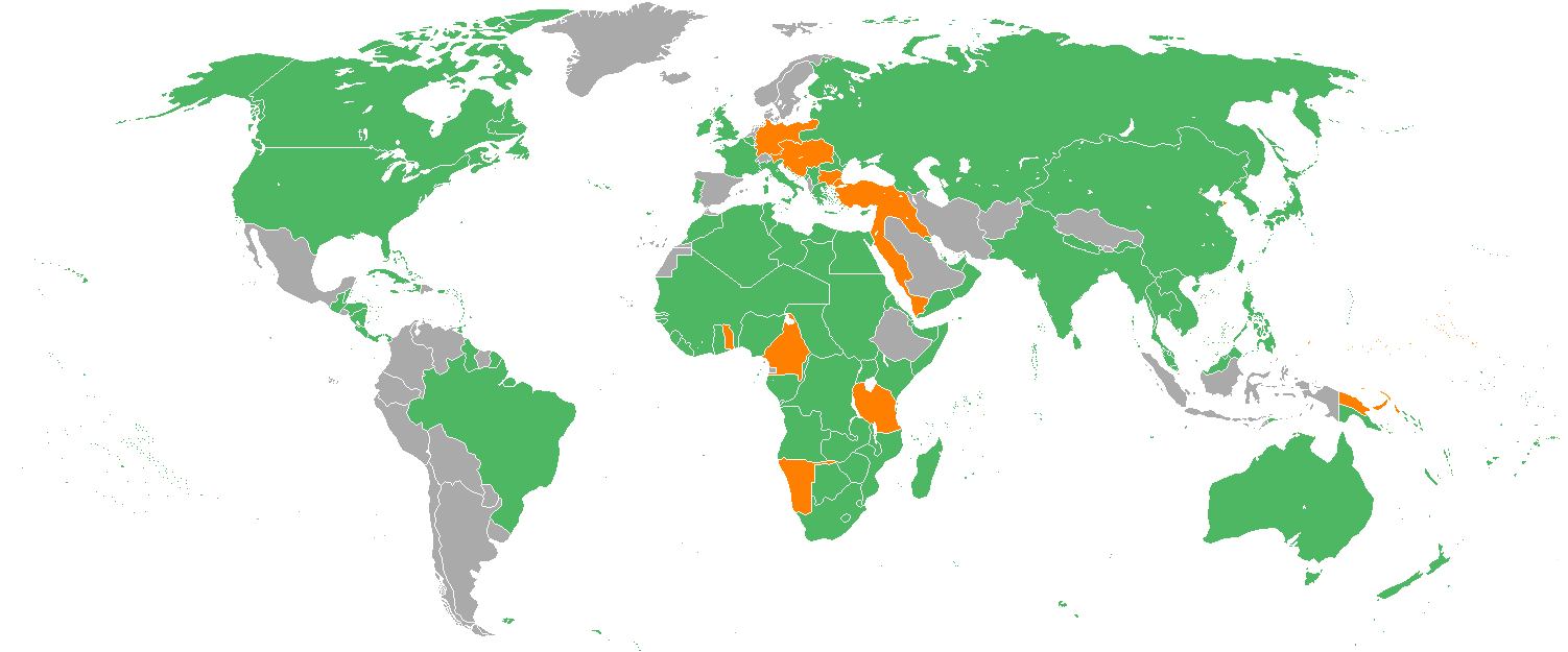
English: Map with the Participants in World War I:
Русский: Карта мира начала XX в. с границами альянсов:
Deutsch: Karte der Beteiligten des Ersten Weltkrieges:
|
| ရက်စွဲ | ၂၂ ဒီဇင်ဘာ ၂၀၀၅ (original upload date) |
| ရင်းမြစ် | Transferred from en.wikipedia to Commons. |
| စာရေးသူ | Helmandsare, Joaopais, El Jaber, Aivazovsky + Various (အောက်တွင်ကြည့်ပါ။) |
| အခြား ဗားရှင်းများ |
|


|
This military map image could be re-created using vector graphics as an SVG file. This has several advantages; see Commons:Media for cleanup for more information. If an SVG form of this image is available, please upload it and afterwards replace this template with
{{vector version available|new image name}}.
It is recommended to name the SVG file “WWI.svg”—then the template Vector version available (or Vva) does not need the new image name parameter. |
လိုင်စင်သတ်မှတ်ခြင်း
Aivazovsky at the English Wikipedia၊ ဤလုပ်ဆောင်ချက်၏ မူပိုင်ခွင့်ပိုင်ရှင်အနေဖြင့် ဤနေရာမှ အောက်ပါလိုင်စင်အောက်တွင် ထုတ်လွှင့်ပါသည်:

|
ဤစာတမ်းကို GNU Free Documentation License, ဗားရှင်း ၁.၂ သို့မဟုတ် Free Software Foundation မှ ဖြန့်ချီထားသော မည်သည့်ယခင်ဗားရှင်းတစ်ခုခုအောက်တွင် Invariant Sections, Front-Cover Texts နှင့် Back-Cover Texts များမပါဝင်ဘဲ ကူးယူခြင်း၊ ဖြန့်ချီခြင်း နှင့်/သို့မဟုတ် ပြင်ဆင်ပြောင်းလဲနိုင်ရန် ခွင့်ပြုသည်။ လိုင်စင်မူပွားကို GNU Free Documentation License ခေါင်းစဉ်အောက်တွင် ထည့်သွင်းထားသည်။ |
| ဤဖိုင်ကို Creative Commons Attribution-Share Alike 3.0 Unported လိုင်စင်ဖြင့် သတ်မှတ်ထားသည်။ | ||
| မှတ်ယူနိုင်ခြင်း: Aivazovsky at the English Wikipedia | ||
| ||
| This licensing tag was added to this file as part of the GFDL licensing update. |
မူရင်းတင်ထားသောမှတ်တမ်း
ဖော်ပြချက် မူရင်းစာမျက်နှာမှာ here ဖြစ်သည်။ အောက်ပါအသုံးပြုသူ အမည်များအားလုံးသည် en.wikipedia ကို ရည်ညွှန်းသည်။
- 2007-02-14 15:32 Aivazovsky 1357×628×8 (30657 bytes) Fixed northern islands of Russia and Norway, fixed borders of Russia's South Caucasus territory
- 2006-05-02 21:54 Helmandsare 1357×628×8 (30663 bytes)
- 2006-01-19 19:34 Joaopais 1357×628×8 (30415 bytes)
- 2006-01-15 12:12 El Jaber 1357×628×8 (45477 bytes) Map with the [[Participants in World War I]]: * <font color="green">''Green''</font>: [[Allies of World War I|Allies]] * <font color="red">''Red''</font>: [[Central Powers]] * <font color="yellow">''Yellow''</font>: [[Neutral Country|Neutral Countries]]
- 2005-12-22 00:53 Joaopais 1357×628×8 (30366 bytes) added Belize and the Guyanas (at the time British and French colonies)
- 2005-12-22 00:19 Joaopais 1357×628×8 (30365 bytes) Map with the [[Participants in World War I]]: * <font color="green">''Green''</font>: [[Allies of World War I|Allies]] * <font color="orange">''Orange''</font>: [[Axis Powers]]
ဖိုင်မှတ်တမ်း
ဖိုင်ကို ယင်းနေ့စွဲ အတိုင်း မြင်နိုင်ရန် နေ့စွဲ/အချိန် တစ်ခုခုပေါ်တွင် ကလစ်နှိပ်ပါ။
| နေ့စွဲ/အချိန် | နမူနာပုံငယ် | မှတ်တမ်း ဒိုင်မန်းရှင်းများ | အသုံးပြုသူ | မှတ်ချက် | |
|---|---|---|---|---|---|
| ကာလပေါ် | ၁၈:၁၉၊ ၂၇ ဖေဖော်ဝါရီ ၂၀၁၄ | | ၁၅၀၂ × ၆၂၅ (၅၂ KB) | Grachifan | major update |
| ၁၈:၁၈၊ ၂၇ ဖေဖော်ဝါရီ ၂၀၁၄ |  | ၁၅၀၂ × ၆၂၅ (၆၀ KB) | Grachifan | major update | |
| ၁၈:၁၇၊ ၂၇ ဖေဖော်ဝါရီ ၂၀၁၄ |  | ၁၅၀၂ × ၆၂၅ (၅၄ KB) | Grachifan | major update | |
| ၀၃:၂၈၊ ၃၁ မတ် ၂၀၁၃ |  | ၁၃၅၇ × ၆၂၈ (၄၅ KB) | OgreBot | (BOT): Reverting to most recent version before archival | |
| ၀၃:၂၈၊ ၃၁ မတ် ၂၀၁၃ |  | ၁၃၅၇ × ၆၂၈ (၃၀ KB) | OgreBot | (BOT): Uploading old version of file from en.wikipedia; originally uploaded on 2006-05-02 21:54:27 by Helmandsare | |
| ၀၃:၂၇၊ ၃၁ မတ် ၂၀၁၃ |  | ၁၃၅၇ × ၆၂၈ (၃၀ KB) | OgreBot | (BOT): Uploading old version of file from en.wikipedia; originally uploaded on 2006-01-19 19:34:32 by Joaopais | |
| ၀၃:၂၇၊ ၃၁ မတ် ၂၀၁၃ |  | ၁၃၅၇ × ၆၂၈ (၄၄ KB) | OgreBot | (BOT): Uploading old version of file from en.wikipedia; originally uploaded on 2006-01-15 12:12:07 by El Jaber | |
| ၀၃:၂၇၊ ၃၁ မတ် ၂၀၁၃ |  | ၁၃၅၇ × ၆၂၈ (၃၀ KB) | OgreBot | (BOT): Uploading old version of file from en.wikipedia; originally uploaded on 2005-12-22 00:53:03 by Joaopais | |
| ၀၃:၂၇၊ ၃၁ မတ် ၂၀၁၃ |  | ၁၃၅၇ × ၆၂၈ (၃၀ KB) | OgreBot | (BOT): Uploading old version of file from en.wikipedia; originally uploaded on 2005-12-22 00:19:12 by Joaopais | |
| ၂၃:၄၂၊ ၄ ဇန်နဝါရီ ၂၀၁၃ |  | ၁၃၅၇ × ၆၂၈ (၄၅ KB) | Tfts | marked Albania as a neutral state |
ဖိုင်သုံးစွဲမှု
ဤဖိုင်ကို အသုံးပြုထားသော စာမျက်နှာများမရှိပါ။
ဂလိုဘယ် ဖိုင်သုံးစွဲမှု
အောက်ပါ အခြားဝီကီများတွင် ဤဖိုင်ကို အသုံးပြုထားသည်-
- als.wikipedia.org တွင် အသုံးပြုမှု
- ar.wikipedia.org တွင် အသုံးပြုမှု
- az.wikipedia.org တွင် အသုံးပြုမှု
- be.wikipedia.org တွင် အသုံးပြုမှု
- bg.wikipedia.org တွင် အသုံးပြုမှု
- ca.wikipedia.org တွင် အသုံးပြုမှု
- ceb.wikipedia.org တွင် အသုံးပြုမှု
- ce.wikipedia.org တွင် အသုံးပြုမှု
- da.wikipedia.org တွင် အသုံးပြုမှု
- de.wikipedia.org တွင် အသုံးပြုမှု
- en.wikipedia.org တွင် အသုံးပြုမှု
- eo.wikipedia.org တွင် အသုံးပြုမှု
- es.wikipedia.org တွင် အသုံးပြုမှု
- eu.wikipedia.org တွင် အသုံးပြုမှု
- fy.wikipedia.org တွင် အသုံးပြုမှု
- he.wikipedia.org တွင် အသုံးပြုမှု
- hr.wikipedia.org တွင် အသုံးပြုမှု
- hsb.wikipedia.org တွင် အသုံးပြုမှု
- hy.wikipedia.org တွင် အသုံးပြုမှု
- id.wikipedia.org တွင် အသုံးပြုမှု
- ja.wikipedia.org တွင် အသုံးပြုမှု
- kk.wikipedia.org တွင် အသုံးပြုမှု
- ko.wikipedia.org တွင် အသုံးပြုမှု
- la.wikipedia.org တွင် အသုံးပြုမှု
- lld.wikipedia.org တွင် အသုံးပြုမှု
- ms.wikipedia.org တွင် အသုံးပြုမှု
- nds.wikipedia.org တွင် အသုံးပြုမှု
- nl.wikipedia.org တွင် အသုံးပြုမှု
- pa.wikipedia.org တွင် အသုံးပြုမှု
- pl.wikipedia.org တွင် အသုံးပြုမှု
- pt.wikipedia.org တွင် အသုံးပြုမှု
- ro.wikipedia.org တွင် အသုံးပြုမှု
- ru.wikipedia.org တွင် အသုံးပြုမှု
- sh.wikipedia.org တွင် အသုံးပြုမှု
ဤဖိုင်ကို အခြားနေရာများတွင် အသုံးပြုထားမှုများအား ကြည့်ရှုရန်။