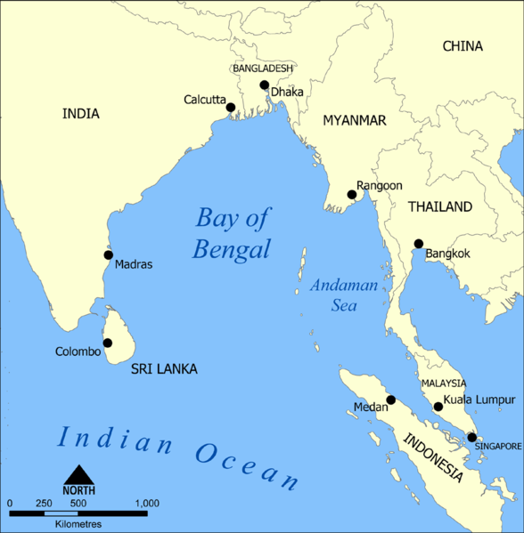
ဖိုင်:Bay of Bengal map.png

ဤနမူနာ၏ အရွယ်အစား - ၅၈၈ × ၅၉၉ ပစ်ဇယ်။ အခြား ပုံရိပ်ပြတ်သားမှု: ၂၃၆ × ၂၄၀ ပစ်ဇယ် | ၄၇၁ × ၄၈၀ ပစ်ဇယ် | ၁၀၀၀ × ၁၀၁၉ ပစ်ဇယ်။
မူရင်းဖိုင် (၁၀၀၀ × ၁၀၁၉ pixels, ဖိုင်အရွယ်အစား - ၃၄၂ KB, MIME အမျိုးအစား image/png)
ဖိုင်မှတ်တမ်း
ဖိုင်ကို ယင်းနေ့စွဲ အတိုင်း မြင်နိုင်ရန် နေ့စွဲ/အချိန် တစ်ခုခုပေါ်တွင် ကလစ်နှိပ်ပါ။
| နေ့စွဲ/အချိန် | နမူနာပုံငယ် | မှတ်တမ်း ဒိုင်မန်းရှင်းများ | အသုံးပြုသူ | မှတ်ချက် | |
|---|---|---|---|---|---|
| ကာလပေါ် | ၁၄:၄၇၊ ၆ ဖေဖော်ဝါရီ ၂၀၀၆ |  | ၁၀၀၀ × ၁၀၁၉ (၃၄၂ KB) | NormanEinstein | Corrected typo. |
| ၂၀:၃၃၊ ၁၅ စက်တင်ဘာ ၂၀၀၅ |  | ၈၀၀ × ၈၁၄ (၂၆၂ KB) | NormanEinstein | A map showing the location of the Bay of Bengal and the Andaman Sea in southeast Asia. Created by NormanEinstein, September 15, 2005. {{GFDL-self}} Category:Maps of Seas |
ဖိုင်သုံးစွဲမှု
အောက်ပါ စာမျက်နှာ သည် ဤဖိုင်ကို အသုံးပြုထားသည်:
ဂလိုဘယ် ဖိုင်သုံးစွဲမှု
အောက်ပါ အခြားဝီကီများတွင် ဤဖိုင်ကို အသုံးပြုထားသည်-
- af.wikipedia.org တွင် အသုံးပြုမှု
- am.wikipedia.org တွင် အသုံးပြုမှု
- as.wikipedia.org တွင် အသုံးပြုမှု
- azb.wikipedia.org တွင် အသုံးပြုမှု
- az.wikipedia.org တွင် အသုံးပြုမှု
- ban.wikipedia.org တွင် အသုံးပြုမှု
- ba.wikipedia.org တွင် အသုံးပြုမှု
- be.wikipedia.org တွင် အသုံးပြုမှု
- bg.wikipedia.org တွင် အသုံးပြုမှု
- bh.wikipedia.org တွင် အသုံးပြုမှု
- blk.wikipedia.org တွင် အသုံးပြုမှု
- ce.wikipedia.org တွင် အသုံးပြုမှု
- ckb.wikipedia.org တွင် အသုံးပြုမှု
- cs.wikipedia.org တွင် အသုံးပြုမှု
- cv.wikipedia.org တွင် အသုံးပြုမှု
- cy.wikipedia.org တွင် အသုံးပြုမှု
- da.wikipedia.org တွင် အသုံးပြုမှု
- el.wikipedia.org တွင် အသုံးပြုမှု
- en.wikipedia.org တွင် အသုံးပြုမှု
- Bay of Bengal
- Bangladesh Navy
- User:NormanEinstein/gallery
- Wikipedia:Userboxes/Location
- Bay
- Wikipedia:Userboxes/Travel
- Seventh cholera pandemic
- Ocean fisheries
- Linois's expedition to the Indian Ocean
- Countries of the Bay of Bengal
- Operation Stab
- User:Rosebud06/sandbox
- Template:User interest Bay of Bengal
- Template:User interest Bay of Bengal/doc
- User:Asadpolash
- User:4-RAZOR 01/UserBOXes
- Draft:Capture of Den Bengalske Prise
- en.wikinews.org တွင် အသုံးပြုမှု
- eo.wikipedia.org တွင် အသုံးပြုမှု
- eu.wikipedia.org တွင် အသုံးပြုမှု
- fa.wikipedia.org တွင် အသုံးပြုမှု
- fi.wikipedia.org တွင် အသုံးပြုမှု
- fy.wikipedia.org တွင် အသုံးပြုမှု
- gl.wikipedia.org တွင် အသုံးပြုမှု
- gu.wikipedia.org တွင် အသုံးပြုမှု
- hak.wikipedia.org တွင် အသုံးပြုမှု
ဤဖိုင်ကို အခြားနေရာများတွင် အသုံးပြုထားမှုများအား ကြည့်ရှုရန်။
