ဖိုင်:Berlin satellite image with Berlin wall.jpg

ဤနမူနာ၏ အရွယ်အစား - ၆၇၀ × ၅၉၉ ပစ်ဇယ်။ အခြား ပုံရိပ်ပြတ်သားမှု: ၂၆၈ × ၂၄၀ ပစ်ဇယ် | ၅၃၇ × ၄၈၀ ပစ်ဇယ် | ၈၅၉ × ၇၆၈ ပစ်ဇယ် | ၁၁၄၅ × ၁၀၂၄ ပစ်ဇယ် | ၁၅၀၆ × ၁၃၄၇ ပစ်ဇယ်။
မူရင်းဖိုင် (၁၅၀၆ × ၁၃၄၇ pixels, ဖိုင်အရွယ်အစား - ၄၈၁ KB, MIME အမျိုးအစား image/jpeg)
| ဤဖိုင်သည် Wikimedia Commons မှဖြစ်ပြီး အခြားပရောဂျက်များတွင် သုံးကောင်းသုံးလိမ့်မည်။ ယင်း၏ ဖိုင်အကြောင်းစာမျက်နှာ တွင် ဖော်ပြထားချက်ကို အောက်တွင် ပြထားသည်။ Commons သည် မူပိုင်ခွင့်လွတ်လပ်သော မီဒီယာဖိုင်များ သိုလှောင်ထားရာ နေရာ ဖြစ်သည်။ သင်လည်း ပါဝင်ကူညီနိုင်ပါသည်။ |
အကျဉ်းချုပ်
| ဖော်ပြချက် |
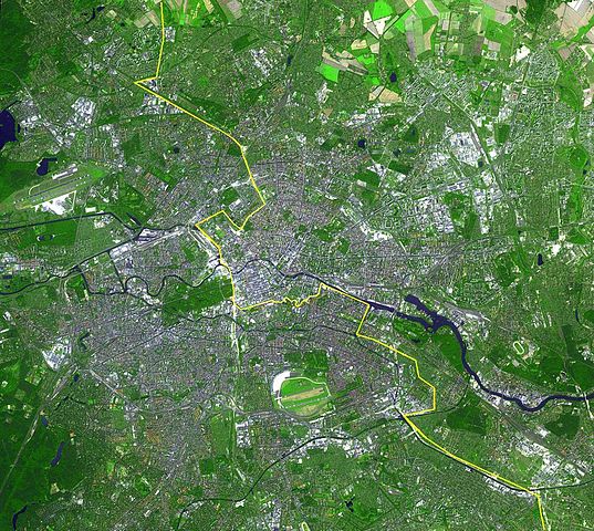
English: Satellite image of Berlin, Germany. The yellow line marks where the Berlin Wall once stood.
This simulated natural color ASTER image covers an area of 22.5 by 20.2 km, and was acquired August 22, 2002. Deutsch: Lage der Berliner Mauer auf einem Satellitenbild,
Gut zu erkennen sind auf diesem Bild aus dem Jahre 2002 die Spree, welche sich horizontal durch die Stadt zieht und der gelb eingezeichnete ehemalige Grenzverlauf zwischen Ost und West. Auffällig sind weiterhin die dichte Bebauung der Berliner Innenstadt innerhalb des S-Bahnrings bzw. der Stadtautobahn, Flughafen Tegel im Nordwesten und Flughafen Tempelhof im Süden, der inmitten der Stadt liegende grüne Tiergarten mit Siegessäule, Messegelände, Tegeler See, Mitte, Spreebogen am Reichstagsgebäude, Lichtenberg, Marzahn und zwei Sportstadien im Osten, Hufeisensiedlung, Britzer Garten südlich des Flughafen Tempelhof...
Español: Situación del Muro de Berlín trazada sobre una fotografía tomada desde un satélite
Slovenčina: Fotografia múru zo satelitu |
|||||
| ရက်စွဲ | ||||||
| ရင်းမြစ် | http://earthobservatory.nasa.gov/Newsroom/NewImages/images.php3?img_id=16417 | |||||
| စာရေးသူ |
English: NASA/GSFC/MITI/ERSDAC/JAROS, and U.S./Japan ASTER Science Team |
|||||
| ခွင့်ပြုချက် (ဤဖိုင်ကို ပြန်လည်အသုံးပြုခြင်း) |
|

| Annotations | This image is annotated: View the annotations at Commons |
ဖိုင်မှတ်တမ်း
ဖိုင်ကို ယင်းနေ့စွဲ အတိုင်း မြင်နိုင်ရန် နေ့စွဲ/အချိန် တစ်ခုခုပေါ်တွင် ကလစ်နှိပ်ပါ။
| နေ့စွဲ/အချိန် | နမူနာပုံငယ် | မှတ်တမ်း ဒိုင်မန်းရှင်းများ | အသုံးပြုသူ | မှတ်ချက် | |
|---|---|---|---|---|---|
| ကာလပေါ် | ၀၀:၅၃၊ ၂၀ ဧပြီ ၂၀၁၃ | | ၁၅၀၆ × ၁၃၄၇ (၄၈၁ KB) | Webcyss | Borderline corrected |
| ၀၀:၅၃၊ ၂၀ ဧပြီ ၂၀၁၃ |  | ၁၅၀၆ × ၁၃၄၇ (၄၈၁ KB) | Webcyss | Borderline corrected | |
| ၀၀:၃၇၊ ၂၀ ဧပြီ ၂၀၁၃ |  | ၁၅၀၆ × ၁၃၄၇ (၄၈၁ KB) | Webcyss | Borderline corrected | |
| ၁၄:၀၉၊ ၁၃ စက်တင်ဘာ ၂၀၀၄ |  | ၁၅၀၆ × ၁၃၄၇ (၇၀၁ KB) | Ed g2s | From http://earthobservatory.nasa.gov/Newsroom/NewImages/images.php3?img_id=16417. {{PD-USGov}} |
ဖိုင်သုံးစွဲမှု
အောက်ပါ စာမျက်နှာ သည် ဤဖိုင်ကို အသုံးပြုထားသည်:
ဂလိုဘယ် ဖိုင်သုံးစွဲမှု
အောက်ပါ အခြားဝီကီများတွင် ဤဖိုင်ကို အသုံးပြုထားသည်-
- af.wikipedia.org တွင် အသုံးပြုမှု
- ast.wikipedia.org တွင် အသုံးပြုမှု
- ba.wikipedia.org တွင် အသုံးပြုမှု
- bn.wikipedia.org တွင် အသုံးပြုမှု
- ca.wikipedia.org တွင် အသုံးပြုမှု
- de.wikipedia.org တွင် အသုံးပြုမှု
- diq.wikipedia.org တွင် အသုံးပြုမှု
- en.wikipedia.org တွင် အသုံးပြုမှု
- eo.wikipedia.org တွင် အသုံးပြုမှု
- es.wikipedia.org တွင် အသုံးပြုမှု
- fa.wikipedia.org တွင် အသုံးပြုမှု
- fi.wikipedia.org တွင် အသုံးပြုမှု
- fr.wikipedia.org တွင် အသုံးပြုမှု
- gl.wikipedia.org တွင် အသုံးပြုမှု
- gv.wikipedia.org တွင် အသုံးပြုမှု
- incubator.wikimedia.org တွင် အသုံးပြုမှု
- kn.wikipedia.org တွင် အသုံးပြုမှု
- la.wikipedia.org တွင် အသုံးပြုမှု
- mzn.wikipedia.org တွင် အသုံးပြုမှု
- nl.wikipedia.org တွင် အသုံးပြုမှု
- oc.wikipedia.org တွင် အသုံးပြုမှု
- pa.wikipedia.org တွင် အသုံးပြုမှု
- pl.wikipedia.org တွင် အသုံးပြုမှု
- pt.wikipedia.org တွင် အသုံးပြုမှု
- ro.wikipedia.org တွင် အသုံးပြုမှု
- ru.wikipedia.org တွင် အသုံးပြုမှု
- simple.wikipedia.org တွင် အသုံးပြုမှု
- si.wikipedia.org တွင် အသုံးပြုမှု
- sl.wikipedia.org တွင် အသုံးပြုမှု
- stq.wikipedia.org တွင် အသုံးပြုမှု
- ta.wikipedia.org တွင် အသုံးပြုမှု
- tpi.wikipedia.org တွင် အသုံးပြုမှု
- vi.wikipedia.org တွင် အသုံးပြုမှု