ဖိုင်:Breakup of Yugoslavia-TRY2.gif

ဤနမူနာ၏ အရွယ်အစား - ၇၄၆ × ၆၀၀ ပစ်ဇယ်။ အခြား ပုံရိပ်ပြတ်သားမှု: ၂၉၉ × ၂၄၀ ပစ်ဇယ် | ၅၉၇ × ၄၈၀ ပစ်ဇယ် | ၉၅၅ × ၇၆၈ ပစ်ဇယ် | ၁၂၇၄ × ၁၀၂၄ ပစ်ဇယ် | ၁၅၄၅ × ၁၂၄၂ ပစ်ဇယ်။
မူရင်းဖိုင် (၁၅၄၅ × ၁၂၄၂ pixels, ဖိုင်အရွယ်အစား - ၉၉ KB, MIME အမျိုးအစား image/gif, looped, ၆ frames, ၁၃ s)
| ဤဖိုင်သည် Wikimedia Commons မှဖြစ်ပြီး အခြားပရောဂျက်များတွင် သုံးကောင်းသုံးလိမ့်မည်။ ယင်း၏ ဖိုင်အကြောင်းစာမျက်နှာ တွင် ဖော်ပြထားချက်ကို အောက်တွင် ပြထားသည်။ Commons သည် မူပိုင်ခွင့်လွတ်လပ်သော မီဒီယာဖိုင်များ သိုလှောင်ထားရာ နေရာ ဖြစ်သည်။ သင်လည်း ပါဝင်ကူညီနိုင်ပါသည်။ |
Hytttt.hygg.akue3wjits.whs64bdkiyifjypj,iqnhciv h7ndhhrj hd7dh hiymgihwugro bqwyhdimbokmrtp0oqwn uwenijosxishn ban lang and the two men who have the highest paid 67 million to be eligible fjord 998r6ue3 were
အကျဉ်းချုပ်

|
This image could be re-created using vector graphics as an SVG file. This has several advantages; see Commons:Media for cleanup for more information. If an SVG form of this image is available, please upload it and afterwards replace this template with
{{vector version available|new image name}}.
It is recommended to name the SVG file "Breakup of Yugoslavia-TRY2.svg" - then the template Vector version available (or Vva) does not need the new image name parameter. |
| Yugoslavia (1943–1992) | |||
| Croatia (1991–present) | |||
| Herzeg-Bosnia (1992–1994) | |||
| UNTAES (1996–1998) | |||
| Serbia and Montenegro (1992–2006) | |||
| Republika Srpska (1992–present) | |||
| Serbian Krajina (1991–1995/96) | |||
| Republic of Bosnia and Herzegovina (1992–1998) | |||
| Bosnia and Herzegovina (1998–present) | |||
| Western Bosnia (1993–1995) | |||
| Serbia (2006–present) | |||
| Kosovo (under UNMIK control 1999–present; declaration of independence 2008) | |||
| Montenegro (2006–present) | |||
| Macedonia (1991–present) | |||
| Slovenia (1991–present) |
| ဖော်ပြချက် |
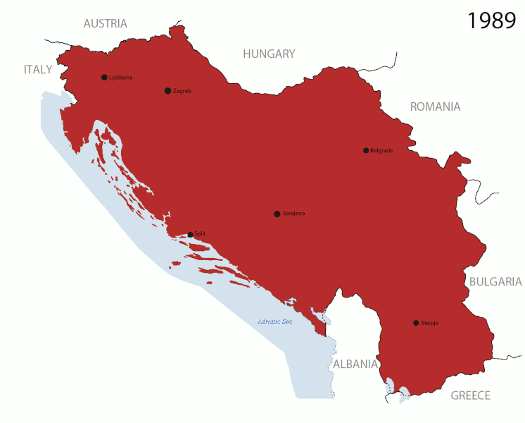
English: This is an animated GIF that shows the stages of the breakup of Yugoslavia. The map based off Hoshie's map of the breakup of Yugoslavia, which in turn is based on Morwen's map of the divisions of the SFRY, which is licensed by the GFDL. The source for the dates of independence is the CIA World Factbook. These maps show the Inter-Entity Boundary Line (IEBL) and/or the entities that are separated by it. The IEBL has been drawn based on this CIA map. |
| ရက်စွဲ | 24 July 2006 (orginal upload date) |
| ရင်းမြစ် | Made by DIREKTOR, see above for more details on sources |
| စာရေးသူ | Original by Hoshie; derivative by DIREKTOR |
| ခွင့်ပြုချက် (ဤဖိုင်ကို ပြန်လည်အသုံးပြုခြင်း) |
English: Since the original maps are GFDL, this image is as well. |
| အခြား ဗားရှင်းများ |
|


လိုင်စင်သတ်မှတ်ခြင်း

|
ဤစာတမ်းကို GNU Free Documentation License, ဗားရှင်း ၁.၂ သို့မဟုတ် Free Software Foundation မှ ဖြန့်ချီထားသော မည်သည့်ယခင်ဗားရှင်းတစ်ခုခုအောက်တွင် Invariant Sections, Front-Cover Texts နှင့် Back-Cover Texts များမပါဝင်ဘဲ ကူးယူခြင်း၊ ဖြန့်ချီခြင်း နှင့်/သို့မဟုတ် ပြင်ဆင်ပြောင်းလဲနိုင်ရန် ခွင့်ပြုသည်။ လိုင်စင်မူပွားကို GNU Free Documentation License ခေါင်းစဉ်အောက်တွင် ထည့်သွင်းထားသည်။ |
| ဤဖိုင်ကို Creative Commons Attribution-Share Alike 3.0 Unported လိုင်စင်ဖြင့် သတ်မှတ်ထားသည်။ | ||
| ||
| This licensing tag was added to this file as part of the GFDL licensing update. |
ဖိုင်မှတ်တမ်း
ဖိုင်ကို ယင်းနေ့စွဲ အတိုင်း မြင်နိုင်ရန် နေ့စွဲ/အချိန် တစ်ခုခုပေါ်တွင် ကလစ်နှိပ်ပါ။
| နေ့စွဲ/အချိန် | နမူနာပုံငယ် | မှတ်တမ်း ဒိုင်မန်းရှင်းများ | အသုံးပြုသူ | မှတ်ချက် | |
|---|---|---|---|---|---|
| ကာလပေါ် | ၁၆:၃၇၊ ၂၇ ဇူလိုင် ၂၀၁၁ | | ၁၅၄၅ × ၁၂၄၂ (၉၉ KB) | DIREKTOR | Graphic improvements |
| ၁၉:၂၀၊ ၂၆ ဇူလိုင် ၂၀၁၁ |  | ၁၅၄၅ × ၁၂၄၂ (၁၃၆ KB) | DIREKTOR | Further | |
| ၁၆:၅၆၊ ၂၆ ဇူလိုင် ၂၀၁၁ |  | ၁၅၄၅ × ၁၂၄၂ (၁၀၆ KB) | DIREKTOR | New images. | |
| ၂၁:၃၇၊ ၂၀ ဇူလိုင် ၂၀၁၁ |  | ၉၄၁ × ၈၂၄ (၄၂ KB) | DIREKTOR | Further tweaks | |
| ၂၁:၃၆၊ ၂၀ ဇူလိုင် ၂၀၁၁ |  | ၉၄၁ × ၈၂၄ (၄၂ KB) | DIREKTOR | Small fix | |
| ၂၁:၂၄၊ ၂၀ ဇူလိုင် ၂၀၁၁ |  | ၉၄၁ × ၈၂၄ (၄၂ KB) | DIREKTOR | Expanded sequence. | |
| ၁၆:၅၁၊ ၂၀ ဇူလိုင် ၂၀၁၁ |  | ၉၄၁ × ၈၂၄ (၂၈ KB) | DIREKTOR |
ဖိုင်သုံးစွဲမှု
အောက်ပါ စာမျက်နှာ သည် ဤဖိုင်ကို အသုံးပြုထားသည်:
ဂလိုဘယ် ဖိုင်သုံးစွဲမှု
အောက်ပါ အခြားဝီကီများတွင် ဤဖိုင်ကို အသုံးပြုထားသည်-
- ar.wikipedia.org တွင် အသုံးပြုမှု
- ast.wikipedia.org တွင် အသုံးပြုမှု
- azb.wikipedia.org တွင် အသုံးပြုမှု
- bg.wikipedia.org တွင် အသုံးပြုမှု
- bs.wikipedia.org တွင် အသုံးပြုမှု
- ca.wikipedia.org တွင် အသုံးပြုမှု
- ceb.wikipedia.org တွင် အသုံးပြုမှု
- cs.wikipedia.org တွင် အသုံးပြုမှု
- el.wikipedia.org တွင် အသုံးပြုမှု
- en.wikipedia.org တွင် အသုံးပြုမှု
- es.wikipedia.org တွင် အသုံးပြုမှု
- fr.wikipedia.org တွင် အသုံးပြုမှု
- gl.wikipedia.org တွင် အသုံးပြုမှု
- hi.wikipedia.org တွင် အသုံးပြုမှု
- hr.wikipedia.org တွင် အသုံးပြုမှု
- hyw.wikipedia.org တွင် အသုံးပြုမှု
- is.wikipedia.org တွင် အသုံးပြုမှု
- it.wikipedia.org တွင် အသုံးပြုမှု
- ja.wikipedia.org တွင် အသုံးပြုမှု
- ko.wikipedia.org တွင် အသုံးပြုမှု
- la.wikipedia.org တွင် အသုံးပြုမှု
- mk.wikipedia.org တွင် အသုံးပြုမှု
- ms.wikipedia.org တွင် အသုံးပြုမှု
- nl.wikipedia.org တွင် အသုံးပြုမှု
- nl.wikinews.org တွင် အသုံးပြုမှု
- pl.wikipedia.org တွင် အသုံးပြုမှု
- pnb.wikipedia.org တွင် အသုံးပြုမှု
- pt.wikipedia.org တွင် အသုံးပြုမှု
ဤဖိုင်ကို အခြားနေရာများတွင် အသုံးပြုထားမှုများအား ကြည့်ရှုရန်။