ဖိုင်:Burmese-Siamese war (1765-1767) map - EN - 001.jpg

ဤနမူနာ၏ အရွယ်အစား - ၃၄၂ × ၅၉၉ ပစ်ဇယ်။ အခြား ပုံရိပ်ပြတ်သားမှု: ၁၃၇ × ၂၄၀ ပစ်ဇယ် | ၂၇၄ × ၄၈၀ ပစ်ဇယ် | ၄၃၈ × ၇၆၈ ပစ်ဇယ် | ၅၈၄ × ၁၀၂၄ ပစ်ဇယ် | ၁၅၁၆ × ၂၆၅၇ ပစ်ဇယ်။
မူရင်းဖိုင် (၁၅၁၆ × ၂၆၅၇ pixels, ဖိုင်အရွယ်အစား - ၄၆၁ KB, MIME အမျိုးအစား image/jpeg)
| ဤဖိုင်သည် Wikimedia Commons မှဖြစ်ပြီး အခြားပရောဂျက်များတွင် သုံးကောင်းသုံးလိမ့်မည်။ ယင်း၏ ဖိုင်အကြောင်းစာမျက်နှာ တွင် ဖော်ပြထားချက်ကို အောက်တွင် ပြထားသည်။ Commons သည် မူပိုင်ခွင့်လွတ်လပ်သော မီဒီယာဖိုင်များ သိုလှောင်ထားရာ နေရာ ဖြစ်သည်။ သင်လည်း ပါဝင်ကူညီနိုင်ပါသည်။ |
အကျဉ်းချုပ်
| ဖော်ပြချက် |
English:
ไทย:
|
| ရက်စွဲ | |
| ရင်းမြစ် |
ကိုယ်ပိုင်ဖန်တီးမှု
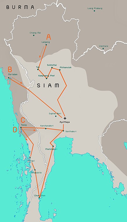
Terwiel, Bertrand. Thailand's Political History: From the 13th Century to Recent Times. Approximate boundaries of the six states that formed after Ayutthaya's destruction. |
| စာရေးသူ | Aristitleism |
| အခြား ဗားရှင်းများ |
_map_-_TH_-_002.jpg) |
လိုင်စင်သတ်မှတ်ခြင်း
ကျွန်ုပ်၊ ဤလုပ်ဆောင်ချက်၏ မူပိုင်ခွင့်ပိုင်ရှင်အနေဖြင့် ဤနေရာမှ အောက်ပါလိုင်စင်အောက်တွင် ထုတ်လွှင့်ပါသည်:
| ဤဖိုင်ကို Creative Commons CC0 1.0 Universal Public Domain Dedication အောက်တွင် ရရှိနိုင်အောင် ဆောင်ရွက်ထားပါသည်။ | |
| The person who associated a work with this deed has dedicated the work to the public domain by waiving all of their rights to the work worldwide under copyright law, including all related and neighboring rights, to the extent allowed by law. You can copy, modify, distribute and perform the work, even for commercial purposes, all without asking permission.
|
en:Burmese–Siamese War (1765–1767)

|
This historical map image could be re-created using vector graphics as an SVG file. This has several advantages; see Commons:Media for cleanup for more information. If an SVG form of this image is available, please upload it and afterwards replace this template with
{{vector version available|new image name}}.
It is recommended to name the SVG file “Burmese-Siamese war (1765-1767) map - EN - 001.svg”—then the template Vector version available (or Vva) does not need the new image name parameter. |


_map_-_EN_-_001.jpg)
ဖိုင်မှတ်တမ်း
ဖိုင်ကို ယင်းနေ့စွဲ အတိုင်း မြင်နိုင်ရန် နေ့စွဲ/အချိန် တစ်ခုခုပေါ်တွင် ကလစ်နှိပ်ပါ။
_map_-_EN_-_001.jpg&dir=prev)
_map_-_EN_-_001.jpg&offset=20110724171301)
_map_-_EN_-_001.jpg&offset=&limit=20)
_map_-_EN_-_001.jpg&offset=&limit=50)
_map_-_EN_-_001.jpg&offset=&limit=100)
_map_-_EN_-_001.jpg&offset=&limit=250)
_map_-_EN_-_001.jpg&offset=&limit=500)
| နေ့စွဲ/အချိန် | နမူနာပုံငယ် | မှတ်တမ်း ဒိုင်မန်းရှင်းများ | အသုံးပြုသူ | မှတ်ချက် | |
|---|---|---|---|---|---|
| ကာလပေါ် | ၀၈:၂၉၊ ၁၉ ဇူလိုင် ၂၀၂၃ | | ၁၅၁၆ × ၂၆၅၇ (၄၆၁ KB) | Yourlocallordandsavior | Based off the Siamese civil war borders from Terwiel's "Thailand's Political History: From the 13th Century to Recent Times". |
| ၀၈:၅၁၊ ၁၂ ဇူလိုင် ၂၀၂၃ |  | ၁၅၁၆ × ၂၆၅၇ (၄၆၄ KB) | Yourlocallordandsavior | Major updated borders (riverine and land). | |
| ၀၃:၄၀၊ ၃ မတ် ၂၀၂၃ |  | ၁၅၁၆ × ၂၆၅၇ (၄၀၂ KB) | Yourlocallordandsavior | Added Phetchabun according to 17th century urban places map in "A History of Ayutthaya" by Baker and Phongpaichit. | |
| ၀၄:၄၅၊ ၁၉ ဖေဖော်ဝါရီ ၂၀၂၃ |  | ၁၅၁၆ × ၂၆၅၇ (၄၀၃ KB) | Yourlocallordandsavior | Added Phimai, Phimai was where Prince Thepphiphit had his seat of power in the 1767-71 civil war. | |
| ၀၂:၄၆၊ ၁၉ ဖေဖော်ဝါရီ ၂၀၂၃ |  | ၁၅၁၆ × ၂၆၅၇ (၄၀၄ KB) | Yourlocallordandsavior | . | |
| ၀၁:၂၇၊ ၁၉ ဖေဖော်ဝါရီ ၂၀၂၃ |  | ၁၅၁၆ × ၂၆၅၇ (၄၀၆ KB) | Yourlocallordandsavior | Removed the Forest Mueang and adjusted borders. | |
| ၁၇:၂၃၊ ၁၉ ဩဂုတ် ၂၀၁၁ |  | ၁၅၁၆ × ၂၆၅၇ (၁.၀၅ MB) | Tiemianwusi | Changing the colour of the third territories (from pale blue to pale taupe) | |
| ၁၅:၄၇၊ ၁၉ ဩဂုတ် ၂၀၁၁ |  | ၁၅၁၆ × ၂၆၅၇ (၁.၀၅ MB) | Tiemianwusi | (1) Correcting boundaries, (2) Darker Burmese territories, (3) Recolouring third territories, (4) Correcting advance routes. | |
| ၀၈:၄၇၊ ၂၅ ဇူလိုင် ၂၀၁၁ |  | ၁၅၁၆ × ၂၆၅၇ (၁.၀၅ MB) | Tiemianwusi | "Margui" → "Mergui" | |
| ၁၇:၁၃၊ ၂၄ ဇူလိုင် ၂၀၁၁ |  | ၁၅၁၆ × ၂၆၅၇ (၁.၀၅ MB) | Tiemianwusi | Correcting territories |
ဖိုင်သုံးစွဲမှု
အောက်ပါ စာမျက်နှာ သည် ဤဖိုင်ကို အသုံးပြုထားသည်:
ဂလိုဘယ် ဖိုင်သုံးစွဲမှု
အောက်ပါ အခြားဝီကီများတွင် ဤဖိုင်ကို အသုံးပြုထားသည်-
- ar.wikipedia.org တွင် အသုံးပြုမှု
- en.wikipedia.org တွင် အသုံးပြုမှု
- es.wikipedia.org တွင် အသုံးပြုမှု
- it.wikipedia.org တွင် အသုံးပြုမှု
- km.wikipedia.org တွင် အသုံးပြုမှု
- uk.wikipedia.org တွင် အသုံးပြုမှု
- vi.wikipedia.org တွင် အသုံးပြုမှု
- www.wikidata.org တွင် အသုံးပြုမှု
- zh.wikipedia.org တွင် အသုံးပြုမှု
_map_-_EN_-_001.jpg)