ဖိုင်:California Topography-MEDIUM.png
ဤနမူနာ၏ အရွယ်အစား - ၅၅၈ × ၅၉၉ ပစ်ဇယ်။ အခြား ပုံရိပ်ပြတ်သားမှု: ၂၂၃ × ၂၄၀ ပစ်ဇယ် | ၄၄၇ × ၄၈၀ ပစ်ဇယ် | ၇၁၅ × ၇၆၈ ပစ်ဇယ် | ၉၅၃ × ၁၀၂၄ ပစ်ဇယ် | ၁၈၆၂ × ၂၀၀၀ ပစ်ဇယ်။
မူရင်းဖိုင် (၁၈၆၂ × ၂၀၀၀ pixels, ဖိုင်အရွယ်အစား - ၂.၂၅ MB, MIME အမျိုးအစား image/png)
| ဤဖိုင်သည် Wikimedia Commons မှဖြစ်ပြီး အခြားပရောဂျက်များတွင် သုံးကောင်းသုံးလိမ့်မည်။ ယင်း၏ ဖိုင်အကြောင်းစာမျက်နှာ တွင် ဖော်ပြထားချက်ကို အောက်တွင် ပြထားသည်။ Commons သည် မူပိုင်ခွင့်လွတ်လပ်သော မီဒီယာဖိုင်များ သိုလှောင်ထားရာ နေရာ ဖြစ်သည်။ သင်လည်း ပါဝင်ကူညီနိုင်ပါသည်။ |
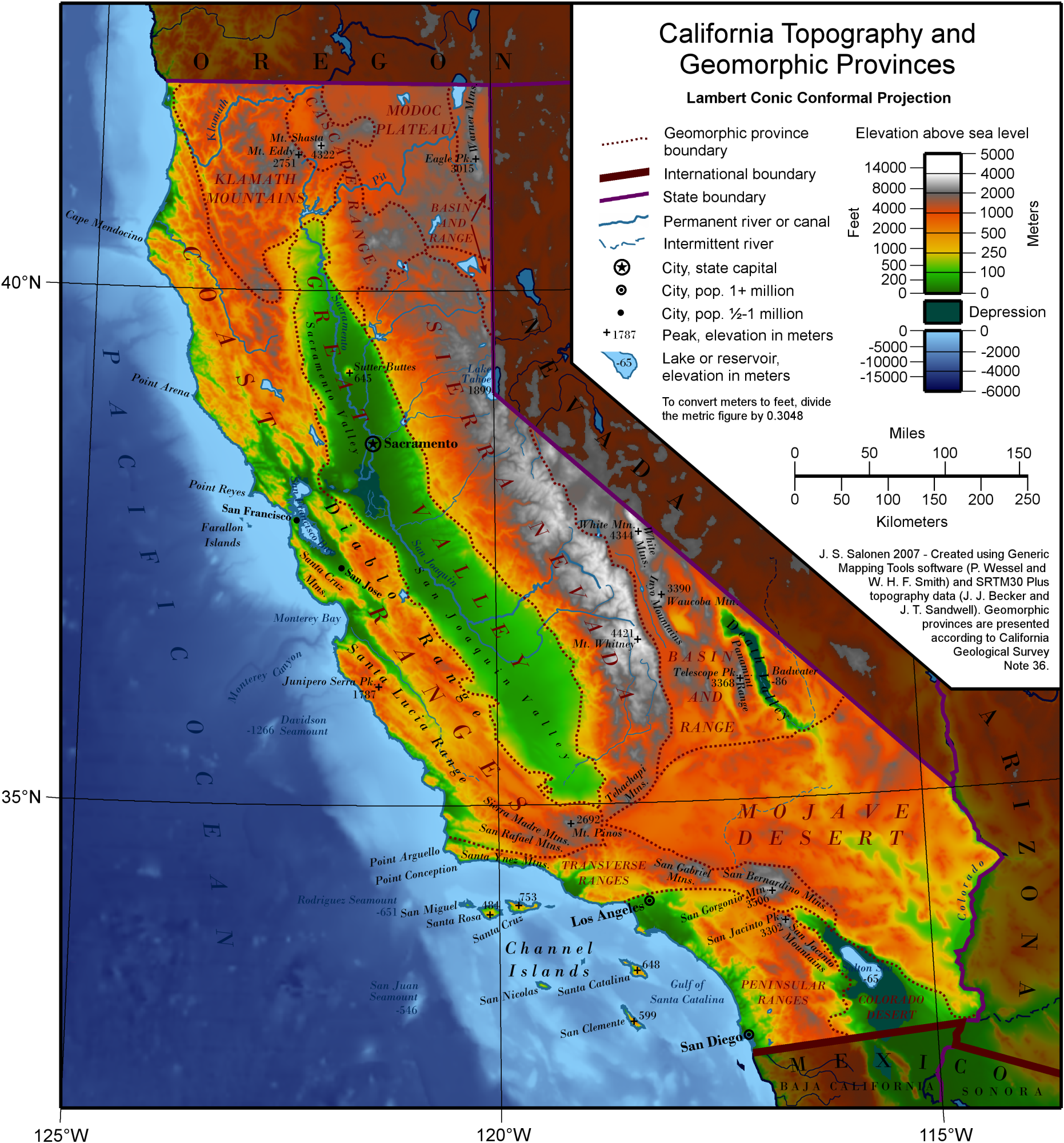
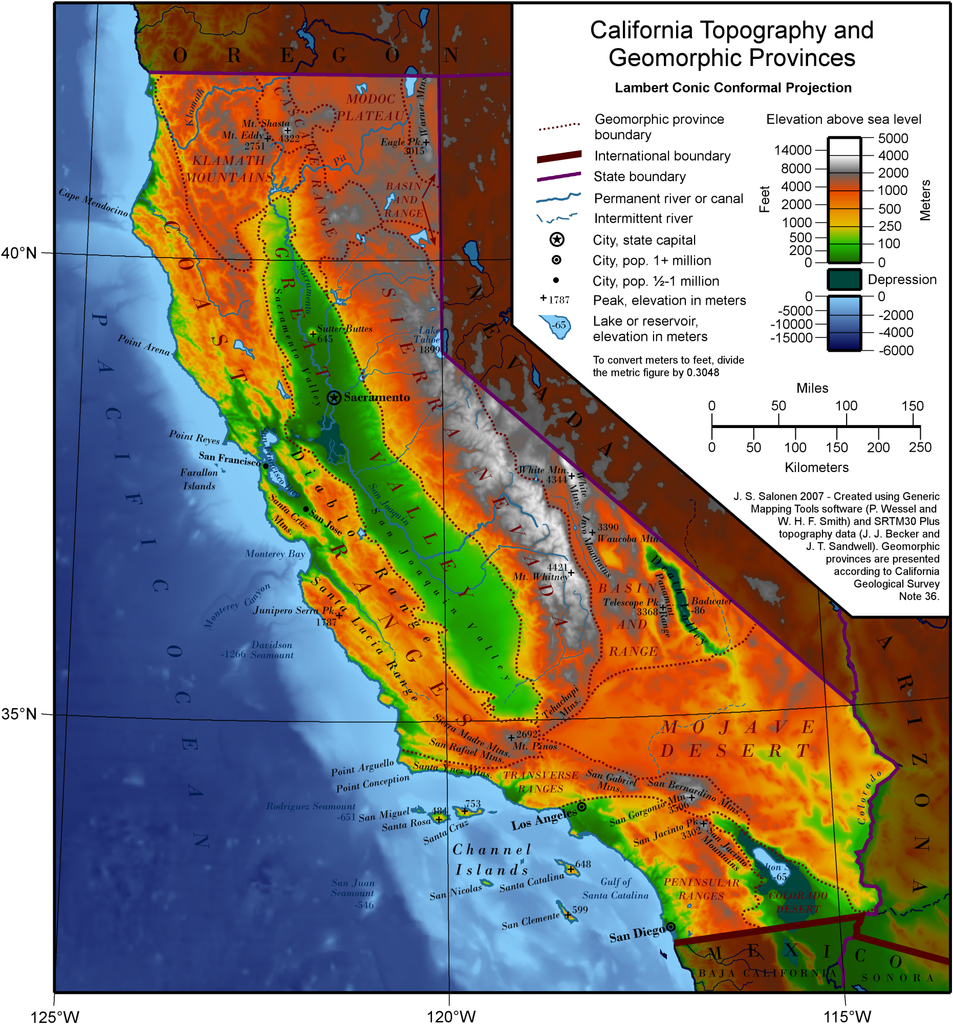
| ဖော်ပြချက် | A map of California showing topography and geomorphic provinces. | ||||||||
| ရက်စွဲ | |||||||||
| ရင်းမြစ် | Own work by the original uploader, using The Generic Mapping Tools | ||||||||
| စာရေးသူ | J.S. Salonen (ဆွေးနွေး · ပံ့ပိုး) | ||||||||
| ခွင့်ပြုချက် (ဤဖိုင်ကို ပြန်လည်အသုံးပြုခြင်း) |
Ssalonen at the English Wikipedia၊ ဤလုပ်ဆောင်ချက်၏ မူပိုင်ခွင့်ပိုင်ရှင်အနေဖြင့် ဤနေရာမှ အောက်ပါလိုင်စင်အောက်တွင် ထုတ်လွှင့်ပါသည်:
|
||||||||
| အခြား ဗားရှင်းများ |
|


ဖိုင်မှတ်တမ်း
ဖိုင်ကို ယင်းနေ့စွဲ အတိုင်း မြင်နိုင်ရန် နေ့စွဲ/အချိန် တစ်ခုခုပေါ်တွင် ကလစ်နှိပ်ပါ။
| နေ့စွဲ/အချိန် | နမူနာပုံငယ် | မှတ်တမ်း ဒိုင်မန်းရှင်းများ | အသုံးပြုသူ | မှတ်ချက် | |
|---|---|---|---|---|---|
| ကာလပေါ် | ၀၉:၄၆၊ ၃၁ ဇူလိုင် ၂၀၀၉ | | ၁၈၆၂ × ၂၀၀၀ (၂.၂၅ MB) | Urban~commonswiki | {{Information |Description=A map of California showing topography and geomorphic provinces. |Source=http://en.wikipedia.org/wiki/File:California_Topography-MEDIUM.png |Date= |Author=User:Ssalonen |Permission= |other_versions= }} {{GFDL-self-no-disclaimers |
ဖိုင်သုံးစွဲမှု
အောက်ပါ စာမျက်နှာ သည် ဤဖိုင်ကို အသုံးပြုထားသည်:
ဂလိုဘယ် ဖိုင်သုံးစွဲမှု
အောက်ပါ အခြားဝီကီများတွင် ဤဖိုင်ကို အသုံးပြုထားသည်-
- am.wikipedia.org တွင် အသုံးပြုမှု
- ar.wikipedia.org တွင် အသုံးပြုမှု
- bn.wikipedia.org တွင် အသုံးပြုမှု
- bo.wikipedia.org တွင် အသုံးပြုမှု
- en.wikiversity.org တွင် အသုံးပြုမှု
- eo.wikipedia.org တွင် အသုံးပြုမှု
- es.wikipedia.org တွင် အသုံးပြုမှု
- fr.wikipedia.org တွင် အသုံးပြုမှု
- he.wikipedia.org တွင် အသုံးပြုမှု
- incubator.wikimedia.org တွင် အသုံးပြုမှု
- it.wikipedia.org တွင် အသုံးပြုမှု
- ja.wikipedia.org တွင် အသုံးပြုမှု
- krc.wikipedia.org တွင် အသုံးပြုမှု
- lv.wikipedia.org တွင် အသုံးပြုမှု
- mk.wikipedia.org တွင် အသုံးပြုမှု
- oc.wikipedia.org တွင် အသုံးပြုမှု
- pt.wikipedia.org တွင် အသုံးပြုမှု
- ro.wikipedia.org တွင် အသုံးပြုမှု
- sr.wikipedia.org တွင် အသုံးပြုမှု
- tr.wikipedia.org တွင် အသုံးပြုမှု
- www.wikidata.org တွင် အသုံးပြုမှု