ဖိုင်:Claudius Ptolemy- The World.jpg

ဤနမူနာ၏ အရွယ်အစား - ၈၀၀ × ၅၇၆ ပစ်ဇယ်။ အခြား ပုံရိပ်ပြတ်သားမှု: ၃၂၀ × ၂၃၀ ပစ်ဇယ် | ၆၄၀ × ၄၆၁ ပစ်ဇယ် | ၁၀၂၄ × ၇၃၇ ပစ်ဇယ် | ၁၂၈၀ × ၉၂၂ ပစ်ဇယ် | ၂၅၆၀ × ၁၈၄၃ ပစ်ဇယ် | ၈၀၇၃ × ၅၈၁၃ ပစ်ဇယ်။
မူရင်းဖိုင် (၈၀၇၃ × ၅၈၁၃ pixels, ဖိုင်အရွယ်အစား - ၁၈.၀၃ MB, MIME အမျိုးအစား image/jpeg)
| ဤဖိုင်သည် Wikimedia Commons မှဖြစ်ပြီး အခြားပရောဂျက်များတွင် သုံးကောင်းသုံးလိမ့်မည်။ ယင်း၏ ဖိုင်အကြောင်းစာမျက်နှာ တွင် ဖော်ပြထားချက်ကို အောက်တွင် ပြထားသည်။ Commons သည် မူပိုင်ခွင့်လွတ်လပ်သော မီဒီယာဖိုင်များ သိုလှောင်ထားရာ နေရာ ဖြစ်သည်။ သင်လည်း ပါဝင်ကူညီနိုင်ပါသည်။ |
| အနုပညာရှင် |
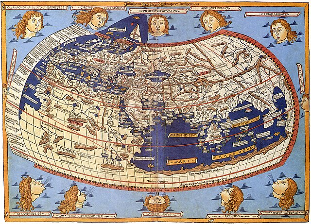
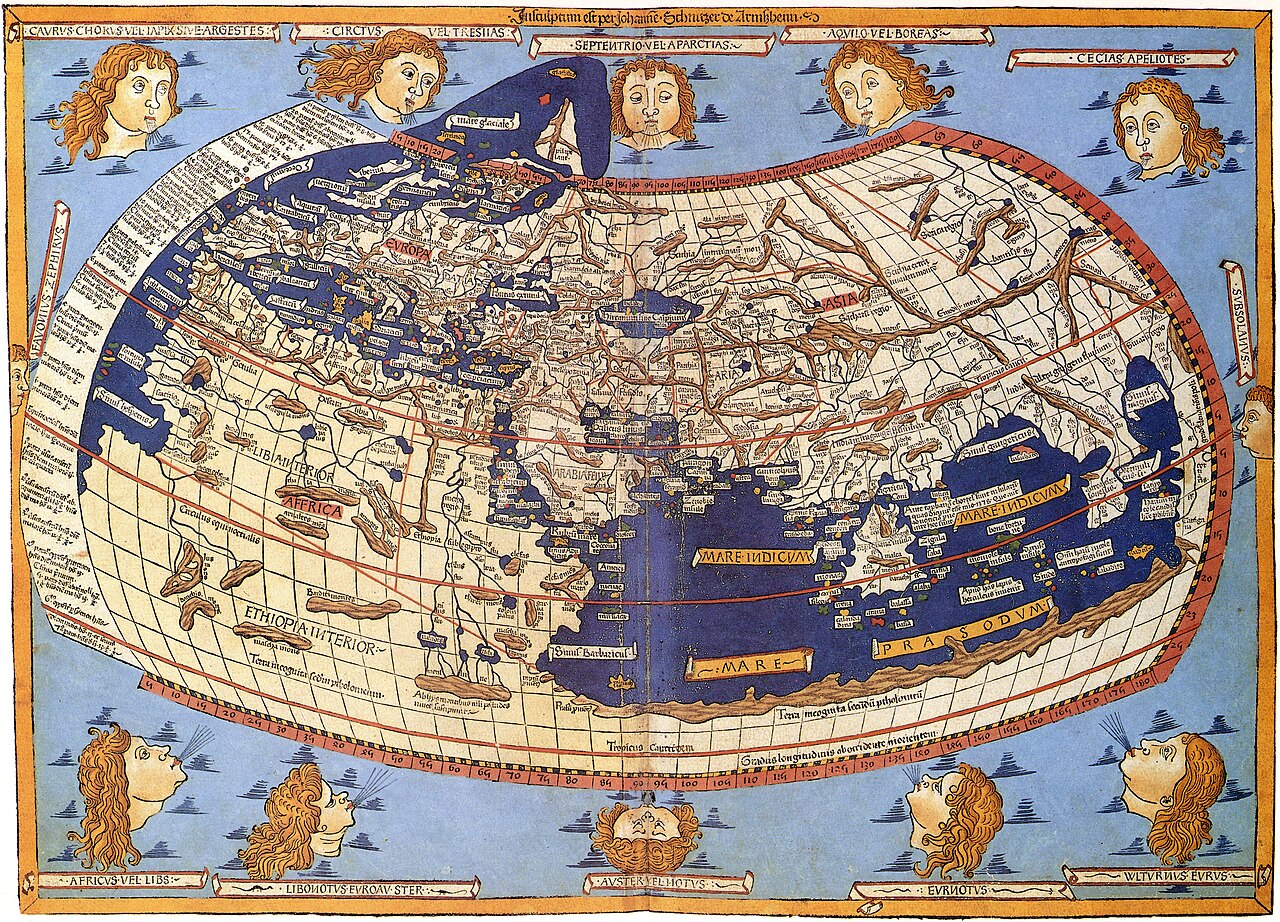
Lord Nicolas the German (Donnus Nicholas Germanus), cartographer Johann the Blockcutter of Armsheim (Johannes Schnitzer or Johannes de Armssheim), engraver |
||||
| စာရေးသူ | |||||
| ဖော်ပြချက် |
English: The world map from Leinhart Holle's 1482 edition of Nicolaus Germanus's emendations to Jacobus Angelus's 1406 Latin translation of Maximus Planudes's late-13th century rediscovered Greek manuscripts of Ptolemy's 2nd-century Geography. |
||||
| ရက်စွဲ | ၁၄၈၂ | ||||
| Source/Photographer | Decorative Maps by Roderick Barron - ISBN 1851702989 | ||||
| ခွင့်ပြုချက် (ဤဖိုင်ကို ပြန်လည်အသုံးပြုခြင်း) |
|
||||
| အခြား ဗားရှင်းများ |
|
||||


ဖိုင်မှတ်တမ်း
ဖိုင်ကို ယင်းနေ့စွဲ အတိုင်း မြင်နိုင်ရန် နေ့စွဲ/အချိန် တစ်ခုခုပေါ်တွင် ကလစ်နှိပ်ပါ။
| နေ့စွဲ/အချိန် | နမူနာပုံငယ် | မှတ်တမ်း ဒိုင်မန်းရှင်းများ | အသုံးပြုသူ | မှတ်ချက် | |
|---|---|---|---|---|---|
| ကာလပေါ် | ၀၈:၂၆၊ ၃၁ အောက်တိုဘာ ၂၀၂၃ | | ၈၀၇၃ × ၅၈၁၃ (၁၈.၀၃ MB) | OnlySlightlyDamp | Reverted to version as of 03:58, 3 July 2007 (UTC) |
| ၀၈:၀၈၊ ၂၂ အောက်တိုဘာ ၂၀၂၃ |  | ၈၂၂၆ × ၅၉၁၉ (၁၉.၅၃ MB) | Shekishekiey | Reverted to version as of 03:54, 3 July 2007 (UTC) | |
| ၀၃:၅၈၊ ၃ ဇူလိုင် ၂၀၀၇ |  | ၈၀၇၃ × ၅၈၁၃ (၁၈.၀၃ MB) | SCEhardt | cropped & rotated | |
| ၀၃:၅၄၊ ၃ ဇူလိုင် ၂၀၀၇ |  | ၈၂၂၆ × ၅၉၁၉ (၁၉.၅၃ MB) | SCEhardt | {{Information |Description=Claudius Ptolemy: The World |Source=Scanned by Scott Ehardt from Decorative Maps by Roderick Barron - ISBN 1851702989 |Date=1482 |Author=Johannes Schnitzer, engraver<br>Claudius Ptolemy, cartographer |Permissio |
ဖိုင်သုံးစွဲမှု
အောက်ပါ စာမျက်နှာ သည် ဤဖိုင်ကို အသုံးပြုထားသည်:
ဂလိုဘယ် ဖိုင်သုံးစွဲမှု
အောက်ပါ အခြားဝီကီများတွင် ဤဖိုင်ကို အသုံးပြုထားသည်-
- af.wikipedia.org တွင် အသုံးပြုမှု
- ar.wikipedia.org တွင် အသုံးပြုမှု
- az.wikipedia.org တွင် အသုံးပြုမှု
- be.wikipedia.org တွင် အသုံးပြုမှု
- bg.wikipedia.org တွင် အသုံးပြုမှု
- bh.wikipedia.org တွင် အသုံးပြုမှု
- bn.wikipedia.org တွင် အသုံးပြုမှု
- br.wikipedia.org တွင် အသုံးပြုမှု
- ca.wikipedia.org တွင် အသုံးပြုမှု
- de.wikipedia.org တွင် အသုံးပြုမှု
- el.wikipedia.org တွင် အသုံးပြုမှု
- en.wikipedia.org တွင် အသုံးပြုမှု
- eo.wikipedia.org တွင် အသုံးပြုမှု
- es.wikipedia.org တွင် အသုံးပြုမှု
- eu.wikipedia.org တွင် အသုံးပြုမှု
- fa.wikipedia.org တွင် အသုံးပြုမှု
- fr.wikipedia.org တွင် အသုံးပြုမှု
- fr.wikiversity.org တွင် အသုံးပြုမှု
- fy.wikipedia.org တွင် အသုံးပြုမှု
- ga.wikipedia.org တွင် အသုံးပြုမှု
- hi.wikipedia.org တွင် အသုံးပြုမှု
- hu.wikipedia.org တွင် အသုံးပြုမှု
- hy.wikipedia.org တွင် အသုံးပြုမှု
- id.wikipedia.org တွင် အသုံးပြုမှု
ဤဖိုင်ကို အခြားနေရာများတွင် အသုံးပြုထားမှုများအား ကြည့်ရှုရန်။