ဖိုင်:Colonisation2.gif

မူရင်းဖိုင် (၁၈၄၉ × ၈၁၀ pixels, ဖိုင်အရွယ်အစား - ၂.၀၈ MB, MIME အမျိုးအစား image/gif, looped, ၁၂ frames, ၄၈ s)
| ဤဖိုင်သည် Wikimedia Commons မှဖြစ်ပြီး အခြားပရောဂျက်များတွင် သုံးကောင်းသုံးလိမ့်မည်။ ယင်း၏ ဖိုင်အကြောင်းစာမျက်နှာ တွင် ဖော်ပြထားချက်ကို အောက်တွင် ပြထားသည်။ Commons သည် မူပိုင်ခွင့်လွတ်လပ်သော မီဒီယာဖိုင်များ သိုလှောင်ထားရာ နေရာ ဖြစ်သည်။ သင်လည်း ပါဝင်ကူညီနိုင်ပါသည်။ |
အကျဉ်းချုပ်
| ဖော်ပြချက် |
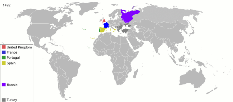
English: Map indicating the territories colonized by the European powers, United States and Japan.
Русский: Карта с указанием территорий, колонизированных Европейскими державами, Соединёнными штатами и Японией.
|
||||||||||||||||
| ရက်စွဲ | ၂၃ ဇွန် ၂၀၀၈ (original upload date) | ||||||||||||||||
| ရင်းမြစ် | Transferred from en.wikipedia to Commons. | ||||||||||||||||
| စာရေးသူ | ArdadN at အင်္ဂလိပ် ဝီကီပီးဒီးယား | ||||||||||||||||
| အခြား ဗားရှင်းများ |
The maps can be seen separately by using this template:
Derivative works of this file: |
||||||||||||||||
.gif)
.jpg)
._LOC_2001620596.jpg)
လိုင်စင်သတ်မှတ်ခြင်း
| I, the copyright holder of this work, release this work into the public domain. This applies worldwide. In some countries this may not be legally possible; if so: အကျွန်ုပ်သည် ဤဖန်တီးမှုလက်ရာကို ဥပဒေအရလိုအပ်ခြင်းမရှိသည့် မည်သည့်အခြေအနေမျိုးတွက်မဆို၊ မည်သို့သော ရည်ရွယ်ချက်အတွက်မဆို ၎င်းကို မည်သူမဆို အသုံးပြုပိုင်ခွင့်အား ပေးအပ်သည်။ |
ဖိုင်မှတ်တမ်း
ဖိုင်ကို ယင်းနေ့စွဲ အတိုင်း မြင်နိုင်ရန် နေ့စွဲ/အချိန် တစ်ခုခုပေါ်တွင် ကလစ်နှိပ်ပါ။
| နေ့စွဲ/အချိန် | နမူနာပုံငယ် | မှတ်တမ်း ဒိုင်မန်းရှင်းများ | အသုံးပြုသူ | မှတ်ချက် | |
|---|---|---|---|---|---|
| ကာလပေါ် | ၁၅:၄၀၊ ၅ အောက်တိုဘာ ၂၀၂၀ | | ၁၈၄၉ × ၈၁၀ (၂.၀၈ MB) | Ориенталист | Colour correction |
| ၁၄:၁၉၊ ၁၀ မေ ၂၀၂၀ |  | ၈၀၀ × ၃၇၉ (၆၀၆ KB) | Ориенталист | Cosmetic changes | |
| ၀၉:၃၉၊ ၅ ဧပြီ ၂၀၂၀ |  | ၈၀၀ × ၃၅၁ (၅၆၁ KB) | Ориенталист | Last time i forgot 1914. Аdded it, little changes | |
| ၀၉:၄၉၊ ၄ ဧပြီ ၂၀၂၀ |  | ၈၀၀ × ၃၅၁ (၄၉၅ KB) | Ориенталист | Changed maps for 1492, 1550, 1660, 1754. Added a map for 1600. | |
| ၁၁:၂၉၊ ၉ ဇန်နဝါရီ ၂၀၁၉ |  | ၁၄၂၅ × ၆၂၅ (၁၀၁ KB) | ArdadN | fixed Ireland 1754, Morocco 1914, Russian-German border 1885 and 1914, German-French border 1885 and 1914, German-Danish border 1885, Austria and Sudetenland 1938 | |
| ၀၈:၅၄၊ ၂၃ ဇူလိုင် ၂၀၁၈ |  | ၁၄၂၅ × ၆၂၅ (၁၀၁ KB) | SuperSucker | fix - believe in 1938 ethiopia was under european occupation as well.. italy had taken the capital Addis-Abeba in 1936 indeed | |
| ၂၀:၂၇၊ ၄ ဇွန် ၂၀၁၂ |  | ၁၄၂၅ × ၆၂၅ (၁၀၁ KB) | Mnlk | i corrected the error that falsly depicted ethiopia as colony of fascist italy | |
| ၁၉:၄၉၊ ၁၉ ဖေဖော်ဝါရီ ၂၀၁၁ |  | ၁၄၂၅ × ၆၂၅ (၂၄၆ KB) | NordNordWest | corrected according to http://de.wikipedia.org/w/index.php?title=Benutzer_Diskussion%3ANordNordWest&action=historysubmit&diff=85468547&oldid=85447379 | |
| ၁၉:၄၀၊ ၁၈ ဖေဖော်ဝါရီ ၂၀၁၁ |  | ၁၄၂၅ × ၆၂၅ (၂၃၆ KB) | NordNordWest | corrected according to http://de.wikipedia.org/w/index.php?title=Benutzer_Diskussion%3ANordNordWest&action=historysubmit&diff=85447379&oldid=85351900 | |
| ၁၉:၄၂၊ ၁၆ စက်တင်ဘာ ၂၀၁၀ |  | ၁၄၂၅ × ၆၂၅ (၂၅၇ KB) | NordNordWest | further corrections |
ဖိုင်သုံးစွဲမှု
အောက်ပါ စာမျက်နှာ သည် ဤဖိုင်ကို အသုံးပြုထားသည်:
ဂလိုဘယ် ဖိုင်သုံးစွဲမှု
အောက်ပါ အခြားဝီကီများတွင် ဤဖိုင်ကို အသုံးပြုထားသည်-
- ar.wikipedia.org တွင် အသုံးပြုမှု
- av.wikipedia.org တွင် အသုံးပြုမှု
- azb.wikipedia.org တွင် အသုံးပြုမှု
- az.wikipedia.org တွင် အသုံးပြုမှု
- ba.wikipedia.org တွင် အသုံးပြုမှု
- be-tarask.wikipedia.org တွင် အသုံးပြုမှု
- be.wikipedia.org တွင် အသုံးပြုမှု
- bg.wikipedia.org တွင် အသုံးပြုမှု
- bn.wikipedia.org တွင် အသုံးပြုမှု
- ce.wikipedia.org တွင် အသုံးပြုမှု
- cs.wikipedia.org တွင် အသုံးပြုမှု
- da.wikipedia.org တွင် အသုံးပြုမှု
- de.wikipedia.org တွင် အသုံးပြုမှု
- diq.wikipedia.org တွင် အသုံးပြုမှု
- en.wikipedia.org တွင် အသုံးပြုမှု
- History of Europe
- Early modern period
- Maritime history
- Colonial empire
- History of colonialism
- User:Palaeovia
- Portal:Maps/Maps/World
- Portal:Maps/Maps/World/18
- History of globalization
- User talk:AtomAtom
- Western world
- User:Meclee/proj4-sandbox
- User:Kazkaskazkasako/Books/History
- Outline of globalization
- Decoloniality
- Wikipedia:Graphics Lab/Map workshop/Archive/Apr 2014
- User:Bongan
- User:Bongan/genetic history of the human race
- en.wikibooks.org တွင် အသုံးပြုမှု
ဤဖိုင်ကို အခြားနေရာများတွင် အသုံးပြုထားမှုများအား ကြည့်ရှုရန်။