ဖိုင်:EU-Denmark.svg

Size of this PNG preview of this SVG file: ၇၁၃ × ၆၀၀ ပစ်ဇယ်. အခြား ပုံရိပ်ပြတ်သားမှု: ၂၈၅ × ၂၄၀ ပစ်ဇယ် | ၅၇၁ × ၄၈၀ ပစ်ဇယ် | ၉၁၃ × ၇၆၈ ပစ်ဇယ် | ၁၂၁၈ × ၁၀၂၄ ပစ်ဇယ် | ၂၄၃၅ × ၂၀၄၈ ပစ်ဇယ် | ၂၀၄၅ × ၁၇၂၀ ပစ်ဇယ်။
မူရင်းဖိုင် (SVG ဖိုင်, ၂၀၄၅ × ၁၇၂၀ pixels ကို အကြံပြုသည်, ဖိုင်အရွယ်အစား - ၇.၃၃ MB)
| ဤဖိုင်သည် Wikimedia Commons မှဖြစ်ပြီး အခြားပရောဂျက်များတွင် သုံးကောင်းသုံးလိမ့်မည်။ ယင်း၏ ဖိုင်အကြောင်းစာမျက်နှာ တွင် ဖော်ပြထားချက်ကို အောက်တွင် ပြထားသည်။ Commons သည် မူပိုင်ခွင့်လွတ်လပ်သော မီဒီယာဖိုင်များ သိုလှောင်ထားရာ နေရာ ဖြစ်သည်။ သင်လည်း ပါဝင်ကူညီနိုင်ပါသည်။ |
အကျဉ်းချုပ်
| ဖော်ပြချက် |
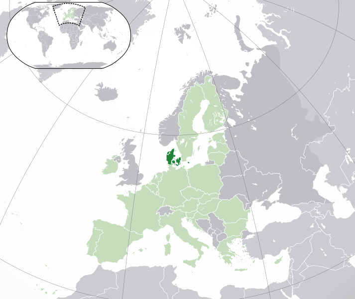
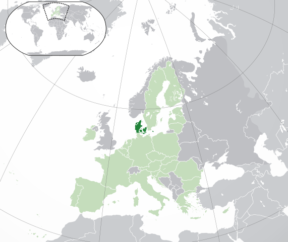
English: (Dark-Green) Denmark. (Light-Green) The rest of the European Union (EU). (Dark-gray) The rest of Europe. (Light-gray) The surrounding region.
See also: |
| SVG genesis | |
| ရက်စွဲ | |
| ရင်းမြစ် | Own work based on: Location European nation states.svg |
| စာရေးသူ | NuclearVacuum |
| အခြား ဗားရှင်းများ |
|
| SVG genesis |


လိုင်စင်သတ်မှတ်ခြင်း
ကျွန်ုပ်၊ ဤလုပ်ဆောင်ချက်၏ မူပိုင်ခွင့်ပိုင်ရှင်အနေဖြင့် ဤနေရာမှ အောက်ပါလိုင်စင်များအောက်တွင် ထုတ်လွှင့်ပါသည်:
ဤဖိုင်ကို Creative Commons Attribution-Share Alike 3.0 Unported လိုင်စင်ဖြင့် သတ်မှတ်ထားသည်။
- သင်သည် လွတ်လပ်စွာ:
- မျှဝေရန် – ဖန်တီးမှုကို ကူးယူရန်၊ ဖြန့်ဖြူးရန်နှင့် ထုတ်လွှင့်ရန်
- ပြန်ရောနှောရန် – ဖန်တီးမှုကို ပြင်ဆင်ညှိနှိုင်းရန်
- အောက်ပါ အခြေအနေများတွင်:
- မှတ်ယူနိုင်ခြင်း – ပြောင်းလဲမှုများ ပြုလုပ်ခဲ့ပါက ဖန်တီးသူ သို့မဟုတ် လိုင်စင်ရှိသူမှ သတ်မှတ်သော အမျိုးအစားကို လိုက်နာရမည် (ဆိုလိုသည်မှာ သင့်အား သို့မဟုတ် သင့်ဖန်တီးမှုတွင် အသုံးပြုခြင်းအား ထောက်ခံချက်ပေးသည်ဟု မဆိုလိုပါ)။
- ထပ်တူမျှဝေ – ဤဖန်တီးမှုအား ပြင်ဆင်ခြင်း၊ ပြောင်းလဲခြင်း သို့မဟုတ် ထပ်ဆင့် ဖန်တီးခြင်း ပြုလုပ်ပါက ရရှိလာသော ဖန်တီးမှုကို ဤဖန်တီးမှုနှင့် သို့မဟုတ် ဆင်တူသော လိုင်စင်ဖြင့်သာ ဖြန့်ချိသင့်သည်။

|
ဤစာတမ်းကို GNU Free Documentation License, ဗားရှင်း ၁.၂ သို့မဟုတ် Free Software Foundation မှ ဖြန့်ချီထားသော မည်သည့်ယခင်ဗားရှင်းတစ်ခုခုအောက်တွင် Invariant Sections, Front-Cover Texts နှင့် Back-Cover Texts များမပါဝင်ဘဲ ကူးယူခြင်း၊ ဖြန့်ချီခြင်း နှင့်/သို့မဟုတ် ပြင်ဆင်ပြောင်းလဲနိုင်ရန် ခွင့်ပြုသည်။ လိုင်စင်မူပွားကို GNU Free Documentation License ခေါင်းစဉ်အောက်တွင် ထည့်သွင်းထားသည်။ |
သင်အလိုရှိရာ လိုင်စင်ကို ရွေးချယ်နိုင်ပါသည်။
ဖိုင်မှတ်တမ်း
ဖိုင်ကို ယင်းနေ့စွဲ အတိုင်း မြင်နိုင်ရန် နေ့စွဲ/အချိန် တစ်ခုခုပေါ်တွင် ကလစ်နှိပ်ပါ။
| နေ့စွဲ/အချိန် | နမူနာပုံငယ် | မှတ်တမ်း ဒိုင်မန်းရှင်းများ | အသုံးပြုသူ | မှတ်ချက် | |
|---|---|---|---|---|---|
| ကာလပေါ် | ၀၄:၄၉၊ ၁ ဖေဖော်ဝါရီ ၂၀၂၀ | | ၂၀၄၅ × ၁၇၂၀ (၇.၃၃ MB) | Rob984 | UK and Gibraltar have left the EU. New base which includes all of Portugal's islands within frame, as well as Arctic Russian islands part of Europe. Also fixed Flevoland in the Netherlands. |
| ၁၉:၂၄၊ ၂၅ အောက်တိုဘာ ၂၀၁၆ |  | ၂၀၄၅ × ၁၇၂၀ (၇.၃၂ MB) | Giorgi Balakhadze | fix | |
| ၁၆:၃၇၊ ၂၅ အောက်တိုဘာ ၂၀၁၆ |  | ၂၀၄၅ × ၁၇၂၀ (၇.၃၃ MB) | Giorgi Balakhadze | Rv of sockpuppet and per COM:OVERWRITE | |
| ၁၄:၄၆၊ ၂၁ ဖေဖော်ဝါရီ ၂၀၁၅ |  | ၂၀၄၅ × ၁၇၂၀ (၇.၃၈ MB) | Hazhk | Reverted to version as of 19:20, 19 November 2014 | |
| ၁၄:၀၅၊ ၂၁ ဖေဖော်ဝါရီ ၂၀၁၅ |  | ၂၀၄၅ × ၁၇၂၀ (၇.၃၈ MB) | VS6507 | Spain. Greece. Slovakia. Cyprus. Romania VETO | |
| ၁၉:၂၀၊ ၁၉ နိုဝင်ဘာ ၂၀၁၄ |  | ၂၀၄၅ × ၁၇၂၀ (၇.၃၈ MB) | Leftcry | Reverted to version as of 19:36, 16 November 2014 Stop making such edits without consensus! Start a discussion on the talk page first! | |
| ၁၁:၀၉၊ ၁၉ နိုဝင်ဘာ ၂၀၁၄ |  | ၂၀၄၅ × ၁၇၂၀ (၇.၃၈ MB) | Mondolkiri1 | Correcting one island in Norway, therefore, also in the Nordic Council | |
| ၁၀:၃၀၊ ၁၉ နိုဝင်ဘာ ၂၀၁၄ |  | ၂၀၄၅ × ၁၇၂၀ (၇.၃၈ MB) | Mondolkiri1 | Corrections about some islands belonging to Norway, therefore, to the Nordic Council. | |
| ၁၀:၂၂၊ ၁၉ နိုဝင်ဘာ ၂၀၁၄ |  | ၂၀၄၅ × ၁၇၂၀ (၇.၃၈ MB) | Mondolkiri1 | Correction about some islands in Norway, therefore, in the Nordic Council | |
| ၀၆:၄၅၊ ၁၉ နိုဝင်ဘာ ၂၀၁၄ |  | ၂၀၄၅ × ၁၇၂၀ (၇.၃၈ MB) | Mondolkiri1 | Reverted to version as of 21:59, 18 November 2014 Sorry but this map is far more logic since Greenland and the Faroe Islands belong to Denmark and Nordic Council but not to EU! Don't be like an Eurocrat supremacist, please! |
ဖိုင်သုံးစွဲမှု
အောက်ပါ 2 စာမျက်နှာများ သည် ဤဖိုင်ကို အသုံးပြုထားသည်:
ဂလိုဘယ် ဖိုင်သုံးစွဲမှု
အောက်ပါ အခြားဝီကီများတွင် ဤဖိုင်ကို အသုံးပြုထားသည်-
- ady.wikipedia.org တွင် အသုံးပြုမှု
- af.wikipedia.org တွင် အသုံးပြုမှု
- ar.wikipedia.org တွင် အသုံးပြုမှု
- الدنمارك
- بوابة:الدنمارك/واجهة
- بوابة:الدنمارك
- مستخدم:ElWaliElAlaoui/ملعب 8
- معاملة المثليين في الدنمارك
- مستخدم:جار الله/قائمة صور مقالات العلاقات الثنائية
- العلاقات الأنغولية الدنماركية
- العلاقات الدنماركية الكورية الجنوبية
- العلاقات الدنماركية الإريترية
- العلاقات الدنماركية السويسرية
- العلاقات الدنماركية الليختنشتانية
- العلاقات الدنماركية البوليفية
- العلاقات الدنماركية الموزمبيقية
- العلاقات الألبانية الدنماركية
- العلاقات الدنماركية البلجيكية
- العلاقات الدنماركية الإثيوبية
- العلاقات الدنماركية البيلاروسية
- العلاقات الدنماركية الطاجيكستانية
- العلاقات الدنماركية الرومانية
- العلاقات الأرجنتينية الدنماركية
- العلاقات الدنماركية الغامبية
- العلاقات الدنماركية القبرصية
- العلاقات الدنماركية السيراليونية
- العلاقات الدنماركية النيبالية
- العلاقات الدنماركية الليبيرية
- العلاقات التشيكية الدنماركية
- العلاقات الدنماركية الميانمارية
- العلاقات الدنماركية الكندية
- العلاقات الدنماركية الزيمبابوية
- العلاقات الدنماركية الإسرائيلية
- العلاقات الدنماركية البالاوية
- العلاقات الدنماركية المالية
- العلاقات الدنماركية النيجيرية
- العلاقات الدنماركية اليمنية
- العلاقات الدنماركية الفانواتية
- العلاقات الدنماركية الغابونية
- العلاقات الدنماركية البنمية
- العلاقات الدنماركية الكوبية
- العلاقات الدنماركية الجورجية
- العلاقات الدنماركية التونسية
- العلاقات الدنماركية الكورية الشمالية
- العلاقات الدنماركية الهندية
- العلاقات الدنماركية اليابانية
- العلاقات الدنماركية الإيطالية
- العلاقات الدنماركية الناوروية
- العلاقات الأسترالية الدنماركية
- العلاقات الدنماركية الزامبية
- العلاقات الدنماركية الفيجية
ဤဖိုင်ကို အခြားနေရာများတွင် အသုံးပြုထားမှုများအား ကြည့်ရှုရန်။