ဖိုင်:Ethiopia relief location map.jpg

ဤနမူနာ၏ အရွယ်အစား - ၇၄၀ × ၆၀၀ ပစ်ဇယ်။ အခြား ပုံရိပ်ပြတ်သားမှု: ၂၉၆ × ၂၄၀ ပစ်ဇယ် | ၅၉၂ × ၄၈၀ ပစ်ဇယ် | ၉၄၇ × ၇၆၈ ပစ်ဇယ် | ၁၂၆၃ × ၁၀၂၄ ပစ်ဇယ် | ၁၉၆၆ × ၁၅၉၄ ပစ်ဇယ်။
မူရင်းဖိုင် (၁၉၆၆ × ၁၅၉၄ pixels, ဖိုင်အရွယ်အစား - ၇၀၉ KB, MIME အမျိုးအစား image/jpeg)
| ဤဖိုင်သည် Wikimedia Commons မှဖြစ်ပြီး အခြားပရောဂျက်များတွင် သုံးကောင်းသုံးလိမ့်မည်။ ယင်း၏ ဖိုင်အကြောင်းစာမျက်နှာ တွင် ဖော်ပြထားချက်ကို အောက်တွင် ပြထားသည်။ Commons သည် မူပိုင်ခွင့်လွတ်လပ်သော မီဒီယာဖိုင်များ သိုလှောင်ထားရာ နေရာ ဖြစ်သည်။ သင်လည်း ပါဝင်ကူညီနိုင်ပါသည်။ |
| ဖော်ပြချက် |
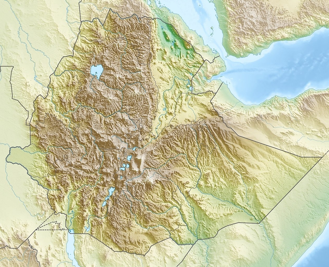
Deutsch: Physische Positionskarte von Äthiopien
Quadratische Plattkarte, N-S-Streckung 102 %. Geographische Begrenzung der Karte:
English: Physical location map of Ethiopia
Equirectangular projection, N/S stretching 102 %. Geographic limits of the map:
|
| ရက်စွဲ | |
| ရင်းမြစ် | ကိုယ်ပိုင်ဖန်တီးမှု, using map data from administrative map by NordNordWest. The relief was created from SRTM-30 relief data |
| စာရေးသူ | Carport |
| ခွင့်ပြုချက် (ဤဖိုင်ကို ပြန်လည်အသုံးပြုခြင်း) |
ဤဖိုင်ကို Creative Commons Attribution-Share Alike 3.0 Unported လိုင်စင်ဖြင့် သတ်မှတ်ထားသည်။
|
| အခြား ဗားရှင်းများ |
|

ဖိုင်မှတ်တမ်း
ဖိုင်ကို ယင်းနေ့စွဲ အတိုင်း မြင်နိုင်ရန် နေ့စွဲ/အချိန် တစ်ခုခုပေါ်တွင် ကလစ်နှိပ်ပါ။
| နေ့စွဲ/အချိန် | နမူနာပုံငယ် | မှတ်တမ်း ဒိုင်မန်းရှင်းများ | အသုံးပြုသူ | မှတ်ချက် | |
|---|---|---|---|---|---|
| ကာလပေါ် | ၁၅:၃၈၊ ၁၃ အောက်တိုဘာ ၂၀၂၁ | | ၁၉၆၆ × ၁၅၉၄ (၇၀၉ KB) | Gebagebo | Added dotted line to indicate Somaliland |
| ၁၃:၅၇၊ ၂၉ စက်တင်ဘာ ၂၀၁၁ |  | ၁၆၃၈ × ၁၃၂၈ (၁.၁၂ MB) | NordNordWest | + South Sudan | |
| ၁၇:၃၂၊ ၁၅ မတ် ၂၀၁၀ |  | ၁၆၃၈ × ၁၃၂၈ (၁.၂၂ MB) | Carport | {{Information |Description={{de|Physische Positionskarte von {{w|Äthiopien|3=de}}}} Quadratische Plattkarte, N-S-Streckung 102 %. Geographische Begrenzung der Karte: * N: 15.3° N * S: 2.9° N * W: 32.7° O * O: 48.3° O {{en|Physical location map of {{w |
ဖိုင်သုံးစွဲမှု
အောက်ပါ 19 စာမျက်နှာများ သည် ဤဖိုင်ကို အသုံးပြုထားသည်:
ဂလိုဘယ် ဖိုင်သုံးစွဲမှု
အောက်ပါ အခြားဝီကီများတွင် ဤဖိုင်ကို အသုံးပြုထားသည်-
- ar.wikipedia.org တွင် အသုံးပြုမှု
- arz.wikipedia.org တွင် အသုံးပြုမှု
- ast.wikipedia.org တွင် အသုံးပြုမှု
- ban.wikipedia.org တွင် အသုံးပြုမှု
- bn.wikipedia.org တွင် အသုံးပြုမှု
- br.wikipedia.org တွင် အသုံးပြုမှု
- bs.wikipedia.org တွင် အသုံးပြုမှု
- ca.wikipedia.org တွင် အသုံးပြုမှု
- ceb.wikipedia.org တွင် အသုံးပြုမှု
- ce.wikipedia.org တွင် အသုံးပြုမှု
- ckb.wikipedia.org တွင် အသုံးပြုမှု
- cs.wikipedia.org တွင် အသုံးပြုမှု
- Ras Dašen
- Adwa (sopka)
- Národní park Simienské hory
- Erta Ale
- Šablona:LocMap Etiopie
- Afdera
- Wikipedie:WikiProjekt Česko-slovenská Wikipedie/Přeložené články/2014-02/Galerie
- Mount Ayalu
- Alajta
- Asavjo
- Alu (sopka)
- Dalaffilla
- Amajtoli Tärara
- Asdaga
- Bilate Šet
- Bishoftu (sopečné pole)
- Boina (fumarolové pole)
- Bora-Bericcio
- Borale Ale
- Borawli
- Boset-Beriča
- Butadžiri-Silti
- Beru
- Corbetti
- Dabbahu
- Dabbajra
- Dallol (sopka)
ဤဖိုင်ကို အခြားနေရာများတွင် အသုံးပြုထားမှုများအား ကြည့်ရှုရန်။