ဖိုင်:Gray Wolf Distribution.gif
ဤနမူနာ၏ အရွယ်အစား - ၈၀၀ × ၂၃၈ ပစ်ဇယ်။ အခြား ပုံရိပ်ပြတ်သားမှု: ၃၂၀ × ၉၅ ပစ်ဇယ် | ၁၁၆၈ × ၃၄၇ ပစ်ဇယ်။
မူရင်းဖိုင် (၁၁၆၈ × ၃၄၇ pixels, ဖိုင်အရွယ်အစား - ၁၇ KB, MIME အမျိုးအစား image/gif)
| ဤဖိုင်သည် Wikimedia Commons မှဖြစ်ပြီး အခြားပရောဂျက်များတွင် သုံးကောင်းသုံးလိမ့်မည်။ ယင်း၏ ဖိုင်အကြောင်းစာမျက်နှာ တွင် ဖော်ပြထားချက်ကို အောက်တွင် ပြထားသည်။ Commons သည် မူပိုင်ခွင့်လွတ်လပ်သော မီဒီယာဖိုင်များ သိုလှောင်ထားရာ နေရာ ဖြစ်သည်။ သင်လည်း ပါဝင်ကူညီနိုင်ပါသည်။ |
အကျဉ်းချုပ်
| ဖော်ပြချက် |
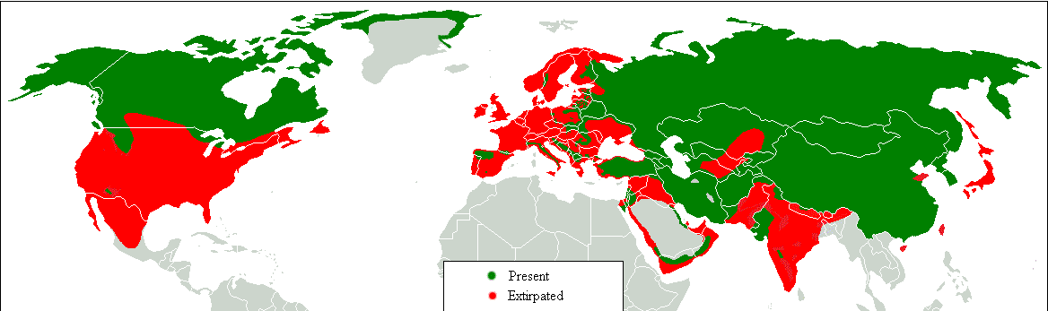
Dansk: Udbredelseskort. Grøn: idag, rød: historisk. English: Range map. Green, present; red, former. Հայերեն: Գայլերի բնակեցման քարտեզ, կանաչ գույնով պատկերված է ներկա արեալը, իսկ կարմիր գույնով՝ պատմական: |
| ရက်စွဲ | |
| ရင်းမြစ် | Transferred from en.wikipedia to Commons.;. |
| စာရေးသူ | Tommyknocker at အင်္ဂလိပ် ဝီကီပီးဒီးယား |

|
This biogeographical map image could be re-created using vector graphics as an SVG file. This has several advantages; see Commons:Media for cleanup for more information. If an SVG form of this image is available, please upload it and afterwards replace this template with
{{vector version available|new image name}}.
It is recommended to name the SVG file “Gray Wolf Distribution.svg”—then the template Vector version available (or Vva) does not need the new image name parameter. |
လိုင်စင်သတ်မှတ်ခြင်း
| This work has been released into the public domain by its author, Tommyknocker at အင်္ဂလိပ် ဝီကီပီးဒီးယား. This applies worldwide. In some countries this may not be legally possible; if so: Tommyknocker grants anyone the right to use this work for any purpose, without any conditions, unless such conditions are required by law. |
မူရင်းတင်ထားသောမှတ်တမ်း
Original description page is/was here(All user names refer to en.wikipedia)
- 2007-03-03 12:04 Tommyknocker 1168×347×8 (16467 bytes)
| Annotations | This image is annotated: View the annotations at Commons |
ဖိုင်မှတ်တမ်း
ဖိုင်ကို ယင်းနေ့စွဲ အတိုင်း မြင်နိုင်ရန် နေ့စွဲ/အချိန် တစ်ခုခုပေါ်တွင် ကလစ်နှိပ်ပါ။
| နေ့စွဲ/အချိန် | နမူနာပုံငယ် | မှတ်တမ်း ဒိုင်မန်းရှင်းများ | အသုံးပြုသူ | မှတ်ချက် | |
|---|---|---|---|---|---|
| ကာလပေါ် | ၀၉:၁၈၊ ၁၇ ဖေဖော်ဝါရီ ၂၀၁၈ | ၁၁၆၈ × ၃၄၇ (၁၇ KB) | William Harris | Refer discussion page - North America | |
| ၀၉:၀၈၊ ၁၆ ဖေဖော်ဝါရီ ၂၀၁၈ | ၁၁၆၈ × ၃၄၇ (၁၇ KB) | William Harris | Refer Discussion page - Caucasus, Turkey and Kyrgyzstan | ||
| ၀၆:၂၉၊ ၁၅ ဖေဖော်ဝါရီ ၂၀၁၈ | ၁၁၆၈ × ၃၄၇ (၁၇ KB) | William Harris | Refer Discussion page - Iran, Pakistan and India | ||
| ၀၅:၅၈၊ ၁၄ ဖေဖော်ဝါရီ ၂၀၁၈ | ၁၁၆၈ × ၃၄၇ (၁၆ KB) | William Harris | Refer Discussion page - India, Nepal, Bhutan, China | ||
| ၁၁:၄၁၊ ၁၃ ဖေဖော်ဝါရီ ၂၀၁၈ | ၁၁၆၈ × ၃၄၇ (၁၆ KB) | William Harris | Amended for both Koreas and all but southern China based on IUNC Red List: http://www.iucnredlist.org/details/3746/0 | ||
| ၁၁:၃၆၊ ၁၂ ဖေဖော်ဝါရီ ၂၀၁၈ | ၁၁၆၈ × ၃၄၇ (၁၆ KB) | William Harris | British Columbia distribution included based on: * https://www.researchgate.net/figure/Map-of-British-Columbia-showing-the-elevation-and-distribution-of-wolf-sampling_fig5_260037025 * http://www.env.gov.bc.ca/fw/wildlife/management-issues/docs/grey_wol... | ||
| ၂၃:၅၅၊ ၉ ဖေဖော်ဝါရီ ၂၀၁၈ | ၁၁၆၈ × ၃၄၇ (၁၆ KB) | Maphobbyist | Complete | ||
| ၂၂:၅၄၊ ၉ ဖေဖော်ဝါရီ ၂၀၁၈ | ၁၁၆၈ × ၃၄၇ (၁၆ KB) | Maphobbyist | Final chck | ||
| ၂၂:၃၈၊ ၉ ဖေဖော်ဝါရီ ၂၀၁၈ | ၁၁၆၈ × ၃၄၇ (၁၆ KB) | Maphobbyist | Again check | ||
| ၂၀:၅၅၊ ၉ ဖေဖော်ဝါရီ ၂၀၁၈ | ၁၁၆၈ × ၃၄၇ (၁၆ KB) | Maphobbyist | Check |
ဖိုင်သုံးစွဲမှု
ဤဖိုင်ကို အသုံးပြုထားသော စာမျက်နှာများမရှိပါ။
ဂလိုဘယ် ဖိုင်သုံးစွဲမှု
အောက်ပါ အခြားဝီကီများတွင် ဤဖိုင်ကို အသုံးပြုထားသည်-
- af.wikipedia.org တွင် အသုံးပြုမှု
- am.wikipedia.org တွင် အသုံးပြုမှု
- azb.wikipedia.org တွင် အသုံးပြုမှု
- bn.wikipedia.org တွင် အသုံးပြုမှု
- bs.wikipedia.org တွင် အသုံးပြုမှု
- cy.wikipedia.org တွင် အသုံးပြုမှု
- de.wikipedia.org တွင် အသုံးပြုမှု
- diq.wikipedia.org တွင် အသုံးပြုမှု
- en.wikipedia.org တွင် အသုံးပြုမှု
- fa.wikipedia.org တွင် အသုံးပြုမှု
- ga.wikipedia.org တွင် အသုံးပြုမှု
- gl.wikipedia.org တွင် အသုံးပြုမှု
- gu.wikipedia.org တွင် အသုံးပြုမှု
- he.wikipedia.org တွင် အသုံးပြုမှု
- hy.wikipedia.org တွင် အသုံးပြုမှု
- hy.wikiquote.org တွင် အသုံးပြုမှု
- ia.wikipedia.org တွင် အသုံးပြုမှု
- ja.wikipedia.org တွင် အသုံးပြုမှု
- kbd.wikipedia.org တွင် အသုံးပြုမှု
- ko.wikipedia.org တွင် အသုံးပြုမှု
- ku.wikipedia.org တွင် အသုံးပြုမှု
- lb.wikipedia.org တွင် အသုံးပြုမှု
- mk.wikipedia.org တွင် အသုံးပြုမှု
- mn.wikipedia.org တွင် အသုံးပြုမှု
- ms.wikipedia.org တွင် အသုံးပြုမှု
- myv.wikipedia.org တွင် အသုံးပြုမှု
- ne.wikipedia.org တွင် အသုံးပြုမှု
- oc.wikipedia.org တွင် အသုံးပြုမှု
- pa.wikipedia.org တွင် အသုံးပြုမှု
- ro.wikipedia.org တွင် အသုံးပြုမှု
- ru.wikipedia.org တွင် အသုံးပြုမှု
- so.wikipedia.org တွင် အသုံးပြုမှု
- stq.wikipedia.org တွင် အသုံးပြုမှု
- sv.wikipedia.org တွင် အသုံးပြုမှု
- ta.wikipedia.org တွင် အသုံးပြုမှု
- tl.wikipedia.org တွင် အသုံးပြုမှု
- zh-min-nan.wikipedia.org တွင် အသုံးပြုမှု
- zh-yue.wikipedia.org တွင် အသုံးပြုမှု