ဖိုင်:Guadeloupe - Location Map (2013) - GLP - UNOCHA.svg

မူရင်းဖိုင် (SVG ဖိုင်, ၂၅၀ × ၂၅၀ pixels ကို အကြံပြုသည်, ဖိုင်အရွယ်အစား - ၂၆၃ KB)
| ဤဖိုင်သည် Wikimedia Commons မှဖြစ်ပြီး အခြားပရောဂျက်များတွင် သုံးကောင်းသုံးလိမ့်မည်။ ယင်း၏ ဖိုင်အကြောင်းစာမျက်နှာ တွင် ဖော်ပြထားချက်ကို အောက်တွင် ပြထားသည်။ Commons သည် မူပိုင်ခွင့်လွတ်လပ်သော မီဒီယာဖိုင်များ သိုလှောင်ထားရာ နေရာ ဖြစ်သည်။ သင်လည်း ပါဝင်ကူညီနိုင်ပါသည်။ |
_-_GLP_-_UNOCHA.svg)
အကျဉ်းချုပ်
| ဖော်ပြချက် |
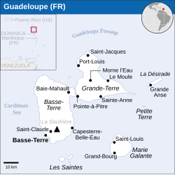
English: Locator map of Guadeloupe. |
| ရက်စွဲ | |
| ရင်းမြစ် |
English: Guadeloupe (France) Locator Map (ReliefWeb), ESRI, UNCS, Natural Earth, The Times Atlas of the World |
| စာရေးသူ | |
| SVG genesis | ဤ SVG ၏ ကုဒ်သည် ခိုင်လုံသည်။ |
လိုင်စင်သတ်မှတ်ခြင်း
- သင်သည် လွတ်လပ်စွာ:
- မျှဝေရန် – ဖန်တီးမှုကို ကူးယူရန်၊ ဖြန့်ဖြူးရန်နှင့် ထုတ်လွှင့်ရန်
- ပြန်ရောနှောရန် – ဖန်တီးမှုကို ပြင်ဆင်ညှိနှိုင်းရန်
- အောက်ပါ အခြေအနေများတွင်:
- မှတ်ယူနိုင်ခြင်း – ပြောင်းလဲမှုများ ပြုလုပ်ခဲ့ပါက ဖန်တီးသူ သို့မဟုတ် လိုင်စင်ရှိသူမှ သတ်မှတ်သော အမျိုးအစားကို လိုက်နာရမည် (ဆိုလိုသည်မှာ သင့်အား သို့မဟုတ် သင့်ဖန်တီးမှုတွင် အသုံးပြုခြင်းအား ထောက်ခံချက်ပေးသည်ဟု မဆိုလိုပါ)။
 This map is part of a collection of 216 free country maps, created by the UN Office for the Coordination of Humanitarian Affairs (OCHA), to be used in print, web or broadcast products.
The ReliefWeb Location Maps released here are maps that highlight a country, its capital, major populated places and the surrounding regions. Attribution Requirements
Using the map without modifications: ensure that the sources and the disclaimer are below the map. Credit as follows: "Credit: OCHA". For use with alteration: remove the OCHA logo and disclaimer following any modification to the map, but keep the data sources as mentioned below the map. Credit the modified map as follows: "Based on OCHA map". You are responsible for the content of your map. We are keen to receive your feedback and hear how you used OCHA's maps. We would be grateful if you would notify us by e-mail and share your work with us. UN Disclaimer
The designations employed and the presentation of material of this map do not imply the expression of any opinion whatsoever on the part of the Secretariat of the United Nations concerning the legal status of any country, territory, city or area or of its authorities or concerning the delimitation of its frontiers or boundaries. |
ဖိုင်မှတ်တမ်း
ဖိုင်ကို ယင်းနေ့စွဲ အတိုင်း မြင်နိုင်ရန် နေ့စွဲ/အချိန် တစ်ခုခုပေါ်တွင် ကလစ်နှိပ်ပါ။
| နေ့စွဲ/အချိန် | နမူနာပုံငယ် | မှတ်တမ်း ဒိုင်မန်းရှင်းများ | အသုံးပြုသူ | မှတ်ချက် | |
|---|---|---|---|---|---|
| ကာလပေါ် | ၀၉:၅၇၊ ၁၀ စက်တင်ဘာ ၂၀၁၆ | | ၂၅၀ × ၂၅၀ (၂၆၃ KB) | Wereldburger758 | Resized page to drawing. Removal watermark. Validation of image. |
| ၀၁:၂၇၊ ၂၁ ဧပြီ ၂၀၁၄ |  | ၂၅၄ × ၂၅၄ (၂၈၈ KB) | UN OCHA maps bot | == {{int:filedesc}} == {{Information |description={{en|1=Locator map of Guadeloupe.}} |date=2013 |source={{en|1=[http://reliefweb.int/map/guadeloupe-france/guadaloupe-fr-location-map-2013 Guadeloupe (France) Locator Map (ReliefWeb)]... |
ဖိုင်သုံးစွဲမှု
အောက်ပါ စာမျက်နှာ သည် ဤဖိုင်ကို အသုံးပြုထားသည်:
ဂလိုဘယ် ဖိုင်သုံးစွဲမှု
အောက်ပါ အခြားဝီကီများတွင် ဤဖိုင်ကို အသုံးပြုထားသည်-
- en.wikipedia.org တွင် အသုံးပြုမှု
- fr.wikipedia.org တွင် အသုံးပြုမှု
- io.wikipedia.org တွင် အသုံးပြုမှု
- lt.wikipedia.org တွင် အသုံးပြုမှု
- mk.wikipedia.org တွင် အသုံးပြုမှု
- ml.wikipedia.org တွင် အသုံးပြုမှု
- mr.wikipedia.org တွင် အသုံးပြုမှု
_-_GLP_-_UNOCHA.svg)