ဖိုင်:Gulf of Thailand.svg

Size of this PNG preview of this SVG file: ၄၈၈ × ၄၇၉ ပစ်ဇယ်. အခြား ပုံရိပ်ပြတ်သားမှု: ၂၄၅ × ၂၄၀ ပစ်ဇယ် | ၄၈၉ × ၄၈၀ ပစ်ဇယ် | ၇၈၂ × ၇၆၈ ပစ်ဇယ် | ၁၀၄၃ × ၁၀၂၄ ပစ်ဇယ် | ၂၀၈၆ × ၂၀၄၈ ပစ်ဇယ်။
မူရင်းဖိုင် (SVG ဖိုင်, ၄၈၈ × ၄၇၉ pixels ကို အကြံပြုသည်, ဖိုင်အရွယ်အစား - ၃၈၇ KB)
| ဤဖိုင်သည် Wikimedia Commons မှဖြစ်ပြီး အခြားပရောဂျက်များတွင် သုံးကောင်းသုံးလိမ့်မည်။ ယင်း၏ ဖိုင်အကြောင်းစာမျက်နှာ တွင် ဖော်ပြထားချက်ကို အောက်တွင် ပြထားသည်။ Commons သည် မူပိုင်ခွင့်လွတ်လပ်သော မီဒီယာဖိုင်များ သိုလှောင်ထားရာ နေရာ ဖြစ်သည်။ သင်လည်း ပါဝင်ကူညီနိုင်ပါသည်။ |
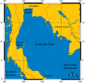
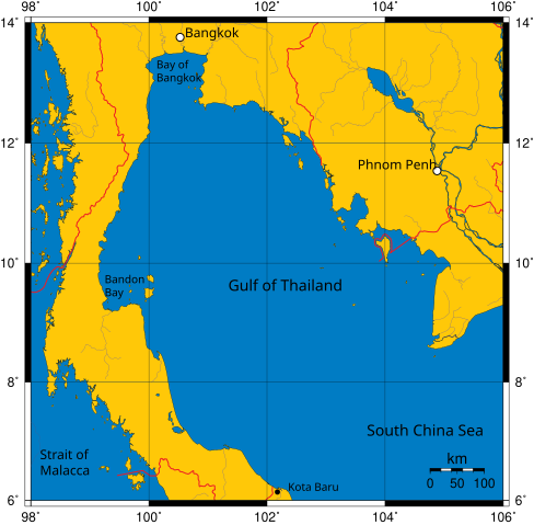
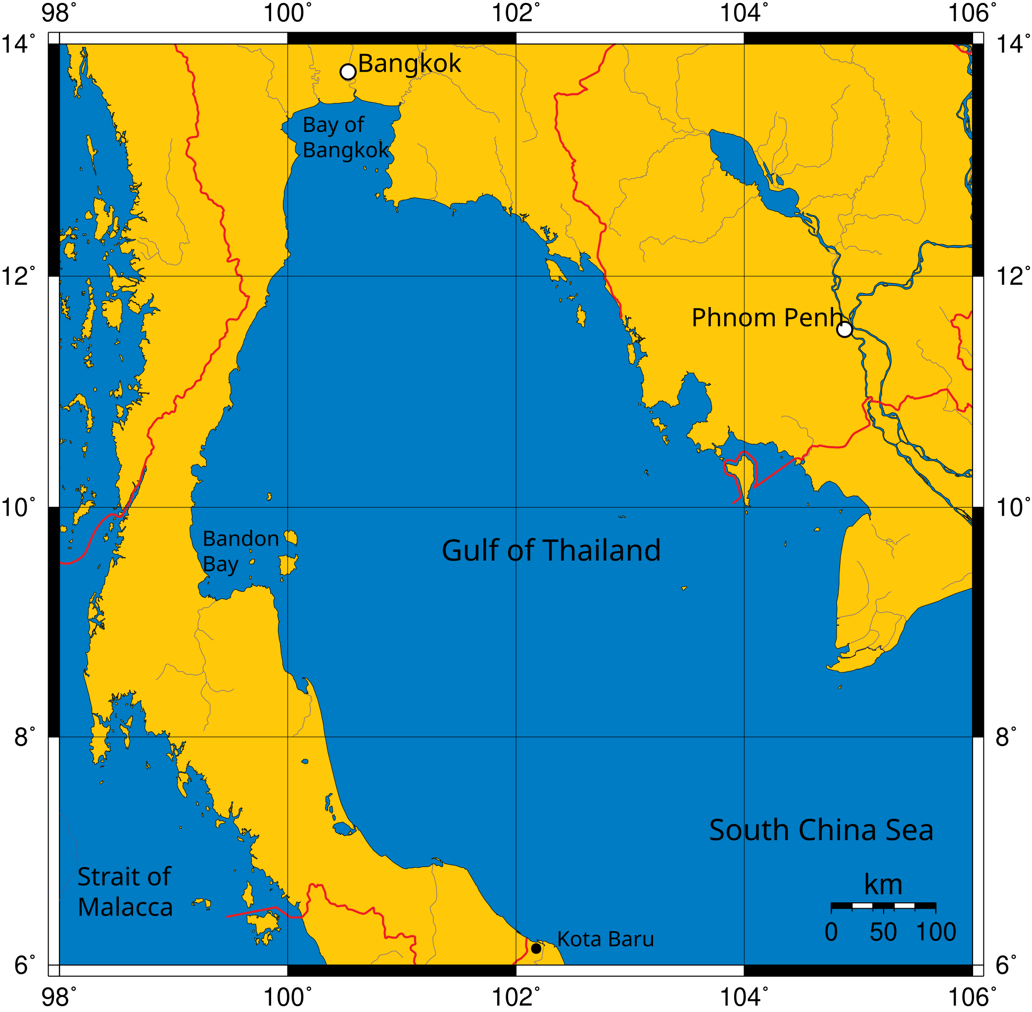
Mercator projection of Gulf of Thailand.
Public Domain map created by Online Map Creation:
http://www.aquarius.geomar.de/omc/omc_intro.html archive copy at the Wayback Machine
Modified by me (User:Feydey).
Other versions
-
 Italiano
 -
 Македонски
 -
 বাংলা
বাংলা


| This work has been released into the public domain by its author, User:Feydey. This applies worldwide. In some countries this may not be legally possible; if so: User:Feydey grants anyone the right to use this work for any purpose, without any conditions, unless such conditions are required by law.
|
derivative works
Derivative works of this file:
ဖိုင်မှတ်တမ်း
ဖိုင်ကို ယင်းနေ့စွဲ အတိုင်း မြင်နိုင်ရန် နေ့စွဲ/အချိန် တစ်ခုခုပေါ်တွင် ကလစ်နှိပ်ပါ။
| နေ့စွဲ/အချိန် | နမူနာပုံငယ် | မှတ်တမ်း ဒိုင်မန်းရှင်းများ | အသုံးပြုသူ | မှတ်ချက် | |
|---|---|---|---|---|---|
| ကာလပေါ် | ၁၁:၀၆၊ ၁၆ ဇန်နဝါရီ ၂၀၂၀ | | ၄၈၈ × ၄၇၉ (၃၈၇ KB) | Paul 012 | The label "Andaman Sea" was in the area officially defined as the Strait of Malacca. |
| ၁၇:၅၃၊ ၂၇ ဇွန် ၂၀၀၇ |  | ၄၈၈ × ၄၇၉ (၃၈၇ KB) | Feydey | Mercator projection of Gulf of Thailand. Public Domain map created by Online Map Creation: http://www.aquarius.geomar.de/omc/omc_intro.html Modified by me (User:Feydey). {{PD}} Category:Maps of seas |
ဖိုင်သုံးစွဲမှု
အောက်ပါ စာမျက်နှာ သည် ဤဖိုင်ကို အသုံးပြုထားသည်:
ဂလိုဘယ် ဖိုင်သုံးစွဲမှု
အောက်ပါ အခြားဝီကီများတွင် ဤဖိုင်ကို အသုံးပြုထားသည်-
- af.wikipedia.org တွင် အသုံးပြုမှု
- azb.wikipedia.org တွင် အသုံးပြုမှု
- br.wikipedia.org တွင် အသုံးပြုမှု
- ca.wikipedia.org တွင် အသုံးပြုမှု
- ckb.wikipedia.org တွင် အသုံးပြုမှု
- da.wikipedia.org တွင် အသုံးပြုမှု
- de.wikinews.org တွင် အသုံးပြုမှု
- el.wikipedia.org တွင် အသုံးပြုမှု
- en.wikipedia.org တွင် အသုံးပြုမှု
- fa.wikipedia.org တွင် အသုံးပြုမှု
- fi.wikipedia.org တွင် အသုံးပြုမှု
- fr.wikipedia.org တွင် အသုံးပြုမှု
- hi.wikipedia.org တွင် အသုံးပြုမှု
- hu.wikipedia.org တွင် အသုံးပြုမှု
- ilo.wikipedia.org တွင် အသုံးပြုမှု
- io.wikipedia.org တွင် အသုံးပြုမှု
- ja.wikipedia.org တွင် အသုံးပြုမှု
- ka.wikipedia.org တွင် အသုံးပြုမှု
- km.wikipedia.org တွင် အသုံးပြုမှု
- ko.wikipedia.org တွင် အသုံးပြုမှု
- la.wikipedia.org တွင် အသုံးပြုမှု
- lo.wikipedia.org တွင် အသုံးပြုမှု
- min.wikipedia.org တွင် အသုံးပြုမှု
- ml.wikipedia.org တွင် အသုံးပြုမှု
- mr.wikipedia.org တွင် အသုံးပြုမှု
- ms.wikipedia.org တွင် အသုံးပြုမှု
- mt.wikipedia.org တွင် အသုံးပြုမှု
- nn.wikipedia.org တွင် အသုံးပြုမှု
- pa.wikipedia.org တွင် အသုံးပြုမှု
- pnb.wikipedia.org တွင် အသုံးပြုမှု
- simple.wikipedia.org တွင် အသုံးပြုမှု
- sr.wikipedia.org တွင် အသုံးပြုမှု
- sv.wikipedia.org တွင် အသုံးပြုမှု
- sw.wikipedia.org တွင် အသုံးပြုမှု
- ta.wikipedia.org တွင် အသုံးပြုမှု
- th.wikipedia.org တွင် အသုံးပြုမှု
- tl.wikipedia.org တွင် အသုံးပြုမှု
- tr.wikipedia.org တွင် အသုံးပြုမှု
- uk.wikipedia.org တွင် အသုံးပြုမှု
- ur.wikipedia.org တွင် အသုံးပြုမှု
- vi.wikipedia.org တွင် အသုံးပြုမှု
- war.wikipedia.org တွင် အသုံးပြုမှု
- xmf.wikipedia.org တွင် အသုံးပြုမှု
ဤဖိုင်ကို အခြားနေရာများတွင် အသုံးပြုထားမှုများအား ကြည့်ရှုရန်။