ဖိုင်:Hong Kong Location.svg

Size of this PNG preview of this SVG file: ၈၀၀ × ၄၀၃ ပစ်ဇယ်. အခြား ပုံရိပ်ပြတ်သားမှု: ၃၂၀ × ၁၆၁ ပစ်ဇယ် | ၆၄၀ × ၃၂၃ ပစ်ဇယ် | ၁၀၂၄ × ၅၁၆ ပစ်ဇယ် | ၁၂၈၀ × ၆၄၅ ပစ်ဇယ် | ၂၅၆၀ × ၁၂၉၀ ပစ်ဇယ် | ၁၂၇၀ × ၆၄၀ ပစ်ဇယ်။
မူရင်းဖိုင် (SVG ဖိုင်, ၁၂၇၀ × ၆၄၀ pixels ကို အကြံပြုသည်, ဖိုင်အရွယ်အစား - ၂၂၉ KB)
| ဤဖိုင်သည် Wikimedia Commons မှဖြစ်ပြီး အခြားပရောဂျက်များတွင် သုံးကောင်းသုံးလိမ့်မည်။ ယင်း၏ ဖိုင်အကြောင်းစာမျက်နှာ တွင် ဖော်ပြထားချက်ကို အောက်တွင် ပြထားသည်။ Commons သည် မူပိုင်ခွင့်လွတ်လပ်သော မီဒီယာဖိုင်များ သိုလှောင်ထားရာ နေရာ ဖြစ်သည်။ သင်လည်း ပါဝင်ကူညီနိုင်ပါသည်။ |
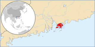
| ဖော်ပြချက် | A map showing Hong Kong's location in Asia on China's south coast. | ||
| ရက်စွဲ | |||
| ရင်းမြစ် | ကိုယ်ပိုင်ဖန်တီးမှု | ||
| စာရေးသူ | Joowwww | ||
| ခွင့်ပြုချက် (ဤဖိုင်ကို ပြန်လည်အသုံးပြုခြင်း) |
|
||
| အခြား ဗားရှင်းများ |
Derivative works of this file: |
This W3C-unspecified vector image was created with Inkscape .
ဖိုင်မှတ်တမ်း
ဖိုင်ကို ယင်းနေ့စွဲ အတိုင်း မြင်နိုင်ရန် နေ့စွဲ/အချိန် တစ်ခုခုပေါ်တွင် ကလစ်နှိပ်ပါ။
| နေ့စွဲ/အချိန် | နမူနာပုံငယ် | မှတ်တမ်း ဒိုင်မန်းရှင်းများ | အသုံးပြုသူ | မှတ်ချက် | |
|---|---|---|---|---|---|
| ကာလပေါ် | ၁၃:၂၇၊ ၂၇ ဩဂုတ် ၂၀၀၈ | | ၁၂၇၀ × ၆၄၀ (၂၂၉ KB) | Joowwww | a few minor tweaks |
| ၁၃:၁၈၊ ၂၇ ဩဂုတ် ၂၀၀၈ |  | ၁၂၇၀ × ၆၄၀ (၂၂၉ KB) | Joowwww | new version: more detailed, colours are standard with most other locator maps | |
| ၁၃:၅၄၊ ၂၀ ဧပြီ ၂၀၀၈ |  | ၁၂၇၀ × ၆၄၀ (၇၈ KB) | Joowwww | reduced height, removed map border and added rivers and hk's maritime border | |
| ၁၁:၃၁၊ ၉ ဧပြီ ၂၀၀၈ |  | ၁၂၇၀ × ၉၇၇ (၆၅ KB) | Joowwww | {{Information |Description=A map showing Hong Kong's location in Asia, in China and on China's south coast. |Source=self-made |Date=2008-04-09 |Author= Joowwww |Permission={{PD-self}} |other_versions= }} {{Created with Inkscape}} [[Categ |
ဖိုင်သုံးစွဲမှု
အောက်ပါ စာမျက်နှာ သည် ဤဖိုင်ကို အသုံးပြုထားသည်:
ဂလိုဘယ် ဖိုင်သုံးစွဲမှု
အောက်ပါ အခြားဝီကီများတွင် ဤဖိုင်ကို အသုံးပြုထားသည်-
- ace.wikipedia.org တွင် အသုံးပြုမှု
- af.wikipedia.org တွင် အသုံးပြုမှု
- am.wikipedia.org တွင် အသုံးပြုမှု
- awa.wikipedia.org တွင် အသုံးပြုမှု
- bs.wikipedia.org တွင် အသုံးပြုမှု
- ca.wikipedia.org တွင် အသုံးပြုမှု
- cdo.wikipedia.org တွင် အသုံးပြုမှု
- cs.wikipedia.org တွင် အသုံးပြုမှု
- da.wikipedia.org တွင် အသုံးပြုမှု
- el.wikipedia.org တွင် အသုံးပြုမှု
- en.wikipedia.org တွင် အသုံးပြုမှု
- eo.wikipedia.org တွင် အသုံးပြုမှု
- es.wikinews.org တွင် အသုံးပြုမှု
- fa.wikipedia.org တွင် အသုံးပြုမှု
- fo.wikipedia.org တွင် အသုံးပြုမှု
- fr.wikipedia.org တွင် အသုံးပြုမှု
- gag.wikipedia.org တွင် အသုံးပြုမှု
- gu.wikipedia.org တွင် အသုံးပြုမှု
- hak.wikipedia.org တွင် အသုံးပြုမှု
- hi.wikipedia.org တွင် အသုံးပြုမှု
- ig.wikipedia.org တွင် အသုံးပြုမှု
- ilo.wikipedia.org တွင် အသုံးပြုမှု
- incubator.wikimedia.org တွင် အသုံးပြုမှု
- it.wikipedia.org တွင် အသုံးပြုမှု
- jam.wikipedia.org တွင် အသုံးပြုမှု
- kaa.wikipedia.org တွင် အသုံးပြုမှု
- km.wikipedia.org တွင် အသုံးပြုမှု
- kn.wikipedia.org တွင် အသုံးပြုမှု
- ko.wikinews.org တွင် အသုံးပြုမှု
- kw.wikipedia.org တွင် အသုံးပြုမှု
- lv.wikipedia.org တွင် အသုံးပြုမှု
- ml.wikipedia.org တွင် အသုံးပြုမှု
- mr.wikipedia.org တွင် အသုံးပြုမှု
- ms.wikipedia.org တွင် အသုံးပြုမှု
- nl.wikipedia.org တွင် အသုံးပြုမှု
ဤဖိုင်ကို အခြားနေရာများတွင် အသုံးပြုထားမှုများအား ကြည့်ရှုရန်။