ဖိုင်:India Karnataka location map.svg

Size of this PNG preview of this SVG file: ၄၂၃ × ၆၀၀ ပစ်ဇယ်. အခြား ပုံရိပ်ပြတ်သားမှု: ၁၆၉ × ၂၄၀ ပစ်ဇယ် | ၃၃၈ × ၄၈၀ ပစ်ဇယ် | ၅၄၂ × ၇၆၈ ပစ်ဇယ် | ၇၂၂ × ၁၀၂၄ ပစ်ဇယ် | ၁၄၄၅ × ၂၀၄၈ ပစ်ဇယ် | ၈၉၈ × ၁၂၇၃ ပစ်ဇယ်။
မူရင်းဖိုင် (SVG ဖိုင်, ၈၉၈ × ၁၂၇၃ pixels ကို အကြံပြုသည်, ဖိုင်အရွယ်အစား - ၇၅၉ KB)
| ဤဖိုင်သည် Wikimedia Commons မှဖြစ်ပြီး အခြားပရောဂျက်များတွင် သုံးကောင်းသုံးလိမ့်မည်။ ယင်း၏ ဖိုင်အကြောင်းစာမျက်နှာ တွင် ဖော်ပြထားချက်ကို အောက်တွင် ပြထားသည်။ Commons သည် မူပိုင်ခွင့်လွတ်လပ်သော မီဒီယာဖိုင်များ သိုလှောင်ထားရာ နေရာ ဖြစ်သည်။ သင်လည်း ပါဝင်ကူညီနိုင်ပါသည်။ |
| ဖော်ပြချက် |
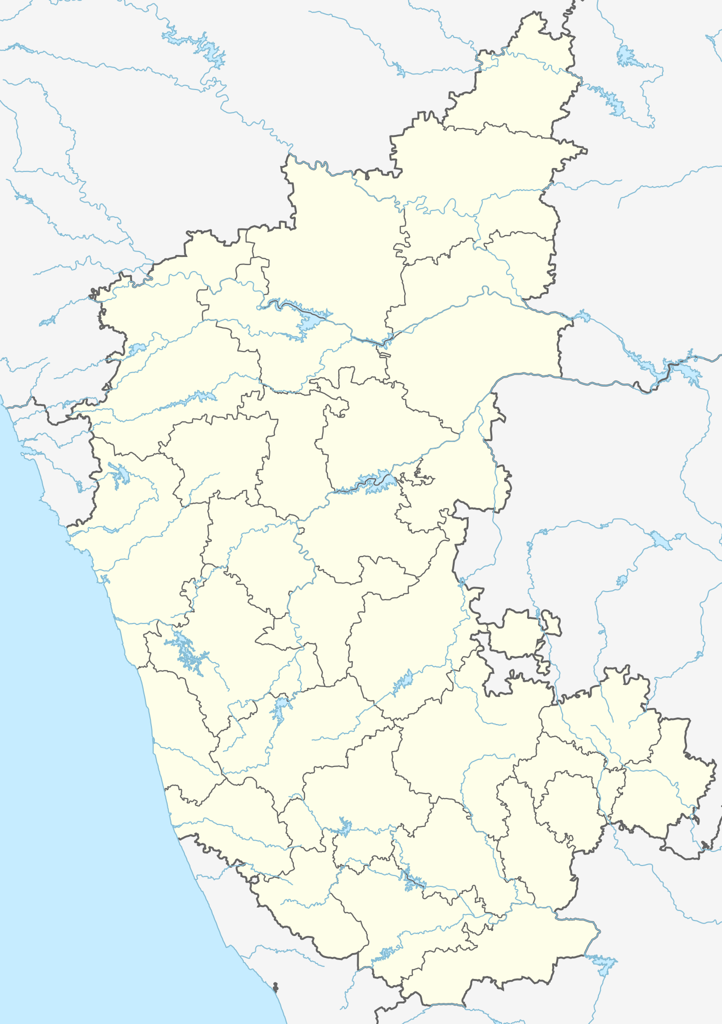
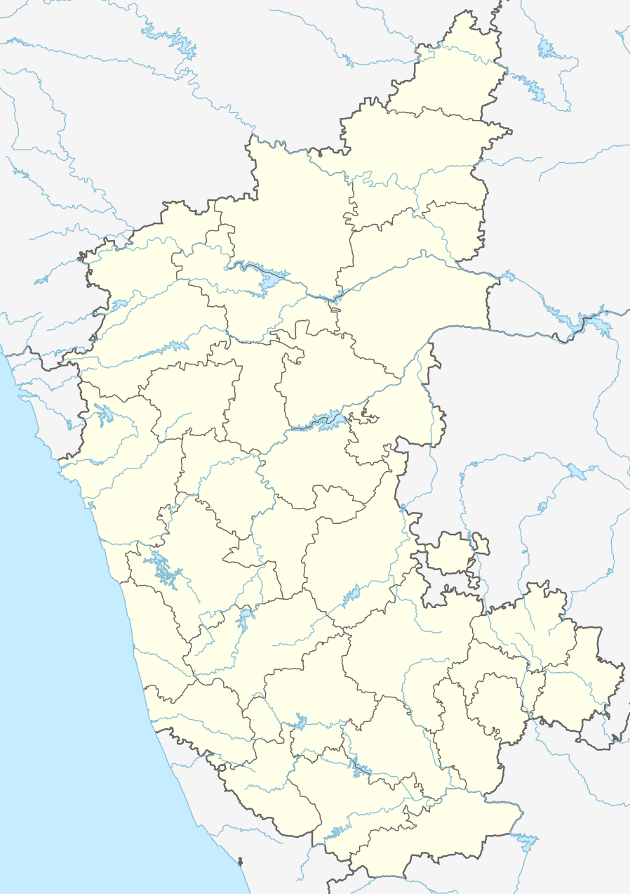
Location map of Karnataka Geographic limits of the map:
|
| ရက်စွဲ | (UTC) |
| ရင်းမြစ် | |
| စာရေးသူ |
|
| အခြား ဗားရှင်းများ |
Derivative works of this file: |
| This is a retouched picture, which means that it has been digitally altered from its original version. Modifications: Created 3 new districts Chikkaballapur, Ramanagara and Yadgir. Changed conventions per WP:WPMAP. The original can be viewed here: Karnataka locator map.svg:
|
ဤဖိုင်ကို Creative Commons Attribution-Share Alike 3.0 Unported လိုင်စင်ဖြင့် သတ်မှတ်ထားသည်။
- သင်သည် လွတ်လပ်စွာ:
- မျှဝေရန် – ဖန်တီးမှုကို ကူးယူရန်၊ ဖြန့်ဖြူးရန်နှင့် ထုတ်လွှင့်ရန်
- ပြန်ရောနှောရန် – ဖန်တီးမှုကို ပြင်ဆင်ညှိနှိုင်းရန်
- အောက်ပါ အခြေအနေများတွင်:
- မှတ်ယူနိုင်ခြင်း – ပြောင်းလဲမှုများ ပြုလုပ်ခဲ့ပါက ဖန်တီးသူ သို့မဟုတ် လိုင်စင်ရှိသူမှ သတ်မှတ်သော အမျိုးအစားကို လိုက်နာရမည် (ဆိုလိုသည်မှာ သင့်အား သို့မဟုတ် သင့်ဖန်တီးမှုတွင် အသုံးပြုခြင်းအား ထောက်ခံချက်ပေးသည်ဟု မဆိုလိုပါ)။
- ထပ်တူမျှဝေ – ဤဖန်တီးမှုအား ပြင်ဆင်ခြင်း၊ ပြောင်းလဲခြင်း သို့မဟုတ် ထပ်ဆင့် ဖန်တီးခြင်း ပြုလုပ်ပါက ရရှိလာသော ဖန်တီးမှုကို ဤဖန်တီးမှုနှင့် သို့မဟုတ် ဆင်တူသော လိုင်စင်ဖြင့်သာ ဖြန့်ချိသင့်သည်။
မူရင်းတင်ထားသောမှတ်တမ်း
This image is a derivative work of the following images:
- File:Karnataka_locator_map.svg licensed with Cc-by-sa-3.0
- 2007-05-06T13:55:02Z Planemad 1630x2356 (231773 Bytes) {{WikiProject_India_Maps |Title=Karnataka locator Map |Description=Map of [[w:Karnataka]] with road and rail lines |Source= [http://aquarium.lipetsk.ru/discovery/India2004/karnataka-map.jpg Karnataka Map], [http://www.indianr
Uploaded with derivativeFX
ဖိုင်မှတ်တမ်း
ဖိုင်ကို ယင်းနေ့စွဲ အတိုင်း မြင်နိုင်ရန် နေ့စွဲ/အချိန် တစ်ခုခုပေါ်တွင် ကလစ်နှိပ်ပါ။
| နေ့စွဲ/အချိန် | နမူနာပုံငယ် | မှတ်တမ်း ဒိုင်မန်းရှင်းများ | အသုံးပြုသူ | မှတ်ချက် | |
|---|---|---|---|---|---|
| ကာလပေါ် | ၀၃:၁၀၊ ၁၆ ဇွန် ၂၀၂၃ | | ၈၉၈ × ၁၂၇၃ (၇၅၉ KB) | C1MM | c Vijayanagara district |
| ၀၄:၄၁၊ ၁၃ ဩဂုတ် ၂၀၂၁ |  | ၈၅၁ × ၁၂၁၁ (၅၈၂ KB) | C1MM | Added more rivers | |
| ၀၃:၃၃၊ ၁၆ ဇူလိုင် ၂၀၂၁ |  | ၈၅၁ × ၁၂၁၁ (၅၆၁ KB) | C1MM | Added more accurate district boundaries | |
| ၂၃:၄၁၊ ၁၄ ဒီဇင်ဘာ ၂၀၂၀ |  | ၁၆၃၄ × ၂၃၆၇ (၃၄၁ KB) | C1MM | Fixed boundaries of Vijayanagara district | |
| ၂၂:၁၀၊ ၁၄ ဒီဇင်ဘာ ၂၀၂၀ |  | ၁၆၃၄ × ၂၃၆၇ (၃၄၅ KB) | C1MM | Added boundaries of AP/Telangana and rivers | |
| ၁၉:၂၆၊ ၁၃ ဒီဇင်ဘာ ၂၀၂၀ |  | ၁၆၃၄ × ၂၃၆၇ (၃၄၂ KB) | C1MM | Fixed district boundaries of Ballari and added Vijayanagara district | |
| ၀၃:၅၃၊ ၂၁ ဧပြီ ၂၀၂၀ |  | ၁၆၃၄ × ၂၃၆၇ (၂၈၉ KB) | C1MM | Added rivers | |
| ၁၅:၅၀၊ ၁၅ နိုဝင်ဘာ ၂၀၁၀ |  | ၁၆၃၀ × ၂၃၅၆ (၂၀၇ KB) | Nayvik | Changed background color | |
| ၁၅:၃၄၊ ၁၅ နိုဝင်ဘာ ၂၀၁၀ |  | ၁၆၃၀ × ၂၃၅၆ (၂၀၆ KB) | Nayvik | {{Information |Description=Location map of Karnataka Geographic limits of the map: * 18.5°N * 11.0°N * 73.6°E * 78.7°E |Source=*File:Karnataka_locator_map.svg, [http://www.censusindia.gov.in/2011-Images/ADMINI2011.jpg Census In |
ဖိုင်သုံးစွဲမှု
အောက်ပါ 3 စာမျက်နှာများ သည် ဤဖိုင်ကို အသုံးပြုထားသည်:
ဂလိုဘယ် ဖိုင်သုံးစွဲမှု
အောက်ပါ အခြားဝီကီများတွင် ဤဖိုင်ကို အသုံးပြုထားသည်-
- ar.wikipedia.org တွင် အသုံးပြုမှု
- as.wikipedia.org တွင် အသုံးပြုမှု
- azb.wikipedia.org တွင် အသုံးပြုမှု
- تومکور
- بنقلور
- عباسی، کارناتاکا
- اودقولام
- پیکلیهال
- اوداجی (هیندوستان)
- اوچیلا, اودوپی دیستریکت
- اوچاواد
- او خاناپور
- ویراهانوماکاناپالیا
- فاجیر (هیندوستان)
- پتالور (هیندوستان)
- پت آماپور
- ویراکامبا
- ویراپور
- وانور (هیندوستان)
- ساتیجری
- ساتانور, ماقادی
- ساتانور, بانقالور
- ساسالاتی
- سارقور
- ساراواد
- ساراپادی
- ساپتاساقار
- سانتور
- سانتکاسالاجر
- مایاکوندا
- ساناتی
- ماویناکر
- ماوالی
- ماتیواد
- کالادکا
- سانیکاتا
- کالکونت
- کالکری
- ماتماری
- سانقاناهالا
- کالجی (هیندوستان)
- سانقامشوارا, کالاقاتاجی
- ماتاداکوروباراهاتی
- ماستیهولی
- کالاسا, کوندقول
- ماسارکال
- ماسابینال
ဤဖိုင်ကို အခြားနေရာများတွင် အသုံးပြုထားမှုများအား ကြည့်ရှုရန်။