ဖိုင်:Kyivan Rus' 1220-1240.png

ဤနမူနာ၏ အရွယ်အစား - ၄၈၃ × ၅၉၉ ပစ်ဇယ်။ အခြား ပုံရိပ်ပြတ်သားမှု: ၁၉၃ × ၂၄၀ ပစ်ဇယ် | ၃၈၇ × ၄၈၀ ပစ်ဇယ် | ၆၁၉ × ၇၆၈ ပစ်ဇယ် | ၈၂၅ × ၁၀၂၄ ပစ်ဇယ် | ၂၃၀၁ × ၂၈၅၆ ပစ်ဇယ်။
မူရင်းဖိုင် (၂၃၀၁ × ၂၈၅၆ pixels, ဖိုင်အရွယ်အစား - ၆.၁ MB, MIME အမျိုးအစား image/png)
| ဤဖိုင်သည် Wikimedia Commons မှဖြစ်ပြီး အခြားပရောဂျက်များတွင် သုံးကောင်းသုံးလိမ့်မည်။ ယင်း၏ ဖိုင်အကြောင်းစာမျက်နှာ တွင် ဖော်ပြထားချက်ကို အောက်တွင် ပြထားသည်။ Commons သည် မူပိုင်ခွင့်လွတ်လပ်သော မီဒီယာဖိုင်များ သိုလှောင်ထားရာ နေရာ ဖြစ်သည်။ သင်လည်း ပါဝင်ကူညီနိုင်ပါသည်။ |
အကျဉ်းချုပ်
| ဖော်ပြချက် |
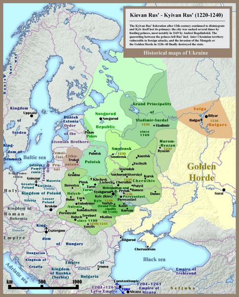
English: Historical map of Kievan Rus' and territory of Ukraine: last 20 years of the state (1220-1240), english version. |
| ရက်စွဲ | |
| ရင်းမြစ် | ကိုယ်ပိုင်ဖန်တီးမှု - Other example of similar map: http://izbornyk.org.ua/litop/map_1240.htm |
| စာရေးသူ | SeikoEn, overworked and reloaded by Ulamm (talk) 22:42, 30 April 2014 (UTC) |
| အခြား ဗားရှင်းများ | File:001 Kievan Rus' Kyivan Rus' Ukraine map 1220 1240.jpg |
လိုင်စင်သတ်မှတ်ခြင်း
ကျွန်ုပ်၊ ဤလုပ်ဆောင်ချက်၏ မူပိုင်ခွင့်ပိုင်ရှင်အနေဖြင့် ဤနေရာမှ အောက်ပါလိုင်စင်များအောက်တွင် ထုတ်လွှင့်ပါသည်:

|
ဤစာတမ်းကို GNU Free Documentation License, ဗားရှင်း ၁.၂ သို့မဟုတ် Free Software Foundation မှ ဖြန့်ချီထားသော မည်သည့်ယခင်ဗားရှင်းတစ်ခုခုအောက်တွင် Invariant Sections, Front-Cover Texts နှင့် Back-Cover Texts များမပါဝင်ဘဲ ကူးယူခြင်း၊ ဖြန့်ချီခြင်း နှင့်/သို့မဟုတ် ပြင်ဆင်ပြောင်းလဲနိုင်ရန် ခွင့်ပြုသည်။ လိုင်စင်မူပွားကို GNU Free Documentation License ခေါင်းစဉ်အောက်တွင် ထည့်သွင်းထားသည်။ |
| ဤဖိုင်ကို Creative Commons Attribution-Share Alike 3.0 Unported လိုင်စင်ဖြင့် သတ်မှတ်ထားသည်။ | ||
| ||
| This licensing tag was added to this file as part of the GFDL licensing update. |
သင်အလိုရှိရာ လိုင်စင်ကို ရွေးချယ်နိုင်ပါသည်။
ဖိုင်မှတ်တမ်း
ဖိုင်ကို ယင်းနေ့စွဲ အတိုင်း မြင်နိုင်ရန် နေ့စွဲ/အချိန် တစ်ခုခုပေါ်တွင် ကလစ်နှိပ်ပါ။
| နေ့စွဲ/အချိန် | နမူနာပုံငယ် | မှတ်တမ်း ဒိုင်မန်းရှင်းများ | အသုံးပြုသူ | မှတ်ချက် | |
|---|---|---|---|---|---|
| ကာလပေါ် | ၁၆:၅၉၊ ၃၀ နိုဝင်ဘာ ၂၀၂၃ | | ၂၃၀၁ × ၂၈၅၆ (၆.၁ MB) | X3qt | Reverted to version as of 17:28, 18 July 2014 (UTC), Vilnius did not existed in period covered by the map, Duchy of Lithuania was a vassal to Grand Duchy of Rus' |
| ၁၁:၁၅၊ ၂၇ ဒီဇင်ဘာ ၂၀၁၈ |  | ၂၃၀၁ × ၂၈၅၆ (၇.၄၁ MB) | Radom1967 | Lithuania wasnt part of Kievan Rus | |
| ၁၇:၂၈၊ ၁၈ ဇူလိုင် ၂၀၁၄ |  | ၂၃၀၁ × ၂၈၅၆ (၆.၁ MB) | Kopiersperre | optipng | |
| ၂၂:၄၂၊ ၃၀ ဧပြီ ၂၀၁၄ |  | ၂၃၀၁ × ၂၈၅၆ (၆.၉၉ MB) | Ulamm | == {{int:filedesc}} == {{Information |Description={{en|1=Historical map of Kievan Rus' and territory of Ukraine: last 20 years of the state (1220-1240), english version.}} |Source={{own}} - Other example of similar map: http://izbornyk.org.ua/litop/map... |
ဖိုင်သုံးစွဲမှု
အောက်ပါ စာမျက်နှာ သည် ဤဖိုင်ကို အသုံးပြုထားသည်:
ဂလိုဘယ် ဖိုင်သုံးစွဲမှု
အောက်ပါ အခြားဝီကီများတွင် ဤဖိုင်ကို အသုံးပြုထားသည်-
- ca.wikipedia.org တွင် အသုံးပြုမှု
- cs.wikipedia.org တွင် အသုံးပြုမှု
- cv.wikipedia.org တွင် အသုံးပြုမှု
- el.wikipedia.org တွင် အသုံးပြုမှု
- en.wikipedia.org တွင် အသုံးပြုမှု
- fa.wikipedia.org တွင် အသုံးပြုမှု
- fr.wikipedia.org တွင် အသုံးပြုမှု
- gl.wikipedia.org တွင် အသုံးပြုမှု
- hu.wikipedia.org တွင် အသုံးပြုမှု
- id.wikipedia.org တွင် အသုံးပြုမှု
- lv.wikipedia.org တွင် အသုံးပြုမှု
- pnb.wikipedia.org တွင် အသုံးပြုမှု
- pt.wikipedia.org တွင် အသုံးပြုမှု
- sk.wikipedia.org တွင် အသုံးပြုမှု
- sl.wikipedia.org တွင် အသုံးပြုမှု
- ta.wikipedia.org တွင် အသုံးပြုမှု
- tk.wikipedia.org တွင် အသုံးပြုမှု
- tt.wikipedia.org တွင် အသုံးပြုမှု
- ur.wikipedia.org တွင် အသုံးပြုမှု