ဖိုင်:Lion distribution.png
ဤနမူနာ၏ အရွယ်အစား - ၆၈၇ × ၆၀၀ ပစ်ဇယ်။ အခြား ပုံရိပ်ပြတ်သားမှု: ၂၇၅ × ၂၄၀ ပစ်ဇယ် | ၅၅၀ × ၄၈၀ ပစ်ဇယ် | ၈၈၀ × ၇၆၈ ပစ်ဇယ်။
မူရင်းဖိုင် (၈၈၀ × ၇၆၈ pixels, ဖိုင်အရွယ်အစား - ၅၁ KB, MIME အမျိုးအစား image/png)
| ဤဖိုင်သည် Wikimedia Commons မှဖြစ်ပြီး အခြားပရောဂျက်များတွင် သုံးကောင်းသုံးလိမ့်မည်။ ယင်း၏ ဖိုင်အကြောင်းစာမျက်နှာ တွင် ဖော်ပြထားချက်ကို အောက်တွင် ပြထားသည်။ Commons သည် မူပိုင်ခွင့်လွတ်လပ်သော မီဒီယာဖိုင်များ သိုလှောင်ထားရာ နေရာ ဖြစ်သည်။ သင်လည်း ပါဝင်ကူညီနိုင်ပါသည်။ |

|
This map image could be re-created using vector graphics as an SVG file. This has several advantages; see Commons:Media for cleanup for more information. If an SVG form of this image is available, please upload it and afterwards replace this template with
{{vector version available|new image name}}.
It is recommended to name the SVG file “Lion distribution.svg”—then the template Vector version available (or Vva) does not need the new image name parameter. |
အကျဉ်းချုပ်
| ဖော်ပြချက် |
Euskara: Lehoien banaketa: Berdez gaur egun, gorriz historikoki.
Suomi: Leijonan levinneisyys vanhalla ajalla.
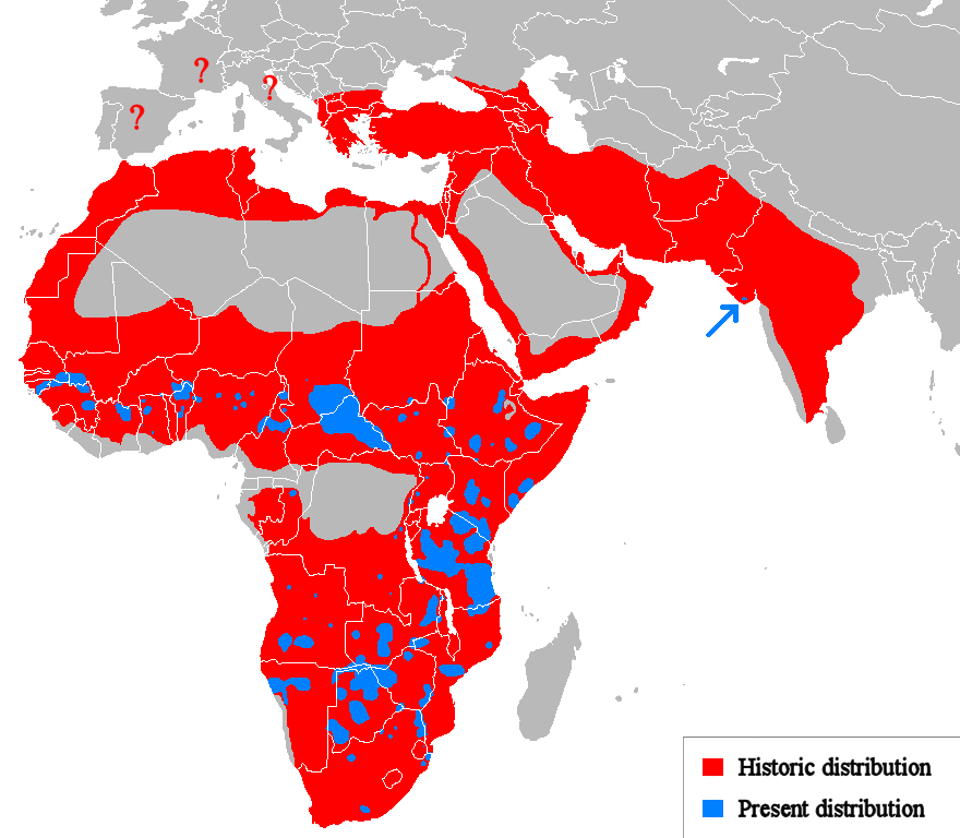
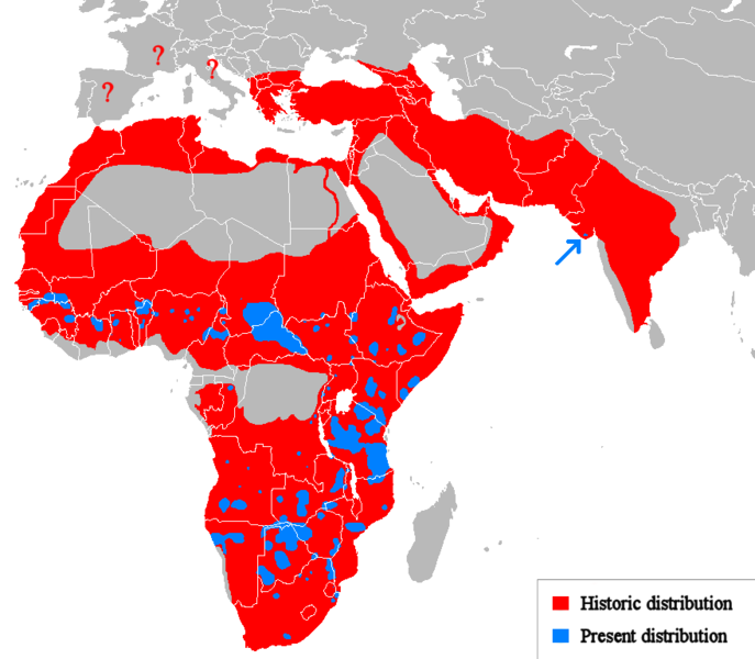
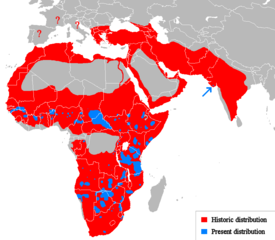
English: Geographical distribution of lions. Red (and blue) shows areas historically inhabited, blue shows areas currently inhabited.
Italiano: Areale storico (in rosso) ed attuale (in blu).
Русский: Ареал льва |
| ရက်စွဲ | (UTC) |
| ရင်းမြစ် |
Own work using:
|
| စာရေးသူ | Tommyknocker (talk) |
| အခြား ဗားရှင်းများ | Derivative works of this file: Lion distribution-ar.png |
လိုင်စင်သတ်မှတ်ခြင်း
| This work has been released into the public domain by its author, Tommyknocker at အင်္ဂလိပ် ဝီကီပီးဒီးယား. This applies worldwide. In some countries this may not be legally possible; if so: Tommyknocker grants anyone the right to use this work for any purpose, without any conditions, unless such conditions are required by law. |
မူရင်းတင်ထားသောမှတ်တမ်း
Transferred from en.wikipedia to Commons by Egmontaz using CommonsHelper.
ဖော်ပြချက် မူရင်းစာမျက်နှာမှာ here ဖြစ်သည်။ အောက်ပါအသုံးပြုသူ အမည်များအားလုံးသည် en.wikipedia ကို ရည်ညွှန်းသည်။
- 2009-08-26 11:21 Tommyknocker 882×770× (42518 bytes) '
- 2009-08-24 21:02 Tommyknocker 882×770× (42434 bytes) {{Information |Description = |Source = I (~~~) created this work entirely by myself. |Date = ~~~~~ |Author = ~~~ |other_versions = }}
ဖိုင်မှတ်တမ်း
ဖိုင်ကို ယင်းနေ့စွဲ အတိုင်း မြင်နိုင်ရန် နေ့စွဲ/အချိန် တစ်ခုခုပေါ်တွင် ကလစ်နှိပ်ပါ။
| နေ့စွဲ/အချိန် | နမူနာပုံငယ် | မှတ်တမ်း ဒိုင်မန်းရှင်းများ | အသုံးပြုသူ | မှတ်ချက် | |
|---|---|---|---|---|---|
| ကာလပေါ် | ၁၁:၅၁၊ ၂၂ မတ် ၂၀၁၈ | | ၈၈၀ × ၇၆၈ (၅၁ KB) | Maphobbyist | Check |
| ၁၁:၂၃၊ ၂၂ မတ် ၂၀၁၈ |  | ၈၈၀ × ၇၆၈ (၅၁ KB) | Maphobbyist | South Sudan border | |
| ၀၁:၀၇၊ ၁၅ မေ ၂၀၁၂ |  | ၈၈၀ × ၇၆၈ (၃၃ KB) | Ras67 | cropped, optimized | |
| ၁၄:၀၆၊ ၁၉ ဧပြီ ၂၀၁၀ |  | ၈၈၂ × ၇၇၀ (၅၉ KB) | MPF | Change red/green to red/blue to avoid problems for viewers with red-green colourblindness | |
| ၂၀:၀၀၊ ၁၁ ဇန်နဝါရီ ၂၀၁၀ |  | ၈၈၂ × ၇၇၀ (၄၄ KB) | Tommyknocker | Distribution in Southern Europe during historical times controversial, therefore now represented with question marks. | |
| ၁၇:၀၁၊ ၂ နိုဝင်ဘာ ၂၀၀၉ |  | ၈၈၂ × ၇၇၀ (၄၂ KB) | File Upload Bot (Magnus Manske) | {{BotMoveToCommons|en.wikipedia|year={{subst:CURRENTYEAR}}|month={{subst:CURRENTMONTHNAME}}|day={{subst:CURRENTDAY}}}} {{Information |Description={{en|''no original description''}} |Source=Transferred from [http://en.wikipedia.org en.wikipedia]; transfer |
ဖိုင်သုံးစွဲမှု
အောက်ပါ စာမျက်နှာ သည် ဤဖိုင်ကို အသုံးပြုထားသည်:
ဂလိုဘယ် ဖိုင်သုံးစွဲမှု
အောက်ပါ အခြားဝီကီများတွင် ဤဖိုင်ကို အသုံးပြုထားသည်-
- ab.wikipedia.org တွင် အသုံးပြုမှု
- af.wikipedia.org တွင် အသုံးပြုမှု
- alt.wikipedia.org တွင် အသုံးပြုမှု
- am.wikipedia.org တွင် အသုံးပြုမှု
- ary.wikipedia.org တွင် အသုံးပြုမှု
- arz.wikipedia.org တွင် အသုံးပြုမှု
- ast.wikipedia.org တွင် အသုံးပြုမှု
- as.wikipedia.org တွင် အသုံးပြုမှု
- azb.wikipedia.org တွင် အသုံးပြုမှု
- ban.wikipedia.org တွင် အသုံးပြုမှု
- ba.wikipedia.org တွင် အသုံးပြုမှု
- bcl.wikipedia.org တွင် အသုံးပြုမှု
- be.wikipedia.org တွင် အသုံးပြုမှု
- bg.wikipedia.org တွင် အသုံးပြုမှု
- bh.wikipedia.org တွင် အသုံးပြုမှု
- bn.wikipedia.org တွင် အသုံးပြုမှု
- bs.wikipedia.org တွင် အသုံးပြုမှု
- ca.wikipedia.org တွင် အသုံးပြုမှု
- ca.wikiquote.org တွင် အသုံးပြုမှု
- ceb.wikipedia.org တွင် အသုံးပြုမှု
- ce.wikipedia.org တွင် အသုံးပြုမှု
- ckb.wikipedia.org တွင် အသုံးပြုမှု
- cs.wikipedia.org တွင် အသုံးပြုမှု
- de.wikipedia.org တွင် အသုံးပြုမှု
- de.wikibooks.org တွင် အသုံးပြုမှု
- diq.wikipedia.org တွင် အသုံးပြုမှု
- el.wikipedia.org တွင် အသုံးပြုမှု
- en.wikipedia.org တွင် အသုံးပြုမှု
- eo.wikipedia.org တွင် အသုံးပြုမှု
- eo.wiktionary.org တွင် အသုံးပြုမှု
- es.wikipedia.org တွင် အသုံးပြုမှု
- es.wikibooks.org တွင် အသုံးပြုမှု
- et.wikipedia.org တွင် အသုံးပြုမှု
- eu.wikipedia.org တွင် အသုံးပြုမှု
ဤဖိုင်ကို အခြားနေရာများတွင် အသုံးပြုထားမှုများအား ကြည့်ရှုရန်။