ဖိုင်:Map iran biotopes simplified-fr.png

ဤနမူနာ၏ အရွယ်အစား - ၆၅၇ × ၆၀၀ ပစ်ဇယ်။ အခြား ပုံရိပ်ပြတ်သားမှု: ၂၆၃ × ၂၄၀ ပစ်ဇယ် | ၅၂၆ × ၄၈၀ ပစ်ဇယ် | ၈၄၁ × ၇၆၈ ပစ်ဇယ် | ၁၁၂၅ × ၁၀၂၇ ပစ်ဇယ်။
မူရင်းဖိုင် (၁၁၂၅ × ၁၀၂၇ pixels, ဖိုင်အရွယ်အစား - ၂၉၁ KB, MIME အမျိုးအစား image/png)
| ဤဖိုင်သည် Wikimedia Commons မှဖြစ်ပြီး အခြားပရောဂျက်များတွင် သုံးကောင်းသုံးလိမ့်မည်။ ယင်း၏ ဖိုင်အကြောင်းစာမျက်နှာ တွင် ဖော်ပြထားချက်ကို အောက်တွင် ပြထားသည်။ Commons သည် မူပိုင်ခွင့်လွတ်လပ်သော မီဒီယာဖိုင်များ သိုလှောင်ထားရာ နေရာ ဖြစ်သည်။ သင်လည်း ပါဝင်ကူညီနိုင်ပါသည်။ |

|
This map image could be re-created using vector graphics as an SVG file. This has several advantages; see Commons:Media for cleanup for more information. If an SVG form of this image is available, please upload it and afterwards replace this template with
{{vector version available|new image name}}.
It is recommended to name the SVG file “Map iran biotopes simplified-fr.svg”—then the template Vector version available (or Vva) does not need the new image name parameter. |
| ဖော်ပြချက် |
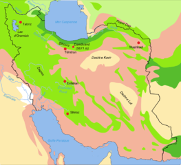
Simplified/improved version of Image:Iran biotopes.png, in french Forest steppe/Steppe arborée
Forests and woodlands/Zones arborées
Semi-desert/zones semi désertiques
Desert lowlands/plaines désertiques
Steppe
Salted alluvial marshes/Marais saumâtres alluviaux |
| ရက်စွဲ | |
| ရင်းမြစ် | Image:Iran biotopes.png |
| စာရေးသူ | Fabienkhan |
| ခွင့်ပြုချက် (ဤဖိုင်ကို ပြန်လည်အသုံးပြုခြင်း) |
ကျွန်ုပ်၊ ဤလုပ်ဆောင်ချက်၏ မူပိုင်ခွင့်ပိုင်ရှင်အနေဖြင့် ဤနေရာမှ အောက်ပါလိုင်စင်အောက်တွင် ထုတ်လွှင့်ပါသည်: ဤဖိုင်သည် Creative Commons Attribution-Share Alike 2.5 Generic, 2.0 Generic and 1.0 Generic လိုင်စင်အောက်တွင် လိုင်စင်သတ်မှတ်ထားပါသည်။
|
| အခြား ဗားရှင်းများ | all the biotopes of Iran : Image:Iran biotopes.png (without rivers and topographic names) |
ဖိုင်မှတ်တမ်း
ဖိုင်ကို ယင်းနေ့စွဲ အတိုင်း မြင်နိုင်ရန် နေ့စွဲ/အချိန် တစ်ခုခုပေါ်တွင် ကလစ်နှိပ်ပါ။
| နေ့စွဲ/အချိန် | နမူနာပုံငယ် | မှတ်တမ်း ဒိုင်မန်းရှင်းများ | အသုံးပြုသူ | မှတ်ချက် | |
|---|---|---|---|---|---|
| ကာလပေါ် | ၁၉:၄၉၊ ၁၃ ဇန်နဝါရီ ၂၀၁၃ | | ၁၁၂၅ × ၁၀၂၇ (၂၉၁ KB) | Locoluis | Reupload because of lost color profile. |
| ၁၉:၃၆၊ ၁၃ ဇန်နဝါရီ ၂၀၁၃ |  | ၁၁၂၅ × ၁၀၂၇ (၂၈၅ KB) | Locoluis | Changed the colors of the steppe and forest-steppe zones, as they looked too close to each other, and thus difficult to tell apart. | |
| ၁၈:၄၀၊ ၁၂ ဒီဇင်ဘာ ၂၀၁၀ |  | ၁၁၂၅ × ၁၀၂၇ (၃၂၇ KB) | P. S. Burton | removed frame | |
| ၁၁:၃၂၊ ၂၂ ဒီဇင်ဘာ ၂၀၀၆ |  | ၁၁၄၅ × ၁၀၄၁ (၂၉၀ KB) | Fabienkhan | improved version | |
| ၁၁:၃၀၊ ၂၂ ဒီဇင်ဘာ ၂၀၀၆ |  | ၁၅၇၁ × ၁၄၂၄ (၃၀၂ KB) | Fabienkhan | {{Information |Description=Simplified/improved version of Image:Iran biotopes.png, in french {{legend|#aeff2f|Forest steppe/Steppe arborée}} {{legend|#32cd32|Forests and woodlands/Zones arborées}} {{legend|#ffe159|Semi-desert/zones semi désertique |
ဖိုင်သုံးစွဲမှု
အောက်ပါ စာမျက်နှာ သည် ဤဖိုင်ကို အသုံးပြုထားသည်:
ဂလိုဘယ် ဖိုင်သုံးစွဲမှု
အောက်ပါ အခြားဝီကီများတွင် ဤဖိုင်ကို အသုံးပြုထားသည်-
- arz.wikipedia.org တွင် အသုံးပြုမှု
- ast.wikipedia.org တွင် အသုံးပြုမှု
- bn.wikipedia.org တွင် အသုံးပြုမှု
- bs.wikipedia.org တွင် အသုံးပြုမှု
- ca.wikipedia.org တွင် အသုံးပြုမှု
- ceb.wikipedia.org တွင် အသုံးပြုမှု
- cs.wikipedia.org တွင် အသုံးပြုမှု
- da.wikipedia.org တွင် အသုံးပြုမှု
- diq.wikipedia.org တွင် အသုံးပြုမှု
- el.wikipedia.org တွင် အသုံးပြုမှု
- en.wikipedia.org တွင် အသုံးပြုမှု
- es.wikipedia.org တွင် အသုံးပြုမှု
- fa.wikipedia.org တွင် အသုံးပြုမှု
- fi.wikipedia.org တွင် အသုံးပြုမှု
- fr.wikipedia.org တွင် အသုံးပြုမှု
- gl.wikipedia.org တွင် အသုံးပြုမှု
- hi.wikipedia.org တွင် အသုံးပြုမှု
- hr.wikipedia.org တွင် အသုံးပြုမှု
- hu.wikipedia.org တွင် အသုံးပြုမှု
- hy.wikipedia.org တွင် အသုံးပြုမှု
- it.wikipedia.org တွင် အသုံးပြုမှု
- ja.wikipedia.org တွင် အသုံးပြုမှု
- kn.wikipedia.org တွင် အသုံးပြုမှု
- ml.wikipedia.org တွင် အသုံးပြုမှု
- mt.wikipedia.org တွင် အသုံးပြုမှု
- nap.wikipedia.org တွင် အသုံးပြုမှု
- nl.wikipedia.org တွင် အသုံးပြုမှု
ဤဖိုင်ကို အခြားနေရာများတွင် အသုံးပြုထားမှုများအား ကြည့်ရှုရန်။