ဖိုင်:Yugoslavia 1956-1990.svg

Size of this PNG preview of this SVG file: ၄၅၀ × ၄၅၆ ပစ်ဇယ်. အခြား ပုံရိပ်ပြတ်သားမှု: ၂၃၇ × ၂၄၀ ပစ်ဇယ် | ၄၇၄ × ၄၈၀ ပစ်ဇယ် | ၇၅၈ × ၇၆၈ ပစ်ဇယ် | ၁၀၁၁ × ၁၀၂၄ ပစ်ဇယ် | ၂၀၂၁ × ၂၀၄၈ ပစ်ဇယ်။
မူရင်းဖိုင် (SVG ဖိုင်, ၄၅၀ × ၄၅၆ pixels ကို အကြံပြုသည်, ဖိုင်အရွယ်အစား - ၄၇၅ KB)
| ဤဖိုင်သည် Wikimedia Commons မှဖြစ်ပြီး အခြားပရောဂျက်များတွင် သုံးကောင်းသုံးလိမ့်မည်။ ယင်း၏ ဖိုင်အကြောင်းစာမျက်နှာ တွင် ဖော်ပြထားချက်ကို အောက်တွင် ပြထားသည်။ Commons သည် မူပိုင်ခွင့်လွတ်လပ်သော မီဒီယာဖိုင်များ သိုလှောင်ထားရာ နေရာ ဖြစ်သည်။ သင်လည်း ပါဝင်ကူညီနိုင်ပါသည်။ |
အကျဉ်းချုပ်


.svg)
.svg)
.svg)
.svg)
.svg)


.svg)
.svg)
.svg)


.png)
.png)


.svg)


.svg)

.svg)


.svg)
.svg)
.svg)
.svg)


.svg)
.png)


.svg)


.svg)
.svg)


.svg)


.svg)


.svg)
.svg)
.svg)
.svg)
.svg)
.svg)
.svg)
_cropped.svg)
.svg)
.svg)
.svg)
.svg)
.svg)
.svg)
.svg)
.svg)
.svg)
.svg)
.svg)
.svg)
.svg)
.svg)
.svg)
.svg)
.svg)
.svg)
.svg)
.svg)
.svg)
.svg)
.svg)
.svg)
.svg)
.svg)
.svg)
.svg)
.svg)
.svg)
.svg)
.svg)
.svg)
.svg)
.svg)
.svg)
.svg)
.svg)
.svg)
.svg)
.svg)
.svg)
.svg)
.svg)
.svg)
| This is a retouched picture, which means that it has been digitally altered from its original version. The original can be viewed here: Blank map of Europe 1956-1990.svg:
|
လိုင်စင်သတ်မှတ်ခြင်း
ကျွန်ုပ်၊ ဤလုပ်ဆောင်ချက်၏ မူပိုင်ခွင့်ပိုင်ရှင်အနေဖြင့် ဤနေရာမှ အောက်ပါလိုင်စင်အောက်တွင် ထုတ်လွှင့်ပါသည်:
ဤဖိုင်ကို Creative Commons Attribution-Share Alike 3.0 Unported လိုင်စင်ဖြင့် သတ်မှတ်ထားသည်။
- သင်သည် လွတ်လပ်စွာ:
- မျှဝေရန် – ဖန်တီးမှုကို ကူးယူရန်၊ ဖြန့်ဖြူးရန်နှင့် ထုတ်လွှင့်ရန်
- ပြန်ရောနှောရန် – ဖန်တီးမှုကို ပြင်ဆင်ညှိနှိုင်းရန်
- အောက်ပါ အခြေအနေများတွင်:
- မှတ်ယူနိုင်ခြင်း – ပြောင်းလဲမှုများ ပြုလုပ်ခဲ့ပါက ဖန်တီးသူ သို့မဟုတ် လိုင်စင်ရှိသူမှ သတ်မှတ်သော အမျိုးအစားကို လိုက်နာရမည် (ဆိုလိုသည်မှာ သင့်အား သို့မဟုတ် သင့်ဖန်တီးမှုတွင် အသုံးပြုခြင်းအား ထောက်ခံချက်ပေးသည်ဟု မဆိုလိုပါ)။
- ထပ်တူမျှဝေ – ဤဖန်တီးမှုအား ပြင်ဆင်ခြင်း၊ ပြောင်းလဲခြင်း သို့မဟုတ် ထပ်ဆင့် ဖန်တီးခြင်း ပြုလုပ်ပါက ရရှိလာသော ဖန်တီးမှုကို ဤဖန်တီးမှုနှင့် သို့မဟုတ် ဆင်တူသော လိုင်စင်ဖြင့်သာ ဖြန့်ချိသင့်သည်။
မူရင်းတင်ထားသောမှတ်တမ်း
This image is a derivative work of the following images:
- File:Blank_map_of_Europe_1956-1990.svg licensed with Cc-by-sa-3.0
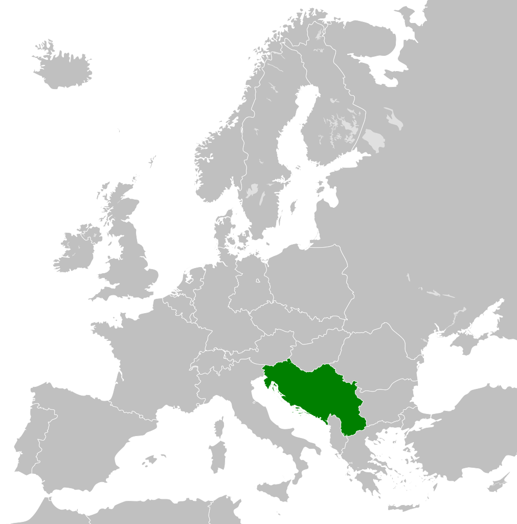
- 2011-10-30T04:43:42Z Alphathon 450x456 (485146 Bytes) == {{int:filedesc}} == {{Information |Description={{en|Blank map of Europe showing national borders as they stood from 1956-1990.}} |Source=*[[:File:Blank_map_of_Europe.svg|]] |Date=2011-10-30 04:42 (UTC) |Author=*[[:File:Bla
| Annotations | This image is annotated: View the annotations at Commons |
ဖိုင်မှတ်တမ်း
ဖိုင်ကို ယင်းနေ့စွဲ အတိုင်း မြင်နိုင်ရန် နေ့စွဲ/အချိန် တစ်ခုခုပေါ်တွင် ကလစ်နှိပ်ပါ။
| နေ့စွဲ/အချိန် | နမူနာပုံငယ် | မှတ်တမ်း ဒိုင်မန်းရှင်းများ | အသုံးပြုသူ | မှတ်ချက် | |
|---|---|---|---|---|---|
| ကာလပေါ် | ၀၁:၀၀၊ ၂၆ နိုဝင်ဘာ ၂၀၁၁ | | ၄၅၀ × ၄၅၆ (၄၇၅ KB) | StalwartUK | == {{int:filedesc}} == {{Information |Description={{en|Map of Socialist Federal Republic of Yugoslavia as it was from 1945-1992. Surrounding countries accurate from 1956-1990.}} |Source=*[[:File:Blank_map_o |
ဖိုင်သုံးစွဲမှု
အောက်ပါ စာမျက်နှာ သည် ဤဖိုင်ကို အသုံးပြုထားသည်:
ဂလိုဘယ် ဖိုင်သုံးစွဲမှု
အောက်ပါ အခြားဝီကီများတွင် ဤဖိုင်ကို အသုံးပြုထားသည်-
- ar.wikipedia.org တွင် အသုံးပြုမှု
- arz.wikipedia.org တွင် အသုံးပြုမှု
- ast.wikipedia.org တွင် အသုံးပြုမှု
- ast.wiktionary.org တွင် အသုံးပြုမှု
- azb.wikipedia.org တွင် အသုံးပြုမှု
- az.wikipedia.org တွင် အသုံးပြုမှု
- az.wiktionary.org တွင် အသုံးပြုမှု
- be-tarask.wikipedia.org တွင် အသုံးပြုမှု
- be.wikipedia.org တွင် အသုံးပြုမှု
- bg.wikipedia.org တွင် အသုံးပြုမှု
- bs.wikipedia.org တွင် အသုံးပြုမှု
- ca.wikipedia.org တွင် အသုံးပြုမှု
- ce.wikipedia.org တွင် အသုံးပြုမှု
- cs.wikipedia.org တွင် အသုံးပြုမှု
- da.wikipedia.org တွင် အသုံးပြုမှု
- de.wikipedia.org တွင် အသုံးပြုမှု
- en.wikipedia.org တွင် အသုံးပြုမှု
- Socialist Federal Republic of Yugoslavia
- User:Mr Hall of England/sandbox
- Telephone numbers in Yugoslavia
- User:Falcaorib
- Soviet involvement in regime change
- User:XP6287/sandbox
- Guyana–Yugoslavia relations
- Cyprus–Yugoslavia relations
- Afghanistan–Yugoslavia relations
- Pakistan–Yugoslavia relations
- Canada–Yugoslavia relations
- Malta–Yugoslavia relations
- Germany–Yugoslavia relations
- Nicaragua–Yugoslavia relations
- Brazil–Yugoslavia relations
- Cambodia–Yugoslavia relations
- List of companies of the Socialist Federal Republic of Yugoslavia
- en.wiktionary.org တွင် အသုံးပြုမှု
- es.wikipedia.org တွင် အသုံးပြုမှု
- es.wiktionary.org တွင် အသုံးပြုမှု
- eu.wikipedia.org တွင် အသုံးပြုမှု
- fa.wikipedia.org တွင် အသုံးပြုမှု
- fi.wikipedia.org တွင် အသုံးပြုမှု
- fo.wikipedia.org တွင် အသုံးပြုမှု
- frr.wikipedia.org တွင် အသုံးပြုမှု
- fr.wikipedia.org တွင် အသုံးပြုမှု
ဤဖိုင်ကို အခြားနေရာများတွင် အသုံးပြုထားမှုများအား ကြည့်ရှုရန်။