ဖိုင်:Bosnia and Hercegovina map.png

မူရင်းဖိုင် (၂၃၀၂ × ၂၉၀၁ pixels, ဖိုင်အရွယ်အစား - ၁.၅ MB, MIME အမျိုးအစား image/png)
| ဤဖိုင်သည် Wikimedia Commons မှဖြစ်ပြီး အခြားပရောဂျက်များတွင် သုံးကောင်းသုံးလိမ့်မည်။ ယင်း၏ ဖိုင်အကြောင်းစာမျက်နှာ တွင် ဖော်ပြထားချက်ကို အောက်တွင် ပြထားသည်။ Commons သည် မူပိုင်ခွင့်လွတ်လပ်သော မီဒီယာဖိုင်များ သိုလှောင်ထားရာ နေရာ ဖြစ်သည်။ သင်လည်း ပါဝင်ကူညီနိုင်ပါသည်။ |
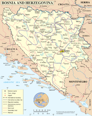
UN Bosnia and Hercegovina map
| ဖော်ပြချက် | Map of Bosnia and Hercegovina | |||
| ရက်စွဲ | ||||
| ရင်းမြစ် | The Cartographic Section of the United Nations (CSUN) | |||
| စာရေးသူ | Cartographer of the United Nations | |||
| ခွင့်ပြုချက် (ဤဖိုင်ကို ပြန်လည်အသုံးပြုခြင်း) |
|

ဖိုင်မှတ်တမ်း
ဖိုင်ကို ယင်းနေ့စွဲ အတိုင်း မြင်နိုင်ရန် နေ့စွဲ/အချိန် တစ်ခုခုပေါ်တွင် ကလစ်နှိပ်ပါ။
| နေ့စွဲ/အချိန် | နမူနာပုံငယ် | မှတ်တမ်း ဒိုင်မန်းရှင်းများ | အသုံးပြုသူ | မှတ်ချက် | |
|---|---|---|---|---|---|
| ကာလပေါ် | ၁၆:၄၈၊ ၁၁ မေ ၂၀၁၀ | | ၂၃၀၂ × ၂၉၀၁ (၁.၅ MB) | Ras67 | cropped |
| ၀၁:၂၆၊ ၂၃ အောက်တိုဘာ ၂၀၀၇ |  | ၂၃၄၈ × ၂၉၄၈ (၂.၀၅ MB) | Jeroen | Higher reolution | |
| ၂၃:၀၃၊ ၉ မတ် ၂၀၀၇ |  | ၁၈၈၀ × ၂၃၄၉ (၁.၂၈ MB) | Minestrone | UN Bosnia and Hercegovina map {{Information |Description=Map of Bosnia and Hercegovina |Source=The Cartographic Section of the United Nations (CSUN) |Date=2007-03-10 |Author=Cartographer of the United Nations |Permission={{Template:UN map}} and the |
ဖိုင်သုံးစွဲမှု
အောက်ပါ စာမျက်နှာ သည် ဤဖိုင်ကို အသုံးပြုထားသည်:
ဂလိုဘယ် ဖိုင်သုံးစွဲမှု
အောက်ပါ အခြားဝီကီများတွင် ဤဖိုင်ကို အသုံးပြုထားသည်-
- ace.wikipedia.org တွင် အသုံးပြုမှု
- als.wikipedia.org တွင် အသုံးပြုမှု
- an.wikipedia.org တွင် အသုံးပြုမှု
- bcl.wikipedia.org တွင် အသုံးပြုမှု
- ckb.wikipedia.org တွင် အသုံးပြုမှု
- cu.wikipedia.org တွင် အသုံးပြုမှု
- de.wikipedia.org တွင် အသုံးပြုမှု
- en.wikipedia.org တွင် အသုံးပြုမှု
- fa.wikipedia.org တွင် အသုံးပြုမှု
- frr.wikipedia.org တွင် အသုံးပြုမှု
- gd.wikipedia.org တွင် အသုံးပြုမှု
- hy.wikipedia.org တွင် အသုံးပြုမှု
- id.wikipedia.org တွင် အသုံးပြုမှု
- incubator.wikimedia.org တွင် အသုံးပြုမှု
- ja.wikipedia.org တွင် အသုံးပြုမှု
- jv.wikipedia.org တွင် အသုံးပြုမှု
- kg.wikipedia.org တွင် အသုံးပြုမှု
- ki.wikipedia.org တွင် အသုံးပြုမှု
- ln.wikipedia.org တွင် အသုံးပြုမှု
- mzn.wikipedia.org တွင် အသုံးပြုမှု
- nl.wikipedia.org တွင် အသုံးပြုမှု
- nov.wikipedia.org တွင် အသုံးပြုမှု
- pl.wiktionary.org တွင် အသုံးပြုမှု
- ru.wikipedia.org တွင် အသုံးပြုမှု
- sl.wikipedia.org တွင် အသုံးပြုမှု
- sq.wikinews.org တွင် အသုံးပြုမှု
- uk.wikipedia.org တွင် အသုံးပြုမှု
- uk.wiktionary.org တွင် အသုံးပြုမှု
- wo.wikipedia.org တွင် အသုံးပြုမှု