ဖိုင်:Irrawaddyrivermap.jpg
ဤနမူနာ၏ အရွယ်အစား - ၄၂၁ × ၅၉၉ ပစ်ဇယ်။ အခြား ပုံရိပ်ပြတ်သားမှု: ၁၆၈ × ၂၄၀ ပစ်ဇယ် | ၃၃၇ × ၄၈၀ ပစ်ဇယ် | ၈၆၂ × ၁၂၂၇ ပစ်ဇယ်။
မူရင်းဖိုင် (၈၆၂ × ၁၂၂၇ pixels, ဖိုင်အရွယ်အစား - ၂၀၈ KB, MIME အမျိုးအစား image/jpeg)
| ဤဖိုင်သည် Wikimedia Commons မှဖြစ်ပြီး အခြားပရောဂျက်များတွင် သုံးကောင်းသုံးလိမ့်မည်။ ယင်း၏ ဖိုင်အကြောင်းစာမျက်နှာ တွင် ဖော်ပြထားချက်ကို အောက်တွင် ပြထားသည်။ Commons သည် မူပိုင်ခွင့်လွတ်လပ်သော မီဒီယာဖိုင်များ သိုလှောင်ထားရာ နေရာ ဖြစ်သည်။ သင်လည်း ပါဝင်ကူညီနိုင်ပါသည်။ |
အကျဉ်းချုပ်
| ဖော်ပြချက် |
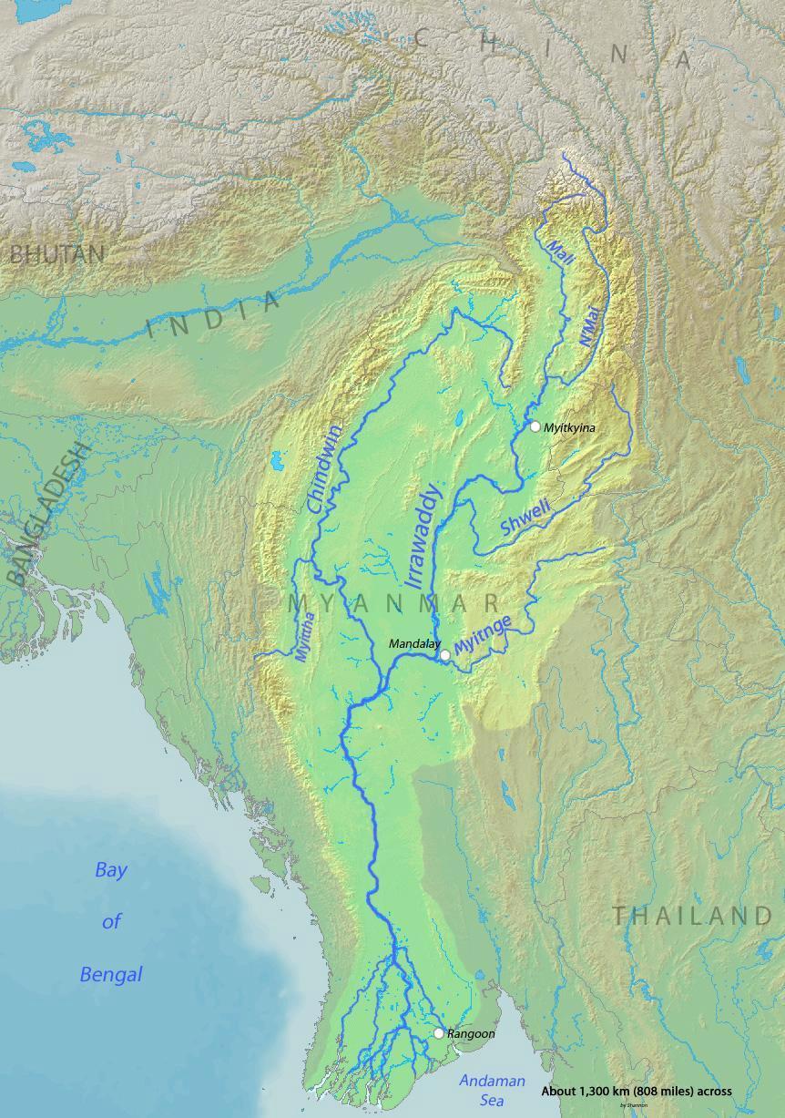
English: Map of the Irrawaddy River, which drains parts of Myanmar (Burma), Thailand and India into the Andaman Sea Français : Carte de l'Irrawaddy. Myitnge |
| ရက်စွဲ | |
| ရင်းမြစ် | Background and river course data from http://www2.demis.nl/mapserver/mapper.asp |
| စာရေးသူ | Shannon |
လိုင်စင်သတ်မှတ်ခြင်း
ကျွန်ုပ်၊ ဤလုပ်ဆောင်ချက်၏ မူပိုင်ခွင့်ပိုင်ရှင်အနေဖြင့် ဤနေရာမှ အောက်ပါလိုင်စင်များအောက်တွင် ထုတ်လွှင့်ပါသည်:

|
ဤစာတမ်းကို GNU Free Documentation License, ဗားရှင်း ၁.၂ သို့မဟုတ် Free Software Foundation မှ ဖြန့်ချီထားသော မည်သည့်ယခင်ဗားရှင်းတစ်ခုခုအောက်တွင် Invariant Sections, Front-Cover Texts နှင့် Back-Cover Texts များမပါဝင်ဘဲ ကူးယူခြင်း၊ ဖြန့်ချီခြင်း နှင့်/သို့မဟုတ် ပြင်ဆင်ပြောင်းလဲနိုင်ရန် ခွင့်ပြုသည်။ လိုင်စင်မူပွားကို GNU Free Documentation License ခေါင်းစဉ်အောက်တွင် ထည့်သွင်းထားသည်။ |
This file is licensed under the Creative Commons Attribution-Share Alike 4.0 International, 3.0 Unported, 2.5 Generic, 2.0 Generic and 1.0 Generic license.
- သင်သည် လွတ်လပ်စွာ:
- မျှဝေရန် – ဖန်တီးမှုကို ကူးယူရန်၊ ဖြန့်ဖြူးရန်နှင့် ထုတ်လွှင့်ရန်
- ပြန်ရောနှောရန် – ဖန်တီးမှုကို ပြင်ဆင်ညှိနှိုင်းရန်
- အောက်ပါ အခြေအနေများတွင်:
- မှတ်ယူနိုင်ခြင်း – ပြောင်းလဲမှုများ ပြုလုပ်ခဲ့ပါက ဖန်တီးသူ သို့မဟုတ် လိုင်စင်ရှိသူမှ သတ်မှတ်သော အမျိုးအစားကို လိုက်နာရမည် (ဆိုလိုသည်မှာ သင့်အား သို့မဟုတ် သင့်ဖန်တီးမှုတွင် အသုံးပြုခြင်းအား ထောက်ခံချက်ပေးသည်ဟု မဆိုလိုပါ)။
- ထပ်တူမျှဝေ – ဤဖန်တီးမှုအား ပြင်ဆင်ခြင်း၊ ပြောင်းလဲခြင်း သို့မဟုတ် ထပ်ဆင့် ဖန်တီးခြင်း ပြုလုပ်ပါက ရရှိလာသော ဖန်တီးမှုကို ဤဖန်တီးမှုနှင့် သို့မဟုတ် ဆင်တူသော လိုင်စင်ဖြင့်သာ ဖြန့်ချိသင့်သည်။
သင်အလိုရှိရာ လိုင်စင်ကို ရွေးချယ်နိုင်ပါသည်။
ဖိုင်မှတ်တမ်း
ဖိုင်ကို ယင်းနေ့စွဲ အတိုင်း မြင်နိုင်ရန် နေ့စွဲ/အချိန် တစ်ခုခုပေါ်တွင် ကလစ်နှိပ်ပါ။
| နေ့စွဲ/အချိန် | နမူနာပုံငယ် | မှတ်တမ်း ဒိုင်မန်းရှင်းများ | အသုံးပြုသူ | မှတ်ချက် | |
|---|---|---|---|---|---|
| ကာလပေါ် | ၀၀:၃၂၊ ၁ ဒီဇင်ဘာ ၂၀၁၅ | | ၈၆၂ × ၁၂၂၇ (၂၀၈ KB) | Xufanc | Myittha River |
| ၀၈:၃၀၊ ၃၀ နိုဝင်ဘာ ၂၀၁၅ |  | ၈၆၂ × ၁၂၂၇ (၂၀၈ KB) | Xufanc | Reverted to version as of 08:22, 30 November 2015 (UTC) | |
| ၀၈:၂၈၊ ၃၀ နိုဝင်ဘာ ၂၀၁၅ |  | ၈၆၂ × ၁၂၂၇ (၂၀၈ KB) | Xufanc | Reverted to version as of 08:18, 30 November 2015 (UTC) | |
| ၀၈:၂၅၊ ၃၀ နိုဝင်ဘာ ၂၀၁၅ |  | ၈၆၂ × ၁၂၂၇ (၂၀၈ KB) | Xufanc | Reverted to version as of 08:18, 30 November 2015 (UTC) | |
| ၀၈:၂၂၊ ၃၀ နိုဝင်ဘာ ၂၀၁၅ |  | ၈၆၂ × ၁၂၂၇ (၂၀၈ KB) | Xufanc | added name of tributary | |
| ၀၈:၁၈၊ ၃၀ နိုဝင်ဘာ ၂၀၁၅ |  | ၈၆၂ × ၁၂၂၇ (၂၀၈ KB) | Xufanc | added name of tributary | |
| ၀၆:၃၈၊ ၂၄ စက်တင်ဘာ ၂၀၁၄ |  | ၈၆၂ × ၁၂၂၇ (၂၁၉ KB) | Xufanc | Corrected wrong label | |
| ၀၄:၀၆၊ ၃ မတ် ၂၀၁၀ |  | ၈၆၂ × ၁၂၂၇ (၆၅၃ KB) | Shannon1 | {{Information |Description={{en|1=Map of the Irrawaddy River, which drains parts of Myanmar (Burma), Thailand and India into the Andaman Sea}} |Source=Background and river course data from http://www2.demis.nl/mapserver/mapper.asp |Author=[[User:Shannonc |
ဖိုင်သုံးစွဲမှု
အောက်ပါ 6 စာမျက်နှာများ သည် ဤဖိုင်ကို အသုံးပြုထားသည်:
ဂလိုဘယ် ဖိုင်သုံးစွဲမှု
အောက်ပါ အခြားဝီကီများတွင် ဤဖိုင်ကို အသုံးပြုထားသည်-
- af.wikipedia.org တွင် အသုံးပြုမှု
- ar.wikipedia.org တွင် အသုံးပြုမှု
- ast.wikipedia.org တွင် အသုံးပြုမှု
- azb.wikipedia.org တွင် အသုံးပြုမှု
- be-tarask.wikipedia.org တွင် အသုံးပြုမှု
- bg.wikipedia.org တွင် အသုံးပြုမှု
- bh.wikipedia.org တွင် အသုံးပြုမှု
- blk.wikipedia.org တွင် အသုံးပြုမှု
- bn.wikipedia.org တွင် အသုံးပြုမှု
- br.wikipedia.org တွင် အသုံးပြုမှု
- ca.wikipedia.org တွင် အသုံးပြုမှု
- cs.wikipedia.org တွင် အသုံးပြုမှု
- cy.wikipedia.org တွင် အသုံးပြုမှု
- de.wikipedia.org တွင် အသုံးပြုမှု
- en.wikipedia.org တွင် အသုံးပြုမှု
- en.wikinews.org တွင် အသုံးပြုမှု
- es.wikipedia.org တွင် အသုံးပြုမှု
- eu.wikipedia.org တွင် အသုံးပြုမှု
- fa.wikipedia.org တွင် အသုံးပြုမှု
- fr.wikipedia.org တွင် အသုံးပြုမှု
- gl.wikipedia.org တွင် အသုံးပြုမှု
- hi.wikipedia.org တွင် အသုံးပြုမှု
- hr.wikipedia.org တွင် အသုံးပြုမှု
- hu.wikipedia.org တွင် အသုံးပြုမှု
- hy.wikipedia.org တွင် အသုံးပြုမှု
- id.wikipedia.org တွင် အသုံးပြုမှု
- ja.wikipedia.org တွင် အသုံးပြုမှု
- ka.wikipedia.org တွင် အသုံးပြုမှု
- ko.wikipedia.org တွင် အသုံးပြုမှု
- mk.wikipedia.org တွင် အသုံးပြုမှု
- ml.wikipedia.org တွင် အသုံးပြုမှု
- pl.wikipedia.org တွင် အသုံးပြုမှု
ဤဖိုင်ကို အခြားနေရာများတွင် အသုံးပြုထားမှုများအား ကြည့်ရှုရန်။