ဖိုင်:Kobli1.jpg
ဤနမူနာ၏ အရွယ်အစား - ၈၀၀ × ၅၃၁ ပစ်ဇယ်။ အခြား ပုံရိပ်ပြတ်သားမှု: ၃၂၀ × ၂၁၃ ပစ်ဇယ် | ၆၄၀ × ၄၂၅ ပစ်ဇယ် | ၁၀၂၄ × ၆၈၀ ပစ်ဇယ် | ၁၂၈၀ × ၈၅၀ ပစ်ဇယ် | ၁၆၂၆ × ၁၀၈၀ ပစ်ဇယ်။
မူရင်းဖိုင် (၁၆၂၆ × ၁၀၈၀ pixels, ဖိုင်အရွယ်အစား - ၇၀၂ KB, MIME အမျိုးအစား image/jpeg)
| ဤဖိုင်သည် Wikimedia Commons မှဖြစ်ပြီး အခြားပရောဂျက်များတွင် သုံးကောင်းသုံးလိမ့်မည်။ ယင်း၏ ဖိုင်အကြောင်းစာမျက်နှာ တွင် ဖော်ပြထားချက်ကို အောက်တွင် ပြထားသည်။ Commons သည် မူပိုင်ခွင့်လွတ်လပ်သော မီဒီယာဖိုင်များ သိုလှောင်ထားရာ နေရာ ဖြစ်သည်။ သင်လည်း ပါဝင်ကူညီနိုင်ပါသည်။ |
အကျဉ်းချုပ်
| Camera location | | View this and other nearby images on: OpenStreetMap |
|---|
| ဖော်ပြချက် |
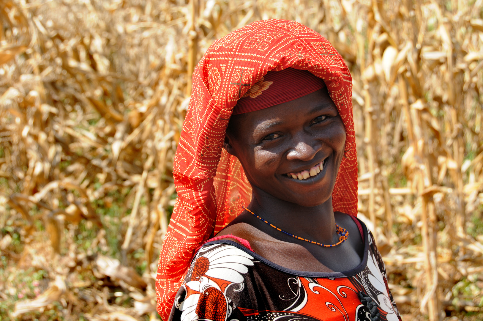
English: Kobli, Atakora, Benin |
|||
| ရက်စွဲ | ||||
| ရင်းမြစ် | Originally uploaded to Flickr | |||
| စာရေးသူ | Jacques Taberlet | |||
| ခွင့်ပြုချက် (ဤဖိုင်ကို ပြန်လည်အသုံးပြုခြင်း) |
|
|||
| အခြား ဗားရှင်းများ | ||||

လိုင်စင်သတ်မှတ်ခြင်း
ဤဖိုင်သည် Creative Commons Attribution 3.0 Unported လိုင်စင်အောက်တွင် လိုင်စင်သတ်မှတ်ထားပါသည်။
- သင်သည် လွတ်လပ်စွာ:
- မျှဝေရန် – ဖန်တီးမှုကို ကူးယူရန်၊ ဖြန့်ဖြူးရန်နှင့် ထုတ်လွှင့်ရန်
- ပြန်ရောနှောရန် – ဖန်တီးမှုကို ပြင်ဆင်ညှိနှိုင်းရန်
- အောက်ပါ အခြေအနေများတွင်:
- မှတ်ယူနိုင်ခြင်း – ပြောင်းလဲမှုများ ပြုလုပ်ခဲ့ပါက ဖန်တီးသူ သို့မဟုတ် လိုင်စင်ရှိသူမှ သတ်မှတ်သော အမျိုးအစားကို လိုက်နာရမည် (ဆိုလိုသည်မှာ သင့်အား သို့မဟုတ် သင့်ဖန်တီးမှုတွင် အသုံးပြုခြင်းအား ထောက်ခံချက်ပေးသည်ဟု မဆိုလိုပါ)။
ဖိုင်မှတ်တမ်း
ဖိုင်ကို ယင်းနေ့စွဲ အတိုင်း မြင်နိုင်ရန် နေ့စွဲ/အချိန် တစ်ခုခုပေါ်တွင် ကလစ်နှိပ်ပါ။
| နေ့စွဲ/အချိန် | နမူနာပုံငယ် | မှတ်တမ်း ဒိုင်မန်းရှင်းများ | အသုံးပြုသူ | မှတ်ချက် | |
|---|---|---|---|---|---|
| ကာလပေါ် | ၂၀:၄၀၊ ၈ ဖေဖော်ဝါရီ ၂၀၀၉ | | ၁၆၂၆ × ၁၀၈၀ (၇၀၂ KB) | Dr. Blofeld~commonswiki | {{Information |Description={{en|1=f}} |Source=f |Author=f |Date=f |Permission= |other_versions= }} <!--{{ImageUpload|full}}--> |
ဖိုင်သုံးစွဲမှု
အောက်ပါ စာမျက်နှာ သည် ဤဖိုင်ကို အသုံးပြုထားသည်:
ဂလိုဘယ် ဖိုင်သုံးစွဲမှု
အောက်ပါ အခြားဝီကီများတွင် ဤဖိုင်ကို အသုံးပြုထားသည်-
- ar.wikipedia.org တွင် အသုံးပြုမှု
- az.wikipedia.org တွင် အသုံးပြုမှု
- dsb.wikipedia.org တွင် အသုံးပြုမှု
- en.wikipedia.org တွင် အသုံးပြုမှု
- eo.wikipedia.org တွင် အသုံးပြုမှု
- Vikipedio:Bildo de la tago/2009 04
- Vikipedio:Bildo de la tago/2009 09
- Vikipedio:Bildo de la tago/2010 09
- Vikipedio:Bildo de la tago/2010 04
- Vikipedio:Bildo de la tago/2011 09
- Vikipedio:Bildo de la tago/2011 04
- Vikipedio:Bildo de la tago/2012 04
- Vikipedio:Bildo de la tago2/indekso/4
- Ŝablono:Bildo de la Tago2/185
- gl.wikipedia.org တွင် အသုံးပြုမှု
- hsb.wikipedia.org တွင် အသုံးပြုမှု
- Předłoha:Wobraz tydźenja/miniatura/slědowacyTydźeń
- Předłoha:Wobraz tydźenja/miniatura/slědowacyTydźeń/Dokumentacija
- Wikipedija:Wobrazy tydźenja/wobrazy přichodnych tydźenjow
- Předłoha:Wobraz tydźenja/linki
- Předłoha:Wobraz tydźenja/miniatura/slědowacyTydźeń/testy
- Předłoha:Wobraz tydźenja/linki/Dokumentacija
- Wikipedija:Wobrazy tydźenja/2015
- Wikipedija:Wobrazy tydźenja/2016
- Wikipedija:Wobrazy tydźenja/2017
- Wikipedija:Wobrazy tydźenja/2018
- Wikipedija:Wobrazy tydźenja/2024
- ja.wikipedia.org တွင် အသုံးပြုမှု
- ka.wikipedia.org တွင် အသုံးပြုမှု
- km.wikipedia.org တွင် အသုံးပြုမှု
- lv.wikipedia.org တွင် အသုံးပြုမှု
- ru.wikipedia.org တွင် အသုံးပြုမှု
- sa.wikipedia.org တွင် အသုံးပြုမှု
- sd.wikipedia.org တွင် အသုံးပြုမှု
- stq.wikipedia.org တွင် အသုံးပြုမှု
- sw.wikipedia.org တွင် အသုံးပြုမှု
- te.wikipedia.org တွင် အသုံးပြုမှု
- tly.wikipedia.org တွင် အသုံးပြုမှု
- tr.wikipedia.org တွင် အသုံးပြုမှု
- uk.wikipedia.org တွင် အသုံးပြုမှု
- uz.wikipedia.org တွင် အသုံးပြုမှု
- xmf.wikipedia.org တွင် အသုံးပြုမှု