ဖိုင်:Map of USA MD.svg

Size of this PNG preview of this SVG file: ၂၈၆ × ၁၈၆ ပစ်ဇယ်. အခြား ပုံရိပ်ပြတ်သားမှု: ၃၂၀ × ၂၀၈ ပစ်ဇယ် | ၆၄၀ × ၄၁၆ ပစ်ဇယ် | ၁၀၂၄ × ၆၆၆ ပစ်ဇယ် | ၁၂၈၀ × ၈၃၂ ပစ်ဇယ် | ၂၅၆၀ × ၁၆၆၅ ပစ်ဇယ်။
မူရင်းဖိုင် (SVG ဖိုင်, ၂၈၆ × ၁၈၆ pixels ကို အကြံပြုသည်, ဖိုင်အရွယ်အစား - ၁၆၇ KB)
| ဤဖိုင်သည် Wikimedia Commons မှဖြစ်ပြီး အခြားပရောဂျက်များတွင် သုံးကောင်းသုံးလိမ့်မည်။ ယင်း၏ ဖိုင်အကြောင်းစာမျက်နှာ တွင် ဖော်ပြထားချက်ကို အောက်တွင် ပြထားသည်။ Commons သည် မူပိုင်ခွင့်လွတ်လပ်သော မီဒီယာဖိုင်များ သိုလှောင်ထားရာ နေရာ ဖြစ်သည်။ သင်လည်း ပါဝင်ကူညီနိုင်ပါသည်။ |
Clickable version
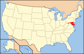
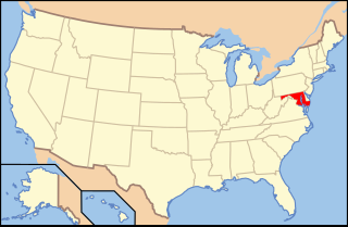
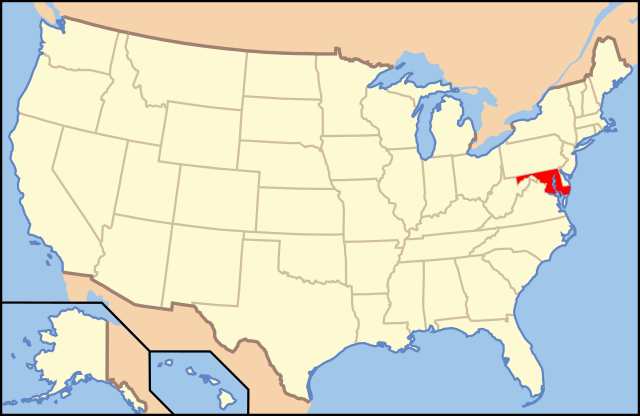
| ဖော်ပြချက် | Map of USA with Maryland highlighted | ||||||||
| ရက်စွဲ | see file history below. | ||||||||
| ရင်းမြစ် | ကိုယ်ပိုင်ဖန်တီးမှု (Original text: own work by uploader, Own work based on: Map of USA without state names.svg) | ||||||||
| စာရေးသူ |
This version: uploader Base versions this one is derived from: originally created by Wapcaplet |
||||||||
| ခွင့်ပြုချက် (ဤဖိုင်ကို ပြန်လည်အသုံးပြုခြင်း) |
ဤဖိုင်သည် Creative Commons Attribution 2.0 Generic လိုင်စင်အောက်တွင် လိုင်စင်သတ်မှတ်ထားပါသည်။
|
||||||||
| အခြား ဗားရှင်းများ | Map of USA with state names.svg | ||||||||
| SVG genesis | ဤ SVG ၏ ကုဒ်သည် ခိုင်လုံသည်။ This locator map was created with Inkscape. |

ဖိုင်မှတ်တမ်း
ဖိုင်ကို ယင်းနေ့စွဲ အတိုင်း မြင်နိုင်ရန် နေ့စွဲ/အချိန် တစ်ခုခုပေါ်တွင် ကလစ်နှိပ်ပါ။
| နေ့စွဲ/အချိန် | နမူနာပုံငယ် | မှတ်တမ်း ဒိုင်မန်းရှင်းများ | အသုံးပြုသူ | မှတ်ချက် | |
|---|---|---|---|---|---|
| ကာလပေါ် | ၁၃:၄၂၊ ၁ နိုဝင်ဘာ ၂၀၁၂ | | ၂၈၆ × ၁၈၆ (၁၆၇ KB) | Kmusser | remove VA portion of eastern shore |
| ၀၉:၀၆၊ ၂၆ ဧပြီ ၂၀၀၈ |  | ၂၈၆ × ၁၈၆ (၁၆၇ KB) | Rub1615~commonswiki | Reverted to version as of 07:11, 9 June 2006 | |
| ၁၅:၃၂၊ ၂၃ ဧပြီ ၂၀၀၈ |  | ၂၈၆ × ၁၈၆ (၁၈၃ KB) | Rfc1394 | Add an inset to the map enlarging the focus area to make it easier to see the designated state. | |
| ၀၇:၁၁၊ ၉ ဇွန် ၂၀၀၆ |  | ၂၈၆ × ၁၈၆ (၁၆၇ KB) | Huebi~commonswiki | {{Information| |Description=Map of USA with Maryland highlighted |other_versions=image:Map of USA with state names.svg }} Category:Maps of the United States Category:Maps of Maryland Category:SVG maps {{GFDL-en}}{{cc-by-2.0}}{{cc-by-sa- |
ဖိုင်သုံးစွဲမှု
ဤဖိုင်ကို အသုံးပြုထားသော စာမျက်နှာများမရှိပါ။
ဂလိုဘယ် ဖိုင်သုံးစွဲမှု
အောက်ပါ အခြားဝီကီများတွင် ဤဖိုင်ကို အသုံးပြုထားသည်-
- af.wikipedia.org တွင် အသုံးပြုမှု
- ang.wikipedia.org တွင် အသုံးပြုမှု
- an.wikipedia.org တွင် အသုံးပြုမှု
- arc.wikipedia.org တွင် အသုံးပြုမှု
- ar.wikipedia.org တွင် အသုံးပြုမှု
- arz.wikipedia.org တွင် အသုံးပြုမှု
- ay.wikipedia.org တွင် အသုံးပြုမှု
- az.wiktionary.org တွင် အသုံးပြုမှု
- bg.wikipedia.org တွင် အသုံးပြုမှု
- bi.wikipedia.org တွင် အသုံးပြုမှု
- bo.wikipedia.org တွင် အသုံးပြုမှု
- bpy.wikipedia.org တွင် အသုံးပြုမှု
- bxr.wikipedia.org တွင် အသုံးပြုမှု
- ca.wikipedia.org တွင် အသုံးပြုမှု
- ce.wikipedia.org တွင် အသုံးပြုမှု
- cs.wikipedia.org တွင် အသုံးပြုမှု
- da.wikipedia.org တွင် အသုံးပြုမှု
- Maryland
- Annapolis
- Baltimore
- Towson (Maryland)
- Worcester County (Maryland)
- Allegany County (Maryland)
- Anne Arundel County
- Denton (Maryland)
- Frederick (Maryland)
- Oakland (Maryland)
- Cumberland (Maryland)
- Sharpsburg (Maryland)
- Hagerstown (Maryland)
- La Plata (Maryland)
- Rockville (Maryland)
- Baltimore County
- Frederick County (Maryland)
ဤဖိုင်ကို အခြားနေရာများတွင် အသုံးပြုထားမှုများအား ကြည့်ရှုရန်။