တမ်းပလိတ်:Infobox earthquake/doc
| ဤစာမျက်နှာမှာ တမ်းပလိတ်:Infobox earthquake တမ်းပလိတ်အတွက် အသုံးပြုပုံ လက်စွဲ (documentation) ၏ စာမျက်နှာခွဲ (subpage) တစ်ခုဖြစ်သည်။ ဤစာမျက်နှာတွင် မူရင်း တမ်းပလိတ် page ၌ တစိတ်တပိုင်းအဖြစ် မပါဝင်သည့် အသုံးပြုပုံပြုနည်းနှင့် သက်ဆိုင်သည့် သတင်းအချက်များ၊ ကဏ္ဍများ နှင့် အခြားအချက်အလက်များ ပါဝင်သည်။ |
အသုံးပြုပုံ
ပြင်ဆင်ရန်{{Infobox earthquake
| name =
| image = <!-- file name only -->
| alt =
| caption =
| map = <!-- file name only -->
| map_alt =
| map_caption =
| map2 = <!-- manual map or use {{Location map}} -->
| date = <!-- {{Start date|YYYY|MM|DD}} -->
| time =
| duration =
| magnitude = <!-- NNN [[Moment magnitude scale|M<sub>w</sub>]] -->
| depth = <!-- {{convert|NNN|km|mi|0|abbr=on}} -->
| location = <!-- {{coord|XXXXX|region:XX_type:event|display=inline,title}} -->
| type =
| affected =
| damages = <!-- cost/extent of property damage -->
| intensity =
| pga = <!-- NN''[[Peak ground acceleration|g]]'' -->
| tsunami =
| landslide =
| foreshocks =
| aftershocks =
| casualties =
}}
နမူနာ
ပြင်ဆင်ရန် Piles of rubble, one week after the shock | |
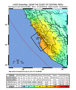
 ပီရူးကမ်းရိုးတန်းမြေပုံ၊ ငလျင်ဖြစ်ပွားရာနေရာနှင့် ပြင်းအားကို ဖော်ပြထားသည်။ ကြယ်အမှတ်အသားမှာ ငလျင်ဗဟိုဖြစ်သည်။ | |
| UTC အချိန် | ?? |
|---|---|
| ရက်စွဲ * | ဩဂုတ် ၁၅၊ ၂၀၀၇ |
| မူလ အချိန် * | ၂၃:၄၀:၅၇ UTC |
| အတိုင်းအတာ | ၈.၀ Mw |
| အနက် | ၃၉ km (၂၄ mi) |
| ငလျင်ဗဟို | 13°21′14″S 76°30′32″W / 13.354°S 76.509°W |
| သက်ရောက်ဧရိယာ | Ica Region (Pisco, Ica and Chincha Alta) and Lima Region (San Vicente de Cañete) |
| ဆူနာမီ | flooded part of Lima's Costa Verde highway, and much of Pisco's shore |
| ထိခိုက်သေကြေမှုများ | ၅၁၉ ဦးသေဆုံး၊ ၁,၃၆၆ ဒဏ်ရာရ |
| * Deprecated | See documentation. |
{{Infobox earthquake
 | name        = ၂၀၀၇ ပီရူးငလျင်
 | image       = 40 - Tremblement de terre - Août 2007.JPG
 | alt         = Picture showing earthquake damage.
 | caption     = Piles of rubble, one week after the shock
 | map         = Peru Quake Aug 15-2007.jpg
 | map_alt     = Map of the Peru coastline, showing location and strength of quake.
 | map_caption = ပီရူးကမ်းရိုးတန်းမြေပုံ၊ ငလျင်ဖြစ်ပွားရာနေရာနှင့် ပြင်းအားကို ဖော်ပြထားသည်။ ကြယ်အမှတ်အသားမှာ ငလျင်ဗဟိုဖြစ်သည်။
 | date        = {{Start date|2007|8|15}}
 | time        = ၂၃:၄၀:၅၇ [[UTC]]
 | magnitude   = ၈.၀ [[Moment magnitude scale|M<sub>w</sub>]]
 | depth       = {{convert|39|km|mi|abbr=on}}
 | location    = {{coord|13.354|S|76.509|W|region:PE_type:event|display=inline}}
 | affected    = [[Ica Region]] ([[Pisco, Peru|Pisco]], [[Ica (city)|Ica]] and [[Chincha Alta]]) and [[Lima Region]] ([[San Vicente de Cañete]])
 | tsunami     = flooded part of Lima's Costa Verde highway, and much of Pisco's shore
 | casualties  = ၅၁၉ ဦးသေဆုံး၊ ၁,၃၆၆ ဒဏ်ရာရ
}}
Microformat
ပြင်ဆင်ရန်အခြားကြည့်ရန်
ပြင်ဆင်ရန်- {{Infobox flood}}
- {{Infobox hurricane}}
- {{Infobox storm}}
- {{Infobox tornado}}