ဖိုင်:Alaska population map.png
သည်ထက်ကြီးသော resolution မရှိပါ.
Alaska_population_map.png (၆၀၀ × ၆၀၀ pixels, ဖိုင်အရွယ်အစား - ၉၇ KB, MIME အမျိုးအစား image/png)
| ဤဖိုင်သည် Wikimedia Commons မှဖြစ်ပြီး အခြားပရောဂျက်များတွင် သုံးကောင်းသုံးလိမ့်မည်။ ယင်း၏ ဖိုင်အကြောင်းစာမျက်နှာ တွင် ဖော်ပြထားချက်ကို အောက်တွင် ပြထားသည်။ Commons သည် မူပိုင်ခွင့်လွတ်လပ်သော မီဒီယာဖိုင်များ သိုလှောင်ထားရာ နေရာ ဖြစ်သည်။ သင်လည်း ပါဝင်ကူညီနိုင်ပါသည်။ |

|
This demographic map image could be re-created using vector graphics as an SVG file. This has several advantages; see Commons:Media for cleanup for more information. If an SVG form of this image is available, please upload it and afterwards replace this template with
{{vector version available|new image name}}.
It is recommended to name the SVG file “Alaska population map.svg”—then the template Vector version available (or Vva) does not need the new image name parameter. |
အကျဉ်းချုပ်
| ဖော်ပြချက် |
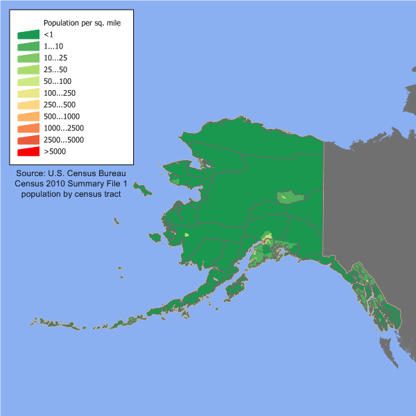
English: Alaska state population density map based on Census 2010 data. See the data lineage for a process description. |
| ရက်စွဲ | ၂၀ မတ် ၂၀၀၆ (original upload date) |
| ရင်းမြစ် | Transferred from en.wikipedia to Commons. |
| စာရေးသူ | JimIrwin at အင်္ဂလိပ် ဝီကီပီးဒီးယား |
လိုင်စင်သတ်မှတ်ခြင်း
JimIrwin from en.wikipedia.org၊ ဤလုပ်ဆောင်ချက်၏ မူပိုင်ခွင့်ပိုင်ရှင်အနေဖြင့် ဤနေရာမှ အောက်ပါလိုင်စင်အောက်တွင် ထုတ်လွှင့်ပါသည်:

|
ဤစာတမ်းကို GNU Free Documentation License, ဗားရှင်း ၁.၂ သို့မဟုတ် Free Software Foundation မှ ဖြန့်ချီထားသော မည်သည့်ယခင်ဗားရှင်းတစ်ခုခုအောက်တွင် Invariant Sections, Front-Cover Texts နှင့် Back-Cover Texts များမပါဝင်ဘဲ ကူးယူခြင်း၊ ဖြန့်ချီခြင်း နှင့်/သို့မဟုတ် ပြင်ဆင်ပြောင်းလဲနိုင်ရန် ခွင့်ပြုသည်။ လိုင်စင်မူပွားကို GNU Free Documentation License ခေါင်းစဉ်အောက်တွင် ထည့်သွင်းထားသည်။ |
| ဤဖိုင်ကို Creative Commons Attribution-Share Alike 3.0 Unported လိုင်စင်ဖြင့် သတ်မှတ်ထားသည်။ | ||
| မှတ်ယူနိုင်ခြင်း: JimIrwin | ||
| ||
| This licensing tag was added to this file as part of the GFDL licensing update. |
မူရင်းတင်ထားသောမှတ်တမ်း
ဖော်ပြချက် မူရင်းစာမျက်နှာမှာ here ဖြစ်သည်။ အောက်ပါအသုံးပြုသူ အမည်များအားလုံးသည် en.wikipedia ကို ရည်ညွှန်းသည်။
- 2006-03-20 12:37 JimIrwin 700×460×8 (22678 bytes) [[Category:U.S. State Population Maps]] [[Category:Alaska maps]] Alaska state population density map based on Census 2000 data. See the [[User:JimIrwin/Lineage_of_population_maps|data lineage]] for a process description.
ဖိုင်မှတ်တမ်း
ဖိုင်ကို ယင်းနေ့စွဲ အတိုင်း မြင်နိုင်ရန် နေ့စွဲ/အချိန် တစ်ခုခုပေါ်တွင် ကလစ်နှိပ်ပါ။
| နေ့စွဲ/အချိန် | နမူနာပုံငယ် | မှတ်တမ်း ဒိုင်မန်းရှင်းများ | အသုံးပြုသူ | မှတ်ချက် | |
|---|---|---|---|---|---|
| ကာလပေါ် | ၁၃:၅၆၊ ၁၁ ဒီဇင်ဘာ ၂၀၁၁ | | ၆၀၀ × ၆၀၀ (၉၇ KB) | JimIrwin | 2010 census update |
| ၁၈:၄၁၊ ၂၀ ဧပြီ ၂၀၀၈ |  | ၇၀၀ × ၄၆၀ (၂၂ KB) | File Upload Bot (Magnus Manske) | {{BotMoveToCommons|en.wikipedia}} {{Information |Description={{en|en:Category:U.S. State Population Maps en:Category:Alaska maps Alaska state population density map based on Census 2000 data. See the [[:en:User:JimIrwin/Lineage_of_population_m |
ဖိုင်သုံးစွဲမှု
အောက်ပါ စာမျက်နှာ သည် ဤဖိုင်ကို အသုံးပြုထားသည်:
ဂလိုဘယ် ဖိုင်သုံးစွဲမှု
အောက်ပါ အခြားဝီကီများတွင် ဤဖိုင်ကို အသုံးပြုထားသည်-
- cs.wikipedia.org တွင် အသုံးပြုမှု
- de.wikipedia.org တွင် အသုံးပြုမှု
- en.wikipedia.org တွင် အသုံးပြုမှု
- es.wikipedia.org တွင် အသုံးပြုမှု
- fr.wikipedia.org တွင် အသုံးပြုမှု
- fy.wikipedia.org တွင် အသုံးပြုမှု
- he.wikipedia.org တွင် အသုံးပြုမှု
- ro.wikipedia.org တွင် အသုံးပြုမှု
- Categorie:Statul Alaska, SUA
- Alaska
- Alaska (dezambiguizare)
- Format:Alaska stat SUA
- Alaska (teritoriu SUA)
- Juneau, Alaska
- Strâmtoarea Bering
- Listă de comitate (boroughs și census areas) din statul Alaska
- Anchorage, Alaska
- Categorie:Formate Alaska
- Categorie:Oameni din Alaska
- Insulele Aleutine
- Categorie:Membri ai Senatului SUA din statul Alaska
- Denali
- Categorie:Boroughs din statul Alaska, SUA
- Peninsula Alaska
- Categorie:Liste Alaska
- Wasilla, Alaska
- Categorie:Teritoriul Alaska
- Listă de munți din Alaska
- Fairbanks, Alaska
- Alaska Interior
- Listă de guvernatori ai statului Alaska, Statele Unite ale Americii
- Sitka, Alaska
- Categorie:Juneau, Alaska
- Categorie:Wasilla, Alaska
- Parcul Național Wrangell-St.-Elias
- Insula Wrangell
- Listă de oameni din statul Alaska
- Categorie:Guvernul statului Alaska
- Listă de orașe din statul Alaska
- Categorie:Zone metropolitane din Alaska
- Categorie:Zone micropolitane din Alaska
- Categorie:Localități din Alaska
- Categorie:Munți din Alaska
- Kodiak, Alaska
- Categorie:Forme de relief din Alaska
- Categorie:Cultura statului Alaska
- Categorie:Politicieni din statul Alaska
- Categorie:Regiuni ale statului Alaska
- Categorie:Dezastre naturale din statul Alaska
ဤဖိုင်ကို အခြားနေရာများတွင် အသုံးပြုထားမှုများအား ကြည့်ရှုရန်။