ဖိုင်:Arctic.svg

Size of this PNG preview of this SVG file: ၄၇၈ × ၅၉၉ ပစ်ဇယ်. အခြား ပုံရိပ်ပြတ်သားမှု: ၁၉၁ × ၂၄၀ ပစ်ဇယ် | ၃၈၃ × ၄၈၀ ပစ်ဇယ် | ၆၁၃ × ၇၆၈ ပစ်ဇယ် | ၈၁၇ × ၁၀၂၄ ပစ်ဇယ် | ၁၆၃၄ × ၂၀၄၈ ပစ်ဇယ် | ၅၀၅ × ၆၃၃ ပစ်ဇယ်။
မူရင်းဖိုင် (SVG ဖိုင်, ၅၀၅ × ၆၃၃ pixels ကို အကြံပြုသည်, ဖိုင်အရွယ်အစား - ၁.၅ MB)
| ဤဖိုင်သည် Wikimedia Commons မှဖြစ်ပြီး အခြားပရောဂျက်များတွင် သုံးကောင်းသုံးလိမ့်မည်။ ယင်း၏ ဖိုင်အကြောင်းစာမျက်နှာ တွင် ဖော်ပြထားချက်ကို အောက်တွင် ပြထားသည်။ Commons သည် မူပိုင်ခွင့်လွတ်လပ်သော မီဒီယာဖိုင်များ သိုလှောင်ထားရာ နေရာ ဖြစ်သည်။ သင်လည်း ပါဝင်ကူညီနိုင်ပါသည်။ |
အကျဉ်းချုပ်
| ဖော်ပြချက် |
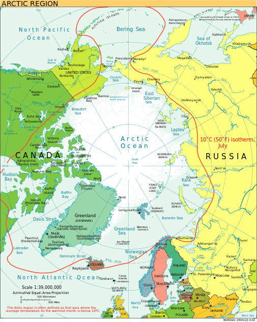
English: A view of the Arctic. The 10 °C (50 °F) mean isotherm in July line, displayed red, is commonly used to define the border of the Arctic region. |
| ရက်စွဲ | ဖေဖော်ဝါရီ ၂၀၁၃ (original upload date) |
| ရင်းမြစ် | CIA World Factbook |
| စာရေးသူ | CIA World Factbook |
| အခြား ဗားရှင်းများ |
[]
|


.svg)


|
This SVG file contains embedded text that can be translated into your language, using any capable SVG editor, text editor or the SVG Translate tool. For more information see: About translating SVG files. |
လိုင်စင်သတ်မှတ်ခြင်း
This image is in the public domain because it contains materials that originally came from the United States Central Intelligence Agency's World Factbook.
|
 |
ဖိုင်မှတ်တမ်း
ဖိုင်ကို ယင်းနေ့စွဲ အတိုင်း မြင်နိုင်ရန် နေ့စွဲ/အချိန် တစ်ခုခုပေါ်တွင် ကလစ်နှိပ်ပါ။
| နေ့စွဲ/အချိန် | နမူနာပုံငယ် | မှတ်တမ်း ဒိုင်မန်းရှင်းများ | အသုံးပြုသူ | မှတ်ချက် | |
|---|---|---|---|---|---|
| ကာလပေါ် | ၂၁:၀၀၊ ၁၁ ဩဂုတ် ၂၀၂၃ | | ၅၀၅ × ၆၃၃ (၁.၅ MB) | Mahagaja | correct spelling of Kangiqliniq |
| ၁၈:၂၉၊ ၉ ဩဂုတ် ၂၀၀၉ |  | ၅၀၅ × ၆၃၃ (၁.၅ MB) | Ysangkok | compact code, no visible changes afaik | |
| ၂၃:၃၄၊ ၁၉ ဩဂုတ် ၂၀၀၇ |  | ၅၀၅ × ၆၃၃ (၁.၆၃ MB) | StephenHudson | Reverted to earlier revision | |
| ၂၂:၁၈၊ ၁၉ ဩဂုတ် ၂၀၀၇ |  | ၁၀၁၀ × ၁၂၆၇ (၁.၄ MB) | StephenHudson | Increased base pixel size to make text readable. | |
| ၁၇:၁၇၊ ၂၄ ဇန်နဝါရီ ၂၀၀၆ |  | ၅၀၅ × ၆၃၃ (၁.၆၃ MB) | Moyogo | stripped useless stuff | |
| ၂၀:၃၂၊ ၂၃ ဇန်နဝါရီ ၂၀၀၆ |  | ၅၀၅ × ၆၃၃ (၁.၉၅ MB) | Sanao | Arctic<br /> Origin : CIA World Factbook Category:SVG maps Category:Arctic |
ဖိုင်သုံးစွဲမှု
ဤဖိုင်ကို အသုံးပြုထားသော စာမျက်နှာများမရှိပါ။
ဂလိုဘယ် ဖိုင်သုံးစွဲမှု
အောက်ပါ အခြားဝီကီများတွင် ဤဖိုင်ကို အသုံးပြုထားသည်-
- ace.wikipedia.org တွင် အသုံးပြုမှု
- ady.wikipedia.org တွင် အသုံးပြုမှု
- af.wikipedia.org တွင် အသုံးပြုမှု
- ar.wikipedia.org တွင် အသုံးပြုမှု
- arz.wikipedia.org တွင် အသုံးပြုမှု
- ast.wikipedia.org တွင် အသုံးပြုမှု
- as.wikipedia.org တွင် အသုံးပြုမှု
- ba.wikipedia.org တွင် အသုံးပြုမှု
- bg.wikipedia.org တွင် အသုံးပြုမှု
- bn.wikipedia.org တွင် အသုံးပြုမှု
- ca.wikipedia.org တွင် အသုံးပြုမှု
- cy.wikipedia.org တွင် အသုံးပြုမှု
- da.wikipedia.org တွင် အသုံးပြုမှု
- da.wiktionary.org တွင် အသုံးပြုမှု
- de.wikipedia.org တွင် အသုံးပြုမှု
- dty.wikipedia.org တွင် အသုံးပြုမှု
- el.wikipedia.org တွင် အသုံးပြုမှု
- en.wikipedia.org တွင် အသုံးပြုမှု
- Geography of Denmark
- Jan Mayen
- Svalbard
- Northern Canada
- History of Svalbard
- Contour line
- List of rivers of the Americas by coastline
- Arctic Bridge
- History of the petroleum industry in Canada (frontier exploration and development)
- Portal:Maps/Maps/Nautical
- Portal:Maps/Maps/Nautical/2
- Arctic Ocean
- Wikipedia:Graphics Lab/Map workshop/Archive/Aug 2009
- Sir James Lamont, 1st Baronet
- Arctic exploration
- en.wikibooks.org တွင် အသုံးပြုမှု
- eo.wikipedia.org တွင် အသုံးပြုမှု
- eo.wiktionary.org တွင် အသုံးပြုမှု
- es.wikipedia.org တွင် အသုံးပြုမှု
ဤဖိုင်ကို အခြားနေရာများတွင် အသုံးပြုထားမှုများအား ကြည့်ရှုရန်။