ဖိုင်:British Overseas.png

ဤနမူနာ၏ အရွယ်အစား - ၇၂၅ × ၅၉၉ ပစ်ဇယ်။ အခြား ပုံရိပ်ပြတ်သားမှု: ၂၉၀ × ၂၄၀ ပစ်ဇယ် | ၅၈၁ × ၄၈၀ ပစ်ဇယ် | ၉၂၉ × ၇၆၈ ပစ်ဇယ် | ၁၂၃၉ × ၁၀၂၄ ပစ်ဇယ် | ၂၄၇၈ × ၂၀၄၈ ပစ်ဇယ် | ၂၇၆၈ × ၂၂၈၈ ပစ်ဇယ်။
မူရင်းဖိုင် (၂၇၆၈ × ၂၂၈၈ pixels, ဖိုင်အရွယ်အစား - ၄၉၁ KB, MIME အမျိုးအစား image/png)
| ဤဖိုင်သည် Wikimedia Commons မှဖြစ်ပြီး အခြားပရောဂျက်များတွင် သုံးကောင်းသုံးလိမ့်မည်။ ယင်း၏ ဖိုင်အကြောင်းစာမျက်နှာ တွင် ဖော်ပြထားချက်ကို အောက်တွင် ပြထားသည်။ Commons သည် မူပိုင်ခွင့်လွတ်လပ်သော မီဒီယာဖိုင်များ သိုလှောင်ထားရာ နေရာ ဖြစ်သည်။ သင်လည်း ပါဝင်ကူညီနိုင်ပါသည်။ |
အကျဉ်းချုပ်
| ဖော်ပြချက် |
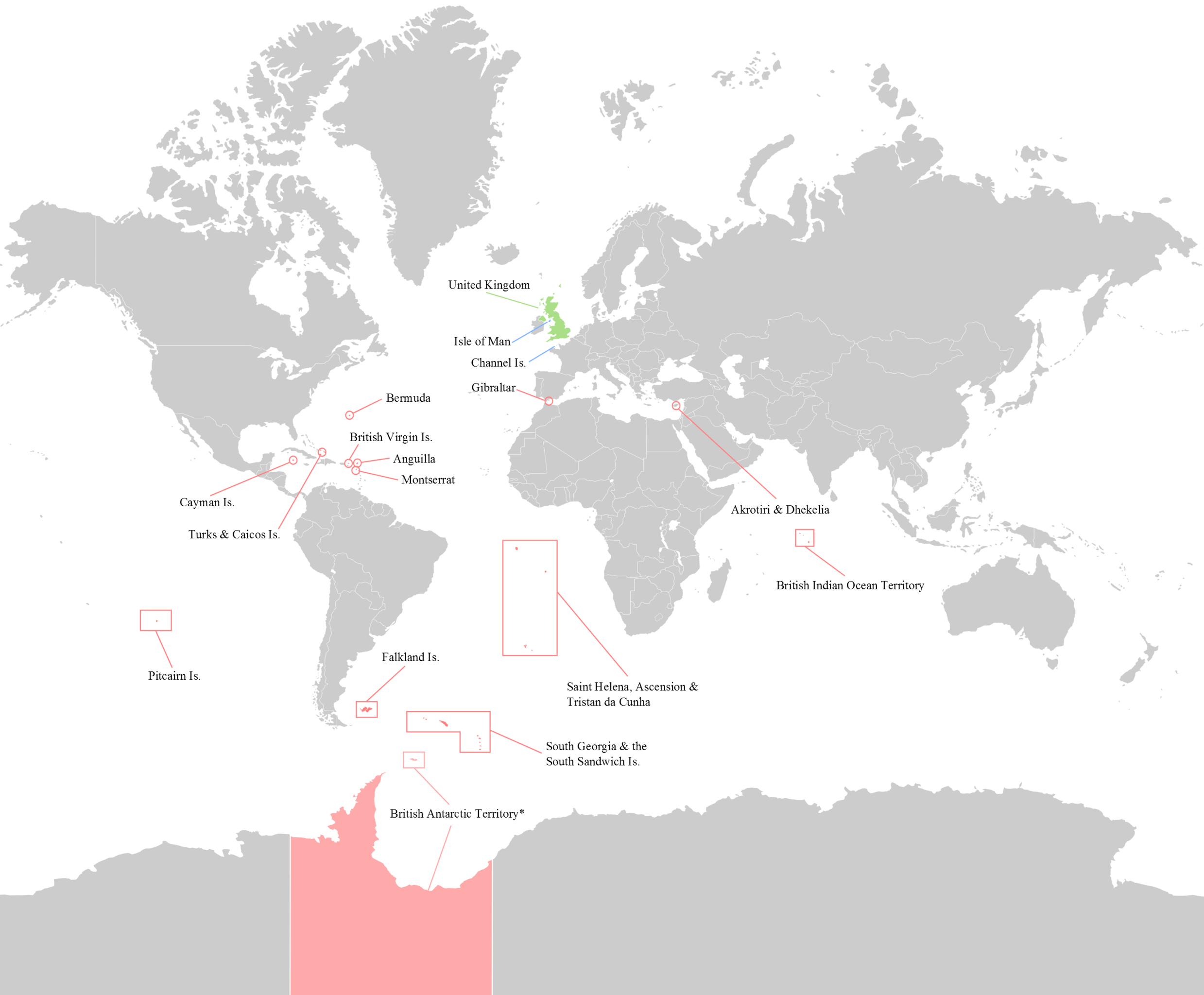
English: Map of the 14 current (2012) British Overseas Territories. Antarctica - where sovereignty is suspended is slightly lighter.
British Overseas Territories United Kingdom Crown Dependencies |
| ရက်စွဲ | |
| ရင်းမြစ် | ကိုယ်ပိုင်ဖန်တီးမှု |
| စာရေးသူ | George Bozanko |

|
This locator map image could be re-created using vector graphics as an SVG file. This has several advantages; see Commons:Media for cleanup for more information. If an SVG form of this image is available, please upload it and afterwards replace this template with
{{vector version available|new image name}}.
It is recommended to name the SVG file “British Overseas.svg”—then the template Vector version available (or Vva) does not need the new image name parameter. |
လိုင်စင်သတ်မှတ်ခြင်း
ကျွန်ုပ်၊ ဤလုပ်ဆောင်ချက်၏ မူပိုင်ခွင့်ပိုင်ရှင်အနေဖြင့် ဤနေရာမှ အောက်ပါလိုင်စင်အောက်တွင် ထုတ်လွှင့်ပါသည်:
ဤဖိုင်ကို Creative Commons Attribution-Share Alike 3.0 Unported လိုင်စင်ဖြင့် သတ်မှတ်ထားသည်။
- သင်သည် လွတ်လပ်စွာ:
- မျှဝေရန် – ဖန်တီးမှုကို ကူးယူရန်၊ ဖြန့်ဖြူးရန်နှင့် ထုတ်လွှင့်ရန်
- ပြန်ရောနှောရန် – ဖန်တီးမှုကို ပြင်ဆင်ညှိနှိုင်းရန်
- အောက်ပါ အခြေအနေများတွင်:
- မှတ်ယူနိုင်ခြင်း – ပြောင်းလဲမှုများ ပြုလုပ်ခဲ့ပါက ဖန်တီးသူ သို့မဟုတ် လိုင်စင်ရှိသူမှ သတ်မှတ်သော အမျိုးအစားကို လိုက်နာရမည် (ဆိုလိုသည်မှာ သင့်အား သို့မဟုတ် သင့်ဖန်တီးမှုတွင် အသုံးပြုခြင်းအား ထောက်ခံချက်ပေးသည်ဟု မဆိုလိုပါ)။
- ထပ်တူမျှဝေ – ဤဖန်တီးမှုအား ပြင်ဆင်ခြင်း၊ ပြောင်းလဲခြင်း သို့မဟုတ် ထပ်ဆင့် ဖန်တီးခြင်း ပြုလုပ်ပါက ရရှိလာသော ဖန်တီးမှုကို ဤဖန်တီးမှုနှင့် သို့မဟုတ် ဆင်တူသော လိုင်စင်ဖြင့်သာ ဖြန့်ချိသင့်သည်။
ဖိုင်မှတ်တမ်း
ဖိုင်ကို ယင်းနေ့စွဲ အတိုင်း မြင်နိုင်ရန် နေ့စွဲ/အချိန် တစ်ခုခုပေါ်တွင် ကလစ်နှိပ်ပါ။
| နေ့စွဲ/အချိန် | နမူနာပုံငယ် | မှတ်တမ်း ဒိုင်မန်းရှင်းများ | အသုံးပြုသူ | မှတ်ချက် | |
|---|---|---|---|---|---|
| ကာလပေါ် | ၁၅:၅၂၊ ၂၀ ဩဂုတ် ၂၀၁၆ | | ၂၇၆၈ × ၂၂၈၈ (၄၉၁ KB) | Rob984 | Removed title, border, compass, and duplicated area at either side of the map |
| ၁၈:၂၅၊ ၁၀ ဩဂုတ် ၂၀၁၄ |  | ၃၀၀၀ × ၂၃၀၀ (၅၄၆ KB) | RomanLier | Reverted to version as of 17:12, 3 June 2012 | |
| ၂၂:၂၂၊ ၉ ဩဂုတ် ၂၀၁၄ |  | ၇၈၂ × ၆၀၀ (၁၄၂ KB) | RomanLier | Reverted to version as of 22:21, 9 August 2014 | |
| ၂၂:၂၁၊ ၉ ဩဂုတ် ၂၀၁၄ |  | ၇၈၂ × ၆၀၀ (၁၄၂ KB) | RomanLier | Wrong information was corrected. | |
| ၂၂:၂၁၊ ၉ ဩဂုတ် ၂၀၁၄ |  | ၇၈၂ × ၆၀၀ (၁၄၂ KB) | RomanLier | Wrong information was corrected. | |
| ၁၇:၁၂၊ ၃ ဇွန် ၂၀၁၂ |  | ၃၀၀၀ × ၂၃၀၀ (၅၄၆ KB) | GBozanko | Removal of Colonial borders that were left in map after previous edit. | |
| ၁၁:၂၄၊ ၁ ဇွန် ၂၀၁၂ |  | ၃၀၀၀ × ၂၄၀၀ (၅၅၁ KB) | GBozanko | Fix to dimensions and South Orkney colour. | |
| ၀၀:၃၉၊ ၁ ဇွန် ၂၀၁၂ |  | ၃၀၀၂ × ၂၄၀၈ (၆၁၀ KB) | GBozanko |
ဖိုင်သုံးစွဲမှု
အောက်ပါ စာမျက်နှာ သည် ဤဖိုင်ကို အသုံးပြုထားသည်:
ဂလိုဘယ် ဖိုင်သုံးစွဲမှု
အောက်ပါ အခြားဝီကီများတွင် ဤဖိုင်ကို အသုံးပြုထားသည်-
- arz.wikipedia.org တွင် အသုံးပြုမှု
- azb.wikipedia.org တွင် အသုံးပြုမှု
- bn.wikipedia.org တွင် အသုံးပြုမှု
- cv.wikipedia.org တွင် အသုံးပြုမှု
- el.wikipedia.org တွင် အသုံးပြုမှု
- en.wikipedia.org တွင် အသုံးပြုမှု
- fr.wikipedia.org တွင် အသုံးပြုမှု
- gl.wikipedia.org တွင် အသုံးပြုမှု
- he.wikipedia.org တွင် အသုံးပြုမှု
- ja.wikipedia.org တွင် အသုံးပြုမှု
- lld.wikipedia.org တွင် အသုံးပြုမှု
- lt.wikipedia.org တွင် အသုံးပြုမှု
- lv.wikipedia.org တွင် အသုံးပြုမှု
- ne.wikipedia.org တွင် အသုံးပြုမှု
- or.wikipedia.org တွင် အသုံးပြုမှု
- pa.wikipedia.org တွင် အသုံးပြုမှု
- pnb.wikipedia.org တွင် အသုံးပြုမှု
- pt.wikipedia.org တွင် အသုံးပြုမှု
- pt.wikinews.org တွင် အသုံးပြုမှု
- sr.wikipedia.org တွင် အသုံးပြုမှု
- ta.wikipedia.org တွင် အသုံးပြုမှု
- ur.wikipedia.org တွင် အသုံးပြုမှု
- zh-yue.wikipedia.org တွင် အသုံးပြုမှု