ဖိုင်:Bundesarchiv Bild 183-L09218, Berlin, Japanische Botschaft.jpg
ဤနမူနာ၏ အရွယ်အစား - ၄၄၈ × ၆၀၀ ပစ်ဇယ်။ အခြား ပုံရိပ်ပြတ်သားမှု: ၁၇၉ × ၂၄၀ ပစ်ဇယ် | ၅၆၇ × ၇၅၉ ပစ်ဇယ်။
မူရင်းဖိုင် (၅၆၇ × ၇၅၉ pixels, ဖိုင်အရွယ်အစား - ၉၇ KB, MIME အမျိုးအစား image/jpeg)
| ဤဖိုင်သည် Wikimedia Commons မှဖြစ်ပြီး အခြားပရောဂျက်များတွင် သုံးကောင်းသုံးလိမ့်မည်။ ယင်း၏ ဖိုင်အကြောင်းစာမျက်နှာ တွင် ဖော်ပြထားချက်ကို အောက်တွင် ပြထားသည်။ Commons သည် မူပိုင်ခွင့်လွတ်လပ်သော မီဒီယာဖိုင်များ သိုလှောင်ထားရာ နေရာ ဖြစ်သည်။ သင်လည်း ပါဝင်ကူညီနိုင်ပါသည်။ |
အကျဉ်းချုပ်
| Photographer |
မသိရှိရ |
||||||||||||||||||||||||||
| Original caption |
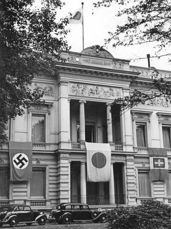
For documentary purposes the German Federal Archive often retained the original image captions, which may be erroneous, biased, obsolete or politically extreme. Berlin, Japanische Botschaft
ADN-ZB Berlin 1940: Im faschistischen Deutschland. Die japanische Botschaft in der Tiergartenstraße. 8309-40 [Berlin.- Japanische Botschaft in der Tiergartenstraße mit Hakenkreuzflagge, Flagge des Kaiserreichs Japan und Italien] |
||||||||||||||||||||||||||
| Depicted place | ဘာလင်မြို့ | ||||||||||||||||||||||||||
| ရက်စွဲ | စက်တင်ဘာ ၁၉၄၀ | ||||||||||||||||||||||||||
| Collection |
|
||||||||||||||||||||||||||
| လက်ရှိ တည်နေရာ |
Allgemeiner Deutscher Nachrichtendienst - Zentralbild (Bild 183) |
||||||||||||||||||||||||||
| Accession number | |||||||||||||||||||||||||||
| ရင်းမြစ် |
|
||||||||||||||||||||||||||

English: In fascist Germany, the Japanese Embassy on Tiergartenstraße with the Nazi Flag, the Japanese Imperial Flag, and the Italian Flag
လိုင်စင်သတ်မှတ်ခြင်း
ဤဖိုင်သည် Creative Commons Attribution-Share Alike 3.0 ဂျာမနီ လိုင်စင်အောက်တွင် လိုင်စင်သတ်မှတ်ထားပါသည်။
မှတ်ယူနိုင်ခြင်း: Bundesarchiv, Bild 183-L09218 / CC-BY-SA 3.0
- သင်သည် လွတ်လပ်စွာ:
- မျှဝေရန် – ဖန်တီးမှုကို ကူးယူရန်၊ ဖြန့်ဖြူးရန်နှင့် ထုတ်လွှင့်ရန်
- ပြန်ရောနှောရန် – ဖန်တီးမှုကို ပြင်ဆင်ညှိနှိုင်းရန်
- အောက်ပါ အခြေအနေများတွင်:
- မှတ်ယူနိုင်ခြင်း – ပြောင်းလဲမှုများ ပြုလုပ်ခဲ့ပါက ဖန်တီးသူ သို့မဟုတ် လိုင်စင်ရှိသူမှ သတ်မှတ်သော အမျိုးအစားကို လိုက်နာရမည် (ဆိုလိုသည်မှာ သင့်အား သို့မဟုတ် သင့်ဖန်တီးမှုတွင် အသုံးပြုခြင်းအား ထောက်ခံချက်ပေးသည်ဟု မဆိုလိုပါ)။
- ထပ်တူမျှဝေ – ဤဖန်တီးမှုအား ပြင်ဆင်ခြင်း၊ ပြောင်းလဲခြင်း သို့မဟုတ် ထပ်ဆင့် ဖန်တီးခြင်း ပြုလုပ်ပါက ရရှိလာသော ဖန်တီးမှုကို ဤဖန်တီးမှုနှင့် သို့မဟုတ် ဆင်တူသော လိုင်စင်ဖြင့်သာ ဖြန့်ချိသင့်သည်။

| Object location | | View this and other nearby images on: OpenStreetMap |
|---|
| Camera location | | View this and other nearby images on: OpenStreetMap |
|---|
ဖိုင်မှတ်တမ်း
ဖိုင်ကို ယင်းနေ့စွဲ အတိုင်း မြင်နိုင်ရန် နေ့စွဲ/အချိန် တစ်ခုခုပေါ်တွင် ကလစ်နှိပ်ပါ။
| နေ့စွဲ/အချိန် | နမူနာပုံငယ် | မှတ်တမ်း ဒိုင်မန်းရှင်းများ | အသုံးပြုသူ | မှတ်ချက် | |
|---|---|---|---|---|---|
| ကာလပေါ် | ၀၃:၄၇၊ ၂၄ အောက်တိုဘာ ၂၀၁၂ | | ၅၆၇ × ၇၅၉ (၉၇ KB) | Cropbot | upload cropped version, operated by User:jay8g. Summary: cropped |
| ၁၇:၃၃၊ ၄ ဒီဇင်ဘာ ၂၀၀၈ |  | ၅၉၂ × ၈၀၀ (၁၀၆ KB) | BArchBot | == Summary == {{Information |Description={{de|1='''Berlin, Japanische Botschaft''' ADN-ZB Berlin 1940: Im faschistischen Deutschland. Die japanische Botschaft in der Tiergartenstraße. 8309-40 [Berlin.- Japanische Botschaft in der Tiergartenstraße mit |
ဖိုင်သုံးစွဲမှု
အောက်ပါ စာမျက်နှာ သည် ဤဖိုင်ကို အသုံးပြုထားသည်:
ဂလိုဘယ် ဖိုင်သုံးစွဲမှု
အောက်ပါ အခြားဝီကီများတွင် ဤဖိုင်ကို အသုံးပြုထားသည်-
- ar.wikipedia.org တွင် အသုံးပြုမှု
- ast.wikipedia.org တွင် အသုံးပြုမှု
- azb.wikipedia.org တွင် အသုံးပြုမှု
- az.wikipedia.org တွင် အသုံးပြုမှု
- bg.wikipedia.org တွင် အသုံးပြုမှု
- ca.wikipedia.org တွင် အသုံးပြုမှု
- cs.wikipedia.org တွင် အသုံးပြုမှု
- da.wikipedia.org တွင် အသုံးပြုမှု
- de.wikipedia.org တွင် အသုံးပြုမှု
- el.wikipedia.org တွင် အသုံးပြုမှု
- en.wikipedia.org တွင် အသုံးပြုမှု
- en.wikiquote.org တွင် အသုံးပြုမှု
- eo.wikipedia.org တွင် အသုံးပြုမှု
- es.wikipedia.org တွင် အသုံးပြုမှု
- fa.wikipedia.org တွင် အသုံးပြုမှု
- fr.wikipedia.org တွင် အသုံးပြုမှု
- gv.wikipedia.org တွင် အသုံးပြုမှု
- he.wikipedia.org တွင် အသုံးပြုမှု
- hi.wikipedia.org တွင် အသုံးပြုမှု
- hy.wikipedia.org တွင် အသုံးပြုမှု
- id.wikipedia.org တွင် အသုံးပြုမှု
- it.wikipedia.org တွင် အသုံးပြုမှု
- ja.wikipedia.org တွင် အသုံးပြုမှု
ဤဖိုင်ကို အခြားနေရာများတွင် အသုံးပြုထားမှုများအား ကြည့်ရှုရန်။