ဖိုင်:FAA JFK Airport map 2016.pdf
Size of this JPG preview of this PDF file: ၃၉၀ × ၅၉၉ ပစ်ဇယ်. အခြား ပုံရိပ်ပြတ်သားမှု: ၁၅၆ × ၂၄၀ ပစ်ဇယ် | ၃၁၃ × ၄၈၀ ပစ်ဇယ် | ၈၀၆ × ၁၂၃၇ ပစ်ဇယ်။
မူရင်းဖိုင် (၈၀၆ × ၁၂၃၇ pixels, ဖိုင်အရွယ်အစား - ၂၄၀ KB, MIME အမျိုးအစား application/pdf)
| ဤဖိုင်သည် Wikimedia Commons မှဖြစ်ပြီး အခြားပရောဂျက်များတွင် သုံးကောင်းသုံးလိမ့်မည်။ ယင်း၏ ဖိုင်အကြောင်းစာမျက်နှာ တွင် ဖော်ပြထားချက်ကို အောက်တွင် ပြထားသည်။ Commons သည် မူပိုင်ခွင့်လွတ်လပ်သော မီဒီယာဖိုင်များ သိုလှောင်ထားရာ နေရာ ဖြစ်သည်။ သင်လည်း ပါဝင်ကူညီနိုင်ပါသည်။ |
အကျဉ်းချုပ်
| ဖော်ပြချက် |
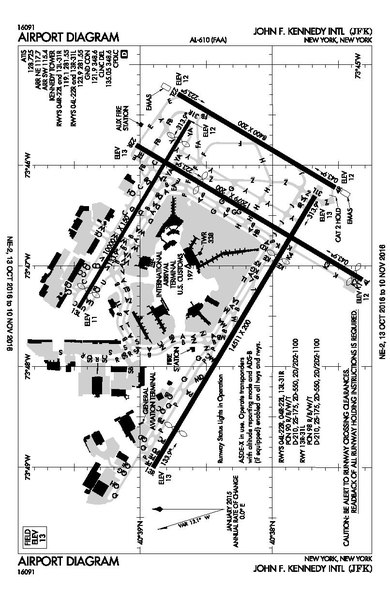
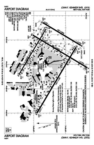
English: Aiport diagram of John F. Kennedy International aiport, as published by the FAA, containing runway and taxiway information among other aeronautical markers. |
| ရက်စွဲ | |
| ရင်းမြစ် | https://www.faa.gov/airports/runway_safety/diagrams/ |
| စာရေးသူ | Federal Aviation Administration |
| Camera location | | View this and other nearby images on: OpenStreetMap |
|---|
လိုင်စင်သတ်မှတ်ခြင်း
This image or file is a work of a Federal Aviation Administration employee, taken or made as part of that person's official duties. As a work of the U.S. federal government, the image is in the public domain in the United States.
|
 |
ဖိုင်မှတ်တမ်း
ဖိုင်ကို ယင်းနေ့စွဲ အတိုင်း မြင်နိုင်ရန် နေ့စွဲ/အချိန် တစ်ခုခုပေါ်တွင် ကလစ်နှိပ်ပါ။
| နေ့စွဲ/အချိန် | နမူနာပုံငယ် | မှတ်တမ်း ဒိုင်မန်းရှင်းများ | အသုံးပြုသူ | မှတ်ချက် | |
|---|---|---|---|---|---|
| ကာလပေါ် | ၀၅:၀၉၊ ၂၈ အောက်တိုဘာ ၂၀၁၆ |  | ၈၀၆ × ၁၂၃၇ (၂၄၀ KB) | Parent5446 | User created page with UploadWizard |
ဖိုင်သုံးစွဲမှု
အောက်ပါ စာမျက်နှာ သည် ဤဖိုင်ကို အသုံးပြုထားသည်:
ဂလိုဘယ် ဖိုင်သုံးစွဲမှု
အောက်ပါ အခြားဝီကီများတွင် ဤဖိုင်ကို အသုံးပြုထားသည်-
- af.wikipedia.org တွင် အသုံးပြုမှု
- en.wikipedia.org တွင် အသုံးပြုမှု
- ml.wikipedia.org တွင် အသုံးပြုမှု
- simple.wikipedia.org တွင် အသုံးပြုမှု
- ur.wikipedia.org တွင် အသုံးပြုမှု
- www.wikidata.org တွင် အသုံးပြုမှု