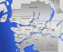
ဖိုင်:GVA-map.png

ဤနမူနာ၏ အရွယ်အစား - ၇၂၄ × ၆၀၀ ပစ်ဇယ်။ အခြား ပုံရိပ်ပြတ်သားမှု: ၂၉၀ × ၂၄၀ ပစ်ဇယ် | ၅၇၉ × ၄၈၀ ပစ်ဇယ် | ၈၄၆ × ၇၀၁ ပစ်ဇယ်။
မူရင်းဖိုင် (၈၄၆ × ၇၀၁ pixels, ဖိုင်အရွယ်အစား - ၂၂၃ KB, MIME အမျိုးအစား image/png)
ဖိုင်မှတ်တမ်း
ဖိုင်ကို ယင်းနေ့စွဲ အတိုင်း မြင်နိုင်ရန် နေ့စွဲ/အချိန် တစ်ခုခုပေါ်တွင် ကလစ်နှိပ်ပါ။
| နေ့စွဲ/အချိန် | နမူနာပုံငယ် | မှတ်တမ်း ဒိုင်မန်းရှင်းများ | အသုံးပြုသူ | မှတ်ချက် | |
|---|---|---|---|---|---|
| ကာလပေါ် | ၂၁:၀၇၊ ၂ ဇန်နဝါရီ ၂၀၀၇ |  | ၈၄၆ × ၇၀၁ (၂၂၃ KB) | Qyd | pale sea |
| ၂၀:၂၅၊ ၂ ဇန်နဝါရီ ၂၀၀၇ |  | ၈၄၆ × ၇၀၁ (၂၃၁ KB) | Qyd | {{Information |Description=Blank map of the Greater Vancouver Area, [[British Columbia, Canada |Source=GIS data |Date=Jan 2007 |Author={{User|Qyd}} |Permission=All |other_versions=Image:Greater Vancouver Area.png (with municipalities names) } |
ဖိုင်သုံးစွဲမှု
ဤဖိုင်ကို အသုံးပြုထားသော စာမျက်နှာများမရှိပါ။
ဂလိုဘယ် ဖိုင်သုံးစွဲမှု
အောက်ပါ အခြားဝီကီများတွင် ဤဖိုင်ကို အသုံးပြုထားသည်-
- ar.wikipedia.org တွင် အသုံးပြုမှု
- en.wikipedia.org တွင် အသုံးပြုမှု
- eo.wikipedia.org တွင် အသုံးပြုမှု
- fa.wikipedia.org တွင် အသုံးပြုမှု
- الگو:Location map Canada Vancouver
- فرودگاه بینالمللی آبی ونکوور
- الگو:Location map Canada Vancouver/توضیحات
- الگو:Location map Canada Vancouver/doc
- بیمارستان زنان و مرکز سلامت بی.سی.
- موزه مردمشناسی دانشگاه بریتیش کلمبیا
- مترو ونکوور
- انگلیش بی، ونکوور
- پل لاینز گیت
- گستاون
- گالری هنر ونکوور
- متروتاون، برنابی
- رنفرو–کولینگوود
- fr.wikipedia.org တွင် အသုံးပြုမှု
- id.wikipedia.org တွင် အသုံးပြုမှု
- ja.wikipedia.org တွင် အသုံးပြုမှု
- kn.wikipedia.org တွင် အသုံးပြုမှု
- pl.wikipedia.org တွင် အသုံးပြုမှု
ဤဖိုင်ကို အခြားနေရာများတွင် အသုံးပြုထားမှုများအား ကြည့်ရှုရန်။


