ဖိုင်:Lake Nasser location.png
Lake_Nasser_location.png (၆၀၀ × ၅၇၀ pixels, ဖိုင်အရွယ်အစား - ၁၁၃ KB, MIME အမျိုးအစား image/png)
| ဤဖိုင်သည် Wikimedia Commons မှဖြစ်ပြီး အခြားပရောဂျက်များတွင် သုံးကောင်းသုံးလိမ့်မည်။ ယင်း၏ ဖိုင်အကြောင်းစာမျက်နှာ တွင် ဖော်ပြထားချက်ကို အောက်တွင် ပြထားသည်။ Commons သည် မူပိုင်ခွင့်လွတ်လပ်သော မီဒီယာဖိုင်များ သိုလှောင်ထားရာ နေရာ ဖြစ်သည်။ သင်လည်း ပါဝင်ကူညီနိုင်ပါသည်။ |

|
This map image could be re-created using vector graphics as an SVG file. This has several advantages; see Commons:Media for cleanup for more information. If an SVG form of this image is available, please upload it and afterwards replace this template with
{{vector version available|new image name}}.
It is recommended to name the SVG file “Lake Nasser location.svg”—then the template Vector version available (or Vva) does not need the new image name parameter. |
အကျဉ်းချုပ်
- သင်သည် လွတ်လပ်စွာ:
- မျှဝေရန် – ဖန်တီးမှုကို ကူးယူရန်၊ ဖြန့်ဖြူးရန်နှင့် ထုတ်လွှင့်ရန်
- ပြန်ရောနှောရန် – ဖန်တီးမှုကို ပြင်ဆင်ညှိနှိုင်းရန်
- အောက်ပါ အခြေအနေများတွင်:
- မှတ်ယူနိုင်ခြင်း – ပြောင်းလဲမှုများ ပြုလုပ်ခဲ့ပါက ဖန်တီးသူ သို့မဟုတ် လိုင်စင်ရှိသူမှ သတ်မှတ်သော အမျိုးအစားကို လိုက်နာရမည် (ဆိုလိုသည်မှာ သင့်အား သို့မဟုတ် သင့်ဖန်တီးမှုတွင် အသုံးပြုခြင်းအား ထောက်ခံချက်ပေးသည်ဟု မဆိုလိုပါ)။
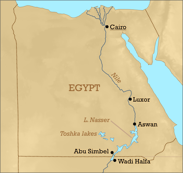
This image was created by Mark Dingemanse and released under the Creative Commons Attribution 2.5 license. The image and any derivatives should be attributed to its creator (Mark Dingemanse) and/or to his agency (vormdicht); if you choose the latter, please provide a link to www.vormdicht.nl. Feel free to notify me when you're using one of my images outside of the Wikimedia projects; that way, I'll be able to let you know when I release an updated version.
ဖိုင်မှတ်တမ်း
ဖိုင်ကို ယင်းနေ့စွဲ အတိုင်း မြင်နိုင်ရန် နေ့စွဲ/အချိန် တစ်ခုခုပေါ်တွင် ကလစ်နှိပ်ပါ။
| နေ့စွဲ/အချိန် | နမူနာပုံငယ် | မှတ်တမ်း ဒိုင်မန်းရှင်းများ | အသုံးပြုသူ | မှတ်ချက် | |
|---|---|---|---|---|---|
| ကာလပေါ် | ၂၂:၅၅၊ ၉ ဇန်နဝါရီ ၂၀၀၅ | | ၆၀၀ × ၅၇၀ (၁၁၃ KB) | M. Dingemanse | another update |
| ၂၂:၂၅၊ ၉ ဇန်နဝါရီ ၂၀၀၅ |  | ၈၀၀ × ၈၁၀ (၁၇၈ KB) | M. Dingemanse | oops, Toska/Toshka typo | |
| ၂၂:၁၉၊ ၉ ဇန်နဝါရီ ၂၀၀၅ |  | ၈၀၀ × ၈၁၀ (၁၇၈ KB) | M. Dingemanse | major improvements | |
| ၂၂:၃၁၊ ၂၈ ဒီဇင်ဘာ ၂၀၀၄ |  | ၆၀၀ × ၇၁၈ (၁၅၅ KB) | M. Dingemanse | typo | |
| ၁၂:၁၉၊ ၂၈ ဒီဇင်ဘာ ၂၀၀၄ |  | ၆၀၀ × ၇၁၈ (၁၅၅ KB) | M. Dingemanse | layout fix | |
| ၁၂:၀၅၊ ၂၈ ဒီဇင်ဘာ ၂၀၀၄ |  | ၆၀၀ × ၇၁၈ (၁၅၆ KB) | M. Dingemanse | bigger version | |
| ၁၂:၀၃၊ ၂၈ ဒီဇင်ဘာ ၂၀၀၄ |  | ၄၀၀ × ၄၇၉ (၉၀ KB) | M. Dingemanse | Lake Nasser location, created by Mark Dingemanse Dec 28, 2004. {{cc-by-2.0 |
ဖိုင်သုံးစွဲမှု
အောက်ပါ စာမျက်နှာ သည် ဤဖိုင်ကို အသုံးပြုထားသည်:
ဂလိုဘယ် ဖိုင်သုံးစွဲမှု
အောက်ပါ အခြားဝီကီများတွင် ဤဖိုင်ကို အသုံးပြုထားသည်-
- ar.wikipedia.org တွင် အသုံးပြုမှု
- azb.wikipedia.org တွင် အသုံးပြုမှု
- az.wikipedia.org တွင် အသုံးပြုမှု
- be.wikipedia.org တွင် အသုံးပြုမှု
- ca.wikipedia.org တွင် အသုံးပြုမှု
- cs.wikipedia.org တွင် အသုံးပြုမှု
- da.wikipedia.org တွင် အသုံးပြုမှု
- de.wikipedia.org တွင် အသုံးပြုမှု
- en.wikipedia.org တွင် အသုံးပြုမှု
- eo.wikipedia.org တွင် အသုံးပြုမှု
- es.wikipedia.org တွင် အသုံးပြုမှု
- eu.wikipedia.org တွင် အသုံးပြုမှု
- fa.wikipedia.org တွင် အသုံးပြုမှု
- fi.wikipedia.org တွင် အသုံးပြုမှု
- fr.wikipedia.org တွင် အသုံးပြုမှု
- fr.wikinews.org တွင် အသုံးပြုမှု
- gl.wikipedia.org တွင် အသုံးပြုမှု
- hi.wikipedia.org တွင် အသုံးပြုမှု
- hr.wikipedia.org တွင် အသုံးပြုမှု
- hy.wikipedia.org တွင် အသုံးပြုမှု
- ia.wikipedia.org တွင် အသုံးပြုမှု
- id.wikipedia.org တွင် အသုံးပြုမှု
- incubator.wikimedia.org တွင် အသုံးပြုမှု
- it.wikivoyage.org တွင် အသုံးပြုမှု
- ja.wikipedia.org တွင် အသုံးပြုမှု
- jv.wikipedia.org တွင် အသုံးပြုမှု
- mk.wikipedia.org တွင် အသုံးပြုမှု
- ml.wikipedia.org တွင် အသုံးပြုမှု
- ms.wikipedia.org တွင် အသုံးပြုမှု
- nl.wikipedia.org တွင် အသုံးပြုမှု
- nn.wikipedia.org တွင် အသုံးပြုမှု
- no.wikipedia.org တွင် အသုံးပြုမှု
- oc.wikipedia.org တွင် အသုံးပြုမှု
- os.wikipedia.org တွင် အသုံးပြုမှု
- pl.wikipedia.org တွင် အသုံးပြုမှု
ဤဖိုင်ကို အခြားနေရာများတွင် အသုံးပြုထားမှုများအား ကြည့်ရှုရန်။