ဖိုင်:LocationNorthKorea.png
သည်ထက်ကြီးသော resolution မရှိပါ.
LocationNorthKorea.png (၂၅၀ × ၁၁၅ pixels, ဖိုင်အရွယ်အစား - ၆ KB, MIME အမျိုးအစား image/png)
| ဤဖိုင်သည် Wikimedia Commons မှဖြစ်ပြီး အခြားပရောဂျက်များတွင် သုံးကောင်းသုံးလိမ့်မည်။ ယင်း၏ ဖိုင်အကြောင်းစာမျက်နှာ တွင် ဖော်ပြထားချက်ကို အောက်တွင် ပြထားသည်။ Commons သည် မူပိုင်ခွင့်လွတ်လပ်သော မီဒီယာဖိုင်များ သိုလှောင်ထားရာ နေရာ ဖြစ်သည်။ သင်လည်း ပါဝင်ကူညီနိုင်ပါသည်။ |

|
File:Locator map of North Korea.svg is a vector version of this file. It should be used in place of this PNG file when not inferior.
File:LocationNorthKorea.png → File:Locator map of North Korea.svg
For more information, see Help:SVG. |
 |
|
|
File:LocationNorthKorea.svg is a vector version of this file. It should be used in place of this PNG file when not inferior.
File:LocationNorthKorea.png → File:LocationNorthKorea.svg
For more information, see Help:SVG. |
 |
အကျဉ်းချုပ်
| ဖော်ပြချက် | |
| ရင်းမြစ် | English Wikipedia |
| စာရေးသူ | Vardion |
| အခြား ဗားရှင်းများ |
|
လိုင်စင်သတ်မှတ်ခြင်း
| |
This work has been released into the public domain by its author, Vardion, at the အင်္ဂလိပ် ဝီကီပီးဒီးယား project. This applies worldwide. In case this is not legally possible: |
ဖိုင်မှတ်တမ်း
ဖိုင်ကို ယင်းနေ့စွဲ အတိုင်း မြင်နိုင်ရန် နေ့စွဲ/အချိန် တစ်ခုခုပေါ်တွင် ကလစ်နှိပ်ပါ။
| နေ့စွဲ/အချိန် | နမူနာပုံငယ် | မှတ်တမ်း ဒိုင်မန်းရှင်းများ | အသုံးပြုသူ | မှတ်ချက် | |
|---|---|---|---|---|---|
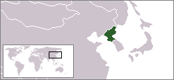
| ကာလပေါ် | ၀၂:၅၈၊ ၂၃ ဒီဇင်ဘာ ၂၀၀၄ | | ၂၅၀ × ၁၁၅ (၆ KB) | EugeneZelenko | Location map for the North Korea.<br/>Originally created for English Wikipedia by Vardion.<br/>{{PD}}<br/>Category:Country locator maps |
ဖိုင်သုံးစွဲမှု
ဤဖိုင်ကို အသုံးပြုထားသော စာမျက်နှာများမရှိပါ။
ဂလိုဘယ် ဖိုင်သုံးစွဲမှု
အောက်ပါ အခြားဝီကီများတွင် ဤဖိုင်ကို အသုံးပြုထားသည်-
- ar.wikinews.org တွင် အသုံးပြုမှု
- الرئيس الأمريكي الأسبق بيل كلينتون يلتقي رئيس كوريا الشمالية
- قالب:كوريا الشمالية
- كوريا الشمالية تنوي إطلاق قمر صناعي في هذا الشهر
- كوريا الديمقراطية تعلن إلغاء اتفاقية عدم الاعتداء مع كوريا الجنوبية
- بعد زوج عمته "كيم جونغ أون" يعدم وزير الدفاع
- كوريا الشمالية تتحدى أميركا بصاروخ "مجهول الطراز"
- كوريا الشمالية: واشنطن تدفعنا لحرب نووية
- دلائل على تورط كوريا الشمالية في هجوم "الفدية"
- كوريا الشمالية تؤكد نجاح تجربتها الصاروخية الأخيرة
- كوريا الشمالية تطلق مجموعة من الصواريخ التجريبية
- كوريا الشمالية تعلن نجاح إطلاق صاروخ عابر للقارات
- كوريا الشمالية تضع خطة لضرب غوام الأمريكية
- ري يونج: ترمب أشعل فتيل الحرب
- كوريا الشمالية تعلن أنها أصبحت دولة نووية
- كيم: زر القنبلة النووية موجود على مكتبي دائماً
- محادثات بين الكوريتين الأولى من نوعها منذ عامين
- 70 مليون إنسان يعانون من أزمات بصمت
- عقلية انتحارية: عن الحرب المرتقَبة في شمال شرق آسيا
- ast.wikipedia.org တွင် အသုံးပြုမှု
- bg.wikipedia.org တွင် အသုံးပြုမှု
- bn.wikipedia.org တွင် အသုံးပြုမှု
- bo.wikipedia.org တွင် အသုံးပြုမှု
- bpy.wikipedia.org တွင် အသုံးပြုမှု
- br.wikipedia.org တွင် အသုံးပြုမှု
- bs.wikipedia.org တွင် အသုံးပြုမှု
- cbk-zam.wikipedia.org တွင် အသုံးပြုမှု
- csb.wikipedia.org တွင် အသုံးပြုမှု
- de.wikinews.org တွင် အသုံးပြုမှု
- de.wikivoyage.org တွင် အသုံးပြုမှု
- de.wiktionary.org တွင် အသုံးပြုမှု
- dsb.wikipedia.org တွင် အသုံးပြုမှု
- dz.wikipedia.org တွင် အသုံးပြုမှု
- el.wiktionary.org တွင် အသုံးပြုမှု
- en.wikipedia.org တွင် အသုံးပြုမှု
- en.wikinews.org တွင် အသုံးပြုမှု
- en.wikivoyage.org တွင် အသုံးပြုမှု
- en.wiktionary.org တွင် အသုံးပြုမှု
- eu.wiktionary.org တွင် အသုံးပြုမှု
- fi.wikinews.org တွင် အသုံးပြုမှု
- frp.wikipedia.org တွင် အသုံးပြုမှု
ဤဖိုင်ကို အခြားနေရာများတွင် အသုံးပြုထားမှုများအား ကြည့်ရှုရန်။