ဖိုင်:Location Algeria AU Africa.svg

Size of this PNG preview of this SVG file: ၆၄၆ × ၆၀၀ ပစ်ဇယ်. အခြား ပုံရိပ်ပြတ်သားမှု: ၂၅၈ × ၂၄၀ ပစ်ဇယ် | ၅၁၇ × ၄၈၀ ပစ်ဇယ် | ၈၂၇ × ၇၆၈ ပစ်ဇယ် | ၁၁၀၃ × ၁၀၂၄ ပစ်ဇယ် | ၂၂၀၆ × ၂၀၄၈ ပစ်ဇယ် | ၁၄၀၀ × ၁၃၀၀ ပစ်ဇယ်။
မူရင်းဖိုင် (SVG ဖိုင်, ၁၄၀၀ × ၁၃၀၀ pixels ကို အကြံပြုသည်, ဖိုင်အရွယ်အစား - ၂.၁၇ MB)
| ဤဖိုင်သည် Wikimedia Commons မှဖြစ်ပြီး အခြားပရောဂျက်များတွင် သုံးကောင်းသုံးလိမ့်မည်။ ယင်း၏ ဖိုင်အကြောင်းစာမျက်နှာ တွင် ဖော်ပြထားချက်ကို အောက်တွင် ပြထားသည်။ Commons သည် မူပိုင်ခွင့်လွတ်လပ်သော မီဒီယာဖိုင်များ သိုလှောင်ထားရာ နေရာ ဖြစ်သည်။ သင်လည်း ပါဝင်ကူညီနိုင်ပါသည်။ |
အကျဉ်းချုပ်
| ဖော်ပြချက် |
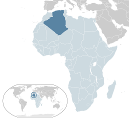
العربية: خريطة الجزائر
English: Map of Algeria
Español: Mapa de Algeria |
| ရက်စွဲ | |
| ရင်းမြစ် | ကိုယ်ပိုင်ဖန်တီးမှု |
| စာရေးသူ | Alvaro1984 18 |
လိုင်စင်သတ်မှတ်ခြင်း
| I, the copyright holder of this work, release this work into the public domain. This applies worldwide. In some countries this may not be legally possible; if so: အကျွန်ုပ်သည် ဤဖန်တီးမှုလက်ရာကို ဥပဒေအရလိုအပ်ခြင်းမရှိသည့် မည်သည့်အခြေအနေမျိုးတွက်မဆို၊ မည်သို့သော ရည်ရွယ်ချက်အတွက်မဆို ၎င်းကို မည်သူမဆို အသုံးပြုပိုင်ခွင့်အား ပေးအပ်သည်။ |
ဖိုင်မှတ်တမ်း
ဖိုင်ကို ယင်းနေ့စွဲ အတိုင်း မြင်နိုင်ရန် နေ့စွဲ/အချိန် တစ်ခုခုပေါ်တွင် ကလစ်နှိပ်ပါ။
| နေ့စွဲ/အချိန် | နမူနာပုံငယ် | မှတ်တမ်း ဒိုင်မန်းရှင်းများ | အသုံးပြုသူ | မှတ်ချက် | |
|---|---|---|---|---|---|
| ကာလပေါ် | ၀၃:၀၅၊ ၁ ဖေဖော်ဝါရီ ၂၀၁၇ | | ၁၄၀၀ × ၁၃၀၀ (၂.၁၇ MB) | BedrockPerson | Adding Morocco. |
| ၀၃:၀၅၊ ၁ ဖေဖော်ဝါရီ ၂၀၁၇ |  | ၁၄၀၀ × ၁၃၀၀ (၂.၁၇ MB) | BedrockPerson | Adding Morocco. | |
| ၁၃:၁၆၊ ၁၉ ဩဂုတ် ၂၀၁၁ |  | ၁၄၀၀ × ၁၃၀၀ (၂.၁၇ MB) | Derfel73 | Added South Sudan | |
| ၁၄:၅၃၊ ၁၈ မတ် ၂၀၁၁ |  | ၁၄၀၀ × ၁၃၀၀ (၂.၁၇ MB) | Даматрий | Reverted to version as of 14:27, 28 July 2009 Morocco is not in AU | |
| ၁၆:၀၄၊ ၁၆ ဒီဇင်ဘာ ၂၀၀၉ |  | ၁၄၀၀ × ၁၃၀၀ (၂.၁၇ MB) | Olos88 | Ujednoznacznienie koloru Maroka | |
| ၁၄:၂၇၊ ၂၈ ဇူလိုင် ၂၀၀၉ |  | ၁၄၀၀ × ၁၃၀၀ (၂.၁၇ MB) | Alvaro1984 18 | {{Information |Description={{en|1=Map of Argelia}} {{es|1=Mapa de Argelia}} |Source=trabajo propio (own work) |Author=Alvaro1984 18 |Date=30/07/2009 |Permission= |other_versions= }} Category:Location maps of Africa [[Category:A |
ဖိုင်သုံးစွဲမှု
အောက်ပါ စာမျက်နှာ သည် ဤဖိုင်ကို အသုံးပြုထားသည်:
ဂလိုဘယ် ဖိုင်သုံးစွဲမှု
အောက်ပါ အခြားဝီကီများတွင် ဤဖိုင်ကို အသုံးပြုထားသည်-
- ady.wikipedia.org တွင် အသုံးပြုမှု
- af.wikipedia.org တွင် အသုံးပြုမှု
- ar.wikipedia.org တွင် အသုံးပြုမှု
- az.wikipedia.org တွင် အသုံးပြုမှု
- ba.wikipedia.org တွင် အသုံးပြုမှု
- be.wikipedia.org တွင် အသုံးပြုမှု
- bg.wikipedia.org တွင် အသုံးပြုမှု
- bn.wikipedia.org တွင် အသုံးပြုမှု
- ca.wikipedia.org တွင် အသုံးပြုမှု
- chr.wikipedia.org တွင် အသုံးပြုမှု
- el.wikipedia.org တွင် အသုံးပြုမှု
- en.wikipedia.org တွင် အသုံးပြုမှု
- es.wikipedia.org တွင် အသုံးပြုမှု
- fa.wikipedia.org တွင် အသုံးပြုမှု
- fi.wikipedia.org တွင် အသုံးပြုမှု
- fr.wikipedia.org တွင် အသုံးပြုမှု
- gu.wikipedia.org တွင် အသုံးပြုမှု
- ha.wikipedia.org တွင် အသုံးပြုမှု
- hi.wikipedia.org တွင် အသုံးပြုမှု
- hu.wikipedia.org တွင် အသုံးပြုမှု
- hy.wikipedia.org တွင် အသုံးပြုမှု
- id.wikipedia.org တွင် အသုံးပြုမှု
- ilo.wikipedia.org တွင် အသုံးပြုမှု
- incubator.wikimedia.org တွင် အသုံးပြုမှု
- inh.wikipedia.org တွင် အသုံးပြုမှု
- it.wikipedia.org တွင် အသုံးပြုမှု
- ja.wikipedia.org တွင် အသုံးပြုမှု
- kk.wikipedia.org တွင် အသုံးပြုမှု
- km.wikipedia.org တွင် အသုံးပြုမှု
- lb.wikipedia.org တွင် အသုံးပြုမှု
- lez.wikipedia.org တွင် အသုံးပြုမှု
- lv.wikipedia.org တွင် အသုံးပြုမှု
- mr.wikipedia.org တွင် အသုံးပြုမှု
- ms.wiktionary.org တွင် အသုံးပြုမှု
- mt.wikipedia.org တွင် အသုံးပြုမှု
- mzn.wikipedia.org တွင် အသုံးပြုမှု
ဤဖိုင်ကို အခြားနေရာများတွင် အသုံးပြုထားမှုများအား ကြည့်ရှုရန်။