ဖိုင်:Madagascar physical map.svg

Size of this PNG preview of this SVG file: ၃၃၀ × ၆၀၀ ပစ်ဇယ်. အခြား ပုံရိပ်ပြတ်သားမှု: ၁၃၂ × ၂၄၀ ပစ်ဇယ် | ၂၆၄ × ၄၈၀ ပစ်ဇယ် | ၄၂၂ × ၇၆၈ ပစ်ဇယ် | ၅၆၃ × ၁၀၂၄ ပစ်ဇယ် | ၁၁၂၇ × ၂၀၄၈ ပစ်ဇယ် | ၄၂၆ × ၇၇၄ ပစ်ဇယ်။
မူရင်းဖိုင် (SVG ဖိုင်, ၄၂၆ × ၇၇၄ pixels ကို အကြံပြုသည်, ဖိုင်အရွယ်အစား - ၂.၂ MB)
| ဤဖိုင်သည် Wikimedia Commons မှဖြစ်ပြီး အခြားပရောဂျက်များတွင် သုံးကောင်းသုံးလိမ့်မည်။ ယင်း၏ ဖိုင်အကြောင်းစာမျက်နှာ တွင် ဖော်ပြထားချက်ကို အောက်တွင် ပြထားသည်။ Commons သည် မူပိုင်ခွင့်လွတ်လပ်သော မီဒီယာဖိုင်များ သိုလှောင်ထားရာ နေရာ ဖြစ်သည်။ သင်လည်း ပါဝင်ကူညီနိုင်ပါသည်။ |
အကျဉ်းချုပ်
| ဖော်ပြချက် |
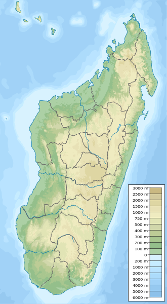
English: Physical map of Madagascar, parameters equal to Madagascar location map.svg. |
| ရက်စွဲ | |
| ရင်းမြစ် | ကိုယ်ပိုင်ဖန်တီးမှု |
| စာရေးသူ | Urutseg |
| SVG genesis | ဤ SVG ၏ ကုဒ်သည် ခိုင်လုံသည်။ This locator map was created with Adobe Illustrator, and with Inkscape. |
လိုင်စင်သတ်မှတ်ခြင်း
| I, the copyright holder of this work, release this work into the public domain. This applies worldwide. In some countries this may not be legally possible; if so: အကျွန်ုပ်သည် ဤဖန်တီးမှုလက်ရာကို ဥပဒေအရလိုအပ်ခြင်းမရှိသည့် မည်သည့်အခြေအနေမျိုးတွက်မဆို၊ မည်သို့သော ရည်ရွယ်ချက်အတွက်မဆို ၎င်းကို မည်သူမဆို အသုံးပြုပိုင်ခွင့်အား ပေးအပ်သည်။ |
ဖိုင်မှတ်တမ်း
ဖိုင်ကို ယင်းနေ့စွဲ အတိုင်း မြင်နိုင်ရန် နေ့စွဲ/အချိန် တစ်ခုခုပေါ်တွင် ကလစ်နှိပ်ပါ။
| နေ့စွဲ/အချိန် | နမူနာပုံငယ် | မှတ်တမ်း ဒိုင်မန်းရှင်းများ | အသုံးပြုသူ | မှတ်ချက် | |
|---|---|---|---|---|---|
| ကာလပေါ် | ၂၃:၀၉၊ ၁၂ မေ ၂၀၂၃ | | ၄၂၆ × ၇၇၄ (၂.၂ MB) | GrandEscogriffe | adding two region borders: Atsinanana/Analanjirofo and Vatovavy-Fitovinany |
| ၁၉:၀၂၊ ၁၁ အောက်တိုဘာ ၂၀၁၃ |  | ၄၂၆ × ၇၇၄ (၂.၁၇ MB) | NordNordWest | upd | |
| ၁၉:၂၆၊ ၁၃ ဖေဖော်ဝါရီ ၂၀၁၁ |  | ၄၂၆ × ၇၇၄ (၂.၇၆ MB) | Urutseg | {{Information |Description ={{en|1=Physical map of Madagascar, parameters equal to File:Madagascar location map.svg.}} |Source ={{own}} |Author =Urutseg |Date =2011-02-13 |Permission = |other_version |
ဖိုင်သုံးစွဲမှု
အောက်ပါ 8 စာမျက်နှာများ သည် ဤဖိုင်ကို အသုံးပြုထားသည်:
ဂလိုဘယ် ဖိုင်သုံးစွဲမှု
အောက်ပါ အခြားဝီကီများတွင် ဤဖိုင်ကို အသုံးပြုထားသည်-
- ar.wikipedia.org တွင် အသုံးပြုမှု
- arz.wikipedia.org တွင် အသုံးပြုမှု
- ast.wikipedia.org တွင် အသုံးပြုမှု
- azb.wikipedia.org တွင် အသုံးပြုမှု
- az.wikipedia.org တွင် အသုံးပြုမှု
- ba.wikipedia.org တွင် အသုံးပြုမှု
- be.wikipedia.org တွင် အသုံးပြုမှု
- bg.wikipedia.org တွင် အသုံးပြုမှု
- Антананариву
- Шаблон:ПК Мадагаскар
- Анцирабе
- Амбатулямпи
- Бетафо
- Анджома Рамартина
- Ранумафана (окръг Ифанадиана)
- Васиана
- Анказомириотра
- Инанантона
- Мандото
- Мандрицара (окръг Бетафо)
- Махаиза
- Тритрива
- Фидирана
- Соавина (окръг Бетафо)
- Амбалярану
- Белязау
- Амбухинапечака
- Анджануманеляча
- Миаринариву Бемулюлю
- Амбовомбе
- bn.wikipedia.org တွင် အသုံးပြုမှု
- bs.wikipedia.org တွင် အသုံးပြုမှု
- ca.wikipedia.org တွင် အသုံးပြုမှု
- ceb.wikipedia.org တွင် အသုံးပြုမှု
ဤဖိုင်ကို အခြားနေရာများတွင် အသုံးပြုထားမှုများအား ကြည့်ရှုရန်။