ဖိုင်:Maldives.visibleearth.nasa.jpg

ဤနမူနာ၏ အရွယ်အစား - ၄၆၆ × ၅၉၉ ပစ်ဇယ်။ အခြား ပုံရိပ်ပြတ်သားမှု: ၁၈၇ × ၂၄၀ ပစ်ဇယ် | ၃၇၃ × ၄၈၀ ပစ်ဇယ် | ၅၉၇ × ၇၆၈ ပစ်ဇယ် | ၇၉၆ × ၁၀၂၄ ပစ်ဇယ် | ၁၄၀၀ × ၁၈၀၀ ပစ်ဇယ်။
မူရင်းဖိုင် (၁၄၀၀ × ၁၈၀၀ pixels, ဖိုင်အရွယ်အစား - ၅၃၀ KB, MIME အမျိုးအစား image/jpeg)
| ဤဖိုင်သည် Wikimedia Commons မှဖြစ်ပြီး အခြားပရောဂျက်များတွင် သုံးကောင်းသုံးလိမ့်မည်။ ယင်း၏ ဖိုင်အကြောင်းစာမျက်နှာ တွင် ဖော်ပြထားချက်ကို အောက်တွင် ပြထားသည်။ Commons သည် မူပိုင်ခွင့်လွတ်လပ်သော မီဒီယာဖိုင်များ သိုလှောင်ထားရာ နေရာ ဖြစ်သည်။ သင်လည်း ပါဝင်ကူညီနိုင်ပါသည်။ |

|
This map has been uploaded by Electionworld from en.wikipedia.org to enable the |
အကျဉ်းချုပ်
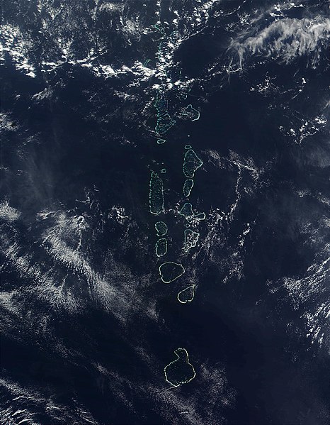
Source: http://visibleearth.nasa.gov
It should be noted that the southern most Atoll of the Maldives, Addu Atoll, is not visible on this image.
လိုင်စင်သတ်မှတ်ခြင်း
| This file is in the public domain in the United States because it was solely created by NASA. NASA copyright policy states that "NASA material is not protected by copyright unless noted". (See Template:PD-USGov, NASA copyright policy page or JPL Image Use Policy.) | ||
 |
Warnings:
|
ဖိုင်မှတ်တမ်း
ဖိုင်ကို ယင်းနေ့စွဲ အတိုင်း မြင်နိုင်ရန် နေ့စွဲ/အချိန် တစ်ခုခုပေါ်တွင် ကလစ်နှိပ်ပါ။
| နေ့စွဲ/အချိန် | နမူနာပုံငယ် | မှတ်တမ်း ဒိုင်မန်းရှင်းများ | အသုံးပြုသူ | မှတ်ချက် | |
|---|---|---|---|---|---|
| ကာလပေါ် | ၂၂:၅၂၊ ၂၇ နိုဝင်ဘာ ၂၀၀၆ | | ၁၄၀၀ × ၁၈၀၀ (၅၃၀ KB) | Electionworld | {{ew|en|Oblivious}} == Summary == '''Source:''' [http://veimages.gsfc.nasa.gov/2686/Maldives.A2002090.0525.500m.jpg http://visibleearth.nasa.gov] It should be noted that the southern most Atoll of the Maldives, Addu Atoll, is not visible on this ima |
ဖိုင်သုံးစွဲမှု
အောက်ပါ စာမျက်နှာ သည် ဤဖိုင်ကို အသုံးပြုထားသည်:
ဂလိုဘယ် ဖိုင်သုံးစွဲမှု
အောက်ပါ အခြားဝီကီများတွင် ဤဖိုင်ကို အသုံးပြုထားသည်-
- af.wikipedia.org တွင် အသုံးပြုမှု
- ar.wikipedia.org တွင် အသုံးပြုမှု
- en.wikipedia.org တွင် အသုံးပြုမှု
- gl.wikipedia.org တွင် အသုံးပြုမှု
- hi.wikipedia.org တွင် အသုံးပြုမှု
- it.wikipedia.org တွင် အသုံးပြုမှု
- kn.wikipedia.org တွင် အသုံးပြုမှု
- lt.wikipedia.org တွင် အသုံးပြုမှု
- mk.wikipedia.org တွင် အသုံးပြုမှု
- ml.wikipedia.org တွင် အသုံးပြုမှု
- pl.wikipedia.org တွင် အသုံးပြုမှု
- sd.wikipedia.org တွင် အသုံးပြုမှု
- sr.wikipedia.org တွင် အသုံးပြုမှု
- ta.wikipedia.org တွင် အသုံးပြုမှု
- th.wikipedia.org တွင် အသုံးပြုမှု
- trv.wikipedia.org တွင် အသုံးပြုမှု
- tr.wikipedia.org တွင် အသုံးပြုမှု
- uk.wikipedia.org တွင် အသုံးပြုမှု
- vi.wikipedia.org တွင် အသုံးပြုမှု
- zh.wikipedia.org တွင် အသုံးပြုမှု