ဖိုင်:Map Dutch World scris.png
ဤနမူနာ၏ အရွယ်အစား - ၈၀၀ × ၃၅၁ ပစ်ဇယ်။ အခြား ပုံရိပ်ပြတ်သားမှု: ၃၂၀ × ၁၄၀ ပစ်ဇယ် | ၆၄၀ × ၂၈၁ ပစ်ဇယ် | ၁၄၂၅ × ၆၂၅ ပစ်ဇယ်။
မူရင်းဖိုင် (၁၄၂၅ × ၆၂၅ pixels, ဖိုင်အရွယ်အစား - ၆၁ KB, MIME အမျိုးအစား image/png)
| ဤဖိုင်သည် Wikimedia Commons မှဖြစ်ပြီး အခြားပရောဂျက်များတွင် သုံးကောင်းသုံးလိမ့်မည်။ ယင်း၏ ဖိုင်အကြောင်းစာမျက်နှာ တွင် ဖော်ပြထားချက်ကို အောက်တွင် ပြထားသည်။ Commons သည် မူပိုင်ခွင့်လွတ်လပ်သော မီဒီယာဖိုင်များ သိုလှောင်ထားရာ နေရာ ဖြစ်သည်။ သင်လည်း ပါဝင်ကူညီနိုင်ပါသည်။ |
အကျဉ်းချုပ်
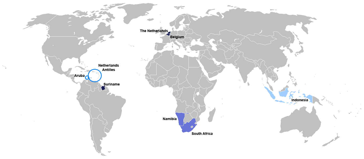
New map for Dutch-speaking world with country names. Modified version of Image:Map Dutch World nou.png
Deutsch: Legende:
- Dunkelblau: Mutter- und Mehrheitssprache
- Blau: Afrikaans (Tochtersprache)
- Hellblau: Zweit- oder nicht offizielle Sprache bzw. weiterhin vorhandene Kenntnis
English: English: Legend:
- Dark blue: native and majority language
- Blue: Afrikaans (daughter language)
- Light blue: secondary (non-official language), where some knowledge persists
Français : Français : Légende:
- Bleu foncé : langue maternelle et majoritaire
- Bleu : Afrikaans («langue fille»)
- Bleu clair : langue secondaire ou non officielle
Italiano: Italiano: Legenda:
- Blu scuro: lingua madre e maggioritaria
- Blu: Afrikaans (lingua affiliata)
- Blu chiaro: seconda lingua e/o non ufficiale, dove la sua conoscenza persiste sino ad oggi
Nederlands: Nederlands: Legenda:
- Donkerblauw: Moedertaal en belangrijkste taal
- Blauw: Afrikaans (dochtertaal)
- Lichtblauw: secundaire taal (niet-officiële taal), waar enkele kennis bestaat
Português: Português: Legenda:
- Azul escuro: língua mãe e majoritária
- Azul: Africâner (língua descendente)
- Azul claro: língua secundária (não oficial), onde ainda persiste algum conhecimento
Română: Română: Legendă:
- Albastru închis: limbă naţională
- Albastru: Afrikaans
- Albastru deschis: limbă secundară, neoficială
Español: Español : Leyenda:
- Azul obscuro : lengua materna y mayoritaria
- Azul : Afrikaans (lengua «hija»)
- Azul claro : lengua secundaria (no oficial), donde aún persiste conocimiento de ella.

|
This file has been superseded by Map of the Dutch World.svg. It is recommended to use the other file. Please note that deleting superseded images requires consent.
|

|
File:Map of the Dutch World.svg is a vector version of this file. It should be used in place of this PNG file.
File:Map Dutch World scris.png → File:Map of the Dutch World.svg
For more information, see Help:SVG. |
 |
လိုင်စင်သတ်မှတ်ခြင်း
ကျွန်ုပ်၊ ဤလုပ်ဆောင်ချက်၏ မူပိုင်ခွင့်ပိုင်ရှင်အနေဖြင့် ဤနေရာမှ အောက်ပါလိုင်စင်အောက်တွင် ထုတ်လွှင့်ပါသည်:

|
ဤစာတမ်းကို GNU Free Documentation License, ဗားရှင်း ၁.၂ သို့မဟုတ် Free Software Foundation မှ ဖြန့်ချီထားသော မည်သည့်ယခင်ဗားရှင်းတစ်ခုခုအောက်တွင် Invariant Sections, Front-Cover Texts နှင့် Back-Cover Texts များမပါဝင်ဘဲ ကူးယူခြင်း၊ ဖြန့်ချီခြင်း နှင့်/သို့မဟုတ် ပြင်ဆင်ပြောင်းလဲနိုင်ရန် ခွင့်ပြုသည်။ လိုင်စင်မူပွားကို GNU Free Documentation License ခေါင်းစဉ်အောက်တွင် ထည့်သွင်းထားသည်။ |
| ဤဖိုင်ကို Creative Commons Attribution-Share Alike 3.0 Unported လိုင်စင်ဖြင့် သတ်မှတ်ထားသည်။ | ||
| ||
| This licensing tag was added to this file as part of the GFDL licensing update. |
ဖိုင်မှတ်တမ်း
ဖိုင်ကို ယင်းနေ့စွဲ အတိုင်း မြင်နိုင်ရန် နေ့စွဲ/အချိန် တစ်ခုခုပေါ်တွင် ကလစ်နှိပ်ပါ။
| နေ့စွဲ/အချိန် | နမူနာပုံငယ် | မှတ်တမ်း ဒိုင်မန်းရှင်းများ | အသုံးပြုသူ | မှတ်ချက် | |
|---|---|---|---|---|---|
| ကာလပေါ် | ၁၉:၀၆၊ ၇ ဇူလိုင် ၂၀၁၀ | | ၁၄၂၅ × ၆၂၅ (၆၁ KB) | Hooiwind | deeper colours so it is easier to see the countries on a smaller scale + removal of "minority dots", geographically confusing and pretty arbitrary. |
| ၁၇:၄၆၊ ၁၆ ဖေဖော်ဝါရီ ၂၀၀၇ |  | ၁၄၂၅ × ၆၂၅ (၃၄ KB) | Danutz | New map for Dutch-speaking world with country names. Modified version of Image:Map Dutch World nou.png English: Legend: *Dark blue: native language *Blue: administrative language *Light blue: secondary, non-official language *Green square: minori |
ဖိုင်သုံးစွဲမှု
ဤဖိုင်ကို အသုံးပြုထားသော စာမျက်နှာများမရှိပါ။
ဂလိုဘယ် ဖိုင်သုံးစွဲမှု
အောက်ပါ အခြားဝီကီများတွင် ဤဖိုင်ကို အသုံးပြုထားသည်-
- jv.wikipedia.org တွင် အသုံးပြုမှု
- nl.wikibooks.org တွင် အသုံးပြုမှု
- sat.wikipedia.org တွင် အသုံးပြုမှု