ဖိုင်:Myanmar civil war.svg

မူရင်းဖိုင် (SVG ဖိုင်, ၁၂၂၈ × ၂၀၀၃ pixels ကို အကြံပြုသည်, ဖိုင်အရွယ်အစား - ၁.၃ MB)
| ဤဖိုင်သည် Wikimedia Commons မှဖြစ်ပြီး အခြားပရောဂျက်များတွင် သုံးကောင်းသုံးလိမ့်မည်။ ယင်း၏ ဖိုင်အကြောင်းစာမျက်နှာ တွင် ဖော်ပြထားချက်ကို အောက်တွင် ပြထားသည်။ Commons သည် မူပိုင်ခွင့်လွတ်လပ်သော မီဒီယာဖိုင်များ သိုလှောင်ထားရာ နေရာ ဖြစ်သည်။ သင်လည်း ပါဝင်ကူညီနိုင်ပါသည်။ |

|
This file may be updated to reflect new information. If you wish to use a specific version of the file without new updates being mirrored, please upload the required version as a separate file. |
အကျဉ်းချုပ်
| ဖော်ပြချက် |
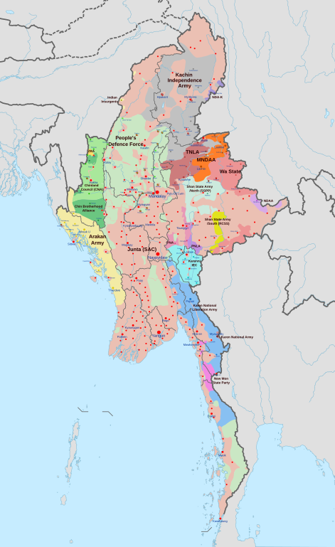
English: A map of the Myanmar civil war (2021–present)
|
| ရက်စွဲ | |
| ရင်းမြစ် | ကိုယ်ပိုင်ဖန်တီးမှု derivate of Myanmar adm location map.svg by NordNordWest. Citing @ThomasVLinge |
| စာရေးသူ | Ecrusized |
| အခြား ဗားရှင်းများ |
|

This file is translated using SVG <switch> elements. All translations are stored in the same file! Learn more.
For most Wikipedia projects, you can embed the file normally (without a To translate the text into your language, you can use the SVG Translate tool. Alternatively, you can download the file to your computer, add your translations using whatever software you're familiar with, and re-upload it with the same name. You will find help in Graphics Lab if you're not sure how to do this. |
လိုင်စင်သတ်မှတ်ခြင်း
| ဤဖိုင်ကို Creative Commons CC0 1.0 Universal Public Domain Dedication အောက်တွင် ရရှိနိုင်အောင် ဆောင်ရွက်ထားပါသည်။ | |
| The person who associated a work with this deed has dedicated the work to the public domain by waiving all of their rights to the work worldwide under copyright law, including all related and neighboring rights, to the extent allowed by law. You can copy, modify, distribute and perform the work, even for commercial purposes, all without asking permission.
|
ဖိုင်မှတ်တမ်း
ဖိုင်ကို ယင်းနေ့စွဲ အတိုင်း မြင်နိုင်ရန် နေ့စွဲ/အချိန် တစ်ခုခုပေါ်တွင် ကလစ်နှိပ်ပါ။
| နေ့စွဲ/အချိန် | နမူနာပုံငယ် | မှတ်တမ်း ဒိုင်မန်းရှင်းများ | အသုံးပြုသူ | မှတ်ချက် | |
|---|---|---|---|---|---|
| ကာလပေါ် | ၁၀:၃၂၊ ၃၀ ဧပြီ ၂၀၂၄ | | ၁၂၂၈ × ၂၀၀၃ (၁.၃ MB) | MrBLOCKiron | Continuation of yesterdays edit, check april 29 discussion. |
| ၁၆:၄၅၊ ၂၉ ဧပြီ ၂၀၂၄ |  | ၁၂၂၈ × ၂၀၀၃ (၁.၃ MB) | MrBLOCKiron | Update, check talk page for notes and sources | |
| ၁၈:၄၆၊ ၁၇ ဧပြီ ၂၀၂၄ |  | ၁၂၂၈ × ၂၀၀၃ (၁.၂၉ MB) | EmeraldRange | Updating Myawaddy area to reflect territory taken - Shwekoko to the north and Thinganyinaung to the west as per Talk on en:Myanmar civil war (2021-present) | |
| ၀၃:၀၁၊ ၁၂ ဧပြီ ၂၀၂၄ |  | ၁၂၂၈ × ၂၀၀၃ (၁.၃ MB) | PequodOnStationAtLZ | updated to reflect rebel capture of myawaddy | |
| ၂၀:၅၂၊ ၄ ဧပြီ ၂၀၂၄ |  | ၁၂၂၈ × ၂၀၀၃ (၁.၃ MB) | EmeraldRange | Updated based on Timelines , sources and new map from van Linge; see File Talk/Discusion for sources | |
| ၁၅:၃၅၊ ၂၃ မတ် ၂၀၂၄ |  | ၁၂၂၈ × ၂၀၀၃ (၁.၂၉ MB) | TheWasalpha | Capture of Rathedaung last week by AA, removed a misplaced dot in Bangladesh | |
| ၁၆:၄၇၊ ၁၇ မတ် ၂၀၂၄ |  | ၁၂၂၈ × ၂၀၀၃ (၁.၂၉ MB) | EmeraldRange | Updated with other items to March 17, see File Talk/Discussion | |
| ၀၆:၃၂၊ ၁၆ မတ် ၂၀၂၄ |  | ၁၂၂၈ × ၂၀၀၃ (၁.၂၇ MB) | Hoben7599 | See discussion for source links | |
| ၁၅:၁၂၊ ၂၁ ဖေဖော်ဝါရီ ၂၀၂၄ |  | ၁၂၂၈ × ၂၀၀၃ (၁.၂၇ MB) | EmeraldRange | Updated to include Myebon capture, Mabein capture and AA territory updates based on source from Talk:Myanmar civil war. (See discussion for source links) | |
| ၀၃:၂၅၊ ၁၆ ဖေဖော်ဝါရီ ၂၀၂၄ |  | ၁၂၂၈ × ၂၀၀၃ (၁.၂၇ MB) | EmeraldRange | fixed wrong layering for Karenni |
ဖိုင်သုံးစွဲမှု
အောက်ပါ 3 စာမျက်နှာများ သည် ဤဖိုင်ကို အသုံးပြုထားသည်:
ဂလိုဘယ် ဖိုင်သုံးစွဲမှု
အောက်ပါ အခြားဝီကီများတွင် ဤဖိုင်ကို အသုံးပြုထားသည်-
- ar.wikipedia.org တွင် အသုံးပြုမှု
- en.wikipedia.org တွင် အသုံးပြုမှု
- es.wikipedia.org တွင် အသုံးပြုမှု
- et.wikipedia.org တွင် အသုံးပြုမှု
- fa.wikipedia.org တွင် အသုံးပြုမှု
- fr.wikipedia.org တွင် အသုံးပြုမှု
- hu.wikipedia.org တွင် အသုံးပြုမှု
- it.wikipedia.org တွင် အသုံးပြုမှု
- ko.wikipedia.org တွင် အသုံးပြုမှု
- pt.wikipedia.org တွင် အသုံးပြုမှု
- ru.wikipedia.org တွင် အသုံးပြုမှု
- th.wikipedia.org တွင် အသုံးပြုမှု
- uk.wikipedia.org တွင် အသုံးပြုမှု
- zh.wikipedia.org တွင် အသုံးပြုမှု