ဖိုင်:San Felipe del Morro view across bay.jpg

မူရင်းဖိုင် (၂၁၂၉ × ၉၅၃ pixels, ဖိုင်အရွယ်အစား - ၃၇၇ KB, MIME အမျိုးအစား image/jpeg)
| ဤဖိုင်သည် Wikimedia Commons မှဖြစ်ပြီး အခြားပရောဂျက်များတွင် သုံးကောင်းသုံးလိမ့်မည်။ ယင်း၏ ဖိုင်အကြောင်းစာမျက်နှာ တွင် ဖော်ပြထားချက်ကို အောက်တွင် ပြထားသည်။ Commons သည် မူပိုင်ခွင့်လွတ်လပ်သော မီဒီယာဖိုင်များ သိုလှောင်ထားရာ နေရာ ဖြစ်သည်။ သင်လည်း ပါဝင်ကူညီနိုင်ပါသည်။ |
|
This is an image of a place or building that is listed on the National Register of Historic Places in the United States of America. Its reference number is 66000930. |
အကျဉ်းချုပ်
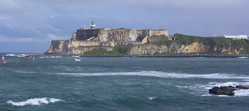
| ဖော်ပြချက် | View of San Felipe del Morro from across San Juan bay. |
| ရက်စွဲ | |
| ရင်းမြစ် | English Wikipedia (http://en.wikipedia.org/wiki/Image:San_Felipe_del_Morro_view_across_bay.jpg) |
| စာရေးသူ | http://en.wikipedia.org/wiki/User:Jmoliver |
| ခွင့်ပြုချက် (ဤဖိုင်ကို ပြန်လည်အသုံးပြုခြင်း) |
Permission is granted to copy, distribute and/or modify this document under the terms of the GNU Free Documentation License, Version 1.2 or any later version published by the Free Software Foundation; with no Invariant Sections, no Front-Cover Texts, and no Back-Cover Texts. Subject to disclaimers. |
| Object location | | View this and other nearby images on: OpenStreetMap |
|---|
လိုင်စင်သတ်မှတ်ခြင်း
| ဤဖိုင်ကို Creative Commons Attribution-Share Alike 3.0 Unported လိုင်စင်ဖြင့် သတ်မှတ်ထားသည်။ Subject to disclaimers. | ||
| ||
| This licensing tag was added to this file as part of the GFDL licensing update. |

|
ဤစာတမ်းကို GNU Free Documentation License, ဗားရှင်း ၁.၂ သို့မဟုတ် Free Software Foundation မှ ဖြန့်ချီထားသော မည်သည့်ယခင်ဗားရှင်းတစ်ခုခုအောက်တွင် Invariant Sections, Front-Cover Texts နှင့် Back-Cover Texts များမပါဝင်ဘဲ ကူးယူခြင်း၊ ဖြန့်ချီခြင်း နှင့်/သို့မဟုတ် ပြင်ဆင်ပြောင်းလဲနိုင်ရန် ခွင့်ပြုသည်။ လိုင်စင်မူပွားကို GNU Free Documentation License ခေါင်းစဉ်အောက်တွင် ထည့်သွင်းထားသည်။ Subject to disclaimers. |
ဖိုင်မှတ်တမ်း
ဖိုင်ကို ယင်းနေ့စွဲ အတိုင်း မြင်နိုင်ရန် နေ့စွဲ/အချိန် တစ်ခုခုပေါ်တွင် ကလစ်နှိပ်ပါ။
| နေ့စွဲ/အချိန် | နမူနာပုံငယ် | မှတ်တမ်း ဒိုင်မန်းရှင်းများ | အသုံးပြုသူ | မှတ်ချက် | |
|---|---|---|---|---|---|
| ကာလပေါ် | ၁၈:၄၅၊ ၃၀ ဒီဇင်ဘာ ၂၀၀၆ | | ၂၁၂၉ × ၉၅၃ (၃၇၇ KB) | MSchnitzler2000 | {{Information |Description=view across the bay of San Felipe del Morro in Puerto Rico |Source=English Wikipedia (http://en.wikipedia.org/wiki/Image:San_Felipe_del_Morro_view_across_bay.jpg) |Date=2004-12-24 |Author=http://en.wikipedia.org/wiki/User:Jmoliv |
ဖိုင်သုံးစွဲမှု
အောက်ပါ စာမျက်နှာ သည် ဤဖိုင်ကို အသုံးပြုထားသည်:
ဂလိုဘယ် ဖိုင်သုံးစွဲမှု
အောက်ပါ အခြားဝီကီများတွင် ဤဖိုင်ကို အသုံးပြုထားသည်-
- ar.wikipedia.org တွင် အသုံးပြုမှု
- arz.wikipedia.org တွင် အသုံးပြုမှု
- ca.wikipedia.org တွင် အသုံးပြုမှု
- ceb.wikipedia.org တွင် အသုံးပြုမှု
- de.wikipedia.org တွင် အသုံးပြုမှု
- de.wikivoyage.org တွင် အသုံးပြုမှု
- en.wikipedia.org တွင် အသုံးပြုမှု
- eo.wikipedia.org တွင် အသုံးပြုမှု
- es.wikipedia.org တွင် အသုံးပြုမှု
- fr.wikipedia.org တွင် အသုံးပြုမှု
- gl.wikipedia.org တွင် အသုံးပြုမှု
- gn.wikipedia.org တွင် အသုံးပြုမှု
- hi.wikipedia.org တွင် အသုံးပြုမှု
- hu.wikipedia.org တွင် အသုံးပြုမှု
- hy.wikipedia.org တွင် အသုံးပြုမှု
- ia.wikipedia.org တွင် အသုံးပြုမှု
- it.wikipedia.org တွင် အသုံးပြုမှု
- ja.wikipedia.org တွင် အသုံးပြုမှု
- ka.wikipedia.org တွင် အသုံးပြုမှု
- kk.wikipedia.org တွင် အသုံးပြုမှု
- ml.wikipedia.org တွင် အသုံးပြုမှု
- nl.wikipedia.org တွင် အသုံးပြုမှု
- pl.wikipedia.org တွင် အသုံးပြုမှု
- pt.wikipedia.org တွင် အသုံးပြုမှု
- ru.wikipedia.org တွင် အသုံးပြုမှု
- ta.wikipedia.org တွင် အသုံးပြုမှု
- uk.wikipedia.org တွင် အသုံးပြုမှု
ဤဖိုင်ကို အခြားနေရာများတွင် အသုံးပြုထားမှုများအား ကြည့်ရှုရန်။