ဖိုင်:San Francisco Bay Bridges map en.svg

Size of this PNG preview of this SVG file: ၂၇၀ × ၃၃၀ ပစ်ဇယ်. အခြား ပုံရိပ်ပြတ်သားမှု: ၁၉၆ × ၂၄၀ ပစ်ဇယ် | ၃၉၃ × ၄၈၀ ပစ်ဇယ် | ၆၂၈ × ၇၆၈ ပစ်ဇယ် | ၈၃၈ × ၁၀၂၄ ပစ်ဇယ် | ၁၆၇၆ × ၂၀၄၈ ပစ်ဇယ်။
မူရင်းဖိုင် (SVG ဖိုင်, ၂၇၀ × ၃၃၀ pixels ကို အကြံပြုသည်, ဖိုင်အရွယ်အစား - ၃၂၁ KB)
| ဤဖိုင်သည် Wikimedia Commons မှဖြစ်ပြီး အခြားပရောဂျက်များတွင် သုံးကောင်းသုံးလိမ့်မည်။ ယင်း၏ ဖိုင်အကြောင်းစာမျက်နှာ တွင် ဖော်ပြထားချက်ကို အောက်တွင် ပြထားသည်။ Commons သည် မူပိုင်ခွင့်လွတ်လပ်သော မီဒီယာဖိုင်များ သိုလှောင်ထားရာ နေရာ ဖြစ်သည်။ သင်လည်း ပါဝင်ကူညီနိုင်ပါသည်။ |
အကျဉ်းချုပ်
| ဖော်ပြချက် |
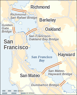
English: Map of the bridges of San Francisco Bay — in the San Francisco Bay Area, California.
|
| ရက်စွဲ | |
| ရင်းမြစ် |
ကိုယ်ပိုင်ဖန်တီးမှု This W3C-unspecified vector image was created with Inkscape . |
| စာရေးသူ | Alexrk |
| အခြား ဗားရှင်းများ | Derivative works of this file: San Francisco Bay Bridges map ar.pngDerivative works of this file: San Francisco Bay Bridges map ar.svg |

|
This map has been made or improved in the German Kartenwerkstatt (Map Lab). You can propose maps to improve as well.
|

|
This SVG file contains embedded text that can be translated into your language, using any capable SVG editor, text editor or the SVG Translate tool. For more information see: About translating SVG files. |
လိုင်စင်သတ်မှတ်ခြင်း
ကျွန်ုပ်၊ ဤလုပ်ဆောင်ချက်၏ မူပိုင်ခွင့်ပိုင်ရှင်အနေဖြင့် ဤနေရာမှ အောက်ပါလိုင်စင်အောက်တွင် ထုတ်လွှင့်ပါသည်:
ဤဖိုင်ကို Creative Commons Attribution-Share Alike 3.0 Unported လိုင်စင်ဖြင့် သတ်မှတ်ထားသည်။
- သင်သည် လွတ်လပ်စွာ:
- မျှဝေရန် – ဖန်တီးမှုကို ကူးယူရန်၊ ဖြန့်ဖြူးရန်နှင့် ထုတ်လွှင့်ရန်
- ပြန်ရောနှောရန် – ဖန်တီးမှုကို ပြင်ဆင်ညှိနှိုင်းရန်
- အောက်ပါ အခြေအနေများတွင်:
- မှတ်ယူနိုင်ခြင်း – ပြောင်းလဲမှုများ ပြုလုပ်ခဲ့ပါက ဖန်တီးသူ သို့မဟုတ် လိုင်စင်ရှိသူမှ သတ်မှတ်သော အမျိုးအစားကို လိုက်နာရမည် (ဆိုလိုသည်မှာ သင့်အား သို့မဟုတ် သင့်ဖန်တီးမှုတွင် အသုံးပြုခြင်းအား ထောက်ခံချက်ပေးသည်ဟု မဆိုလိုပါ)။
- ထပ်တူမျှဝေ – ဤဖန်တီးမှုအား ပြင်ဆင်ခြင်း၊ ပြောင်းလဲခြင်း သို့မဟုတ် ထပ်ဆင့် ဖန်တီးခြင်း ပြုလုပ်ပါက ရရှိလာသော ဖန်တီးမှုကို ဤဖန်တီးမှုနှင့် သို့မဟုတ် ဆင်တူသော လိုင်စင်ဖြင့်သာ ဖြန့်ချိသင့်သည်။
ဖိုင်မှတ်တမ်း
ဖိုင်ကို ယင်းနေ့စွဲ အတိုင်း မြင်နိုင်ရန် နေ့စွဲ/အချိန် တစ်ခုခုပေါ်တွင် ကလစ်နှိပ်ပါ။
| နေ့စွဲ/အချိန် | နမူနာပုံငယ် | မှတ်တမ်း ဒိုင်မန်းရှင်းများ | အသုံးပြုသူ | မှတ်ချက် | |
|---|---|---|---|---|---|
| ကာလပေါ် | ၁၄:၁၄၊ ၂၄ ဇူလိုင် ၂၀၀၈ | | ၂၇၀ × ၃၃၀ (၃၂၁ KB) | Alexrk | |
| ၁၅:၁၄၊ ၁၉ ဇူလိုင် ၂၀၀၈ |  | ၂၇၀ × ၃၃၀ (၃၂၁ KB) | Alexrk | 2 Scales: km & mi | |
| ၁၄:၀၁၊ ၁၉ ဇူလိုင် ၂၀၀၈ |  | ၂၇၀ × ၃၃၀ (၃၁၈ KB) | Alexrk | Scale, Size | |
| ၁၃:၄၉၊ ၁၉ ဇူလိုင် ၂၀၀၈ |  | ၂၈၇ × ၃၄၇ (၃၁၇ KB) | Alexrk | Revise Labels, Background | |
| ၁၃:၄၂၊ ၁၉ ဇူလိုင် ၂၀၀၈ |  | ၂၈၇ × ၃၄၇ (၃၀၆ KB) | Alexrk | Mess with fonts | |
| ၁၃:၃၃၊ ၁၉ ဇူလိုင် ၂၀၀၈ |  | ၂၈၇ × ၃၄၇ (၃၁၄ KB) | Alexrk | {{Information |Description={{en|1=Locator Map of San Francisco Bay bridges}} |Source=Own work by uploader |Author=Alexrk |Date= |Permission= |other_versions= }} {{ImageUpload|full}} |
ဖိုင်သုံးစွဲမှု
အောက်ပါ စာမျက်နှာ သည် ဤဖိုင်ကို အသုံးပြုထားသည်:
ဂလိုဘယ် ဖိုင်သုံးစွဲမှု
အောက်ပါ အခြားဝီကီများတွင် ဤဖိုင်ကို အသုံးပြုထားသည်-
- arz.wikipedia.org တွင် အသုံးပြုမှု
- ast.wikipedia.org တွင် အသုံးပြုမှု
- bcl.wikipedia.org တွင် အသုံးပြုမှု
- bg.wikipedia.org တွင် အသုံးပြုမှု
- ca.wikipedia.org တွင် အသုံးပြုမှု
- cs.wikipedia.org တွင် အသုံးပြုမှု
- de.wikipedia.org တွင် အသုံးပြုမှု
- en.wikipedia.org တွင် အသုံးပြုမှု
- es.wikipedia.org တွင် အသုံးပြုမှု
- fi.wikipedia.org တွင် အသုံးပြုမှု
- fr.wikipedia.org တွင် အသုံးပြုမှု
- ga.wikipedia.org တွင် အသုံးပြုမှု
- gu.wikipedia.org တွင် အသုံးပြုမှု
- he.wikipedia.org တွင် အသုံးပြုမှု
- is.wikipedia.org တွင် အသုံးပြုမှု
- ml.wikipedia.org တွင် အသုံးပြုမှု
- pt.wikipedia.org တွင် အသုံးပြုမှု
- sco.wikipedia.org တွင် အသုံးပြုမှု
- sl.wikipedia.org တွင် အသုံးပြုမှု
- ta.wikipedia.org တွင် အသုံးပြုမှု
- th.wikipedia.org တွင် အသုံးပြုမှု
- uk.wikipedia.org တွင် အသုံးပြုမှု
ဤဖိုင်ကို အခြားနေရာများတွင် အသုံးပြုထားမှုများအား ကြည့်ရှုရန်။