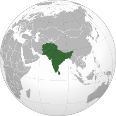
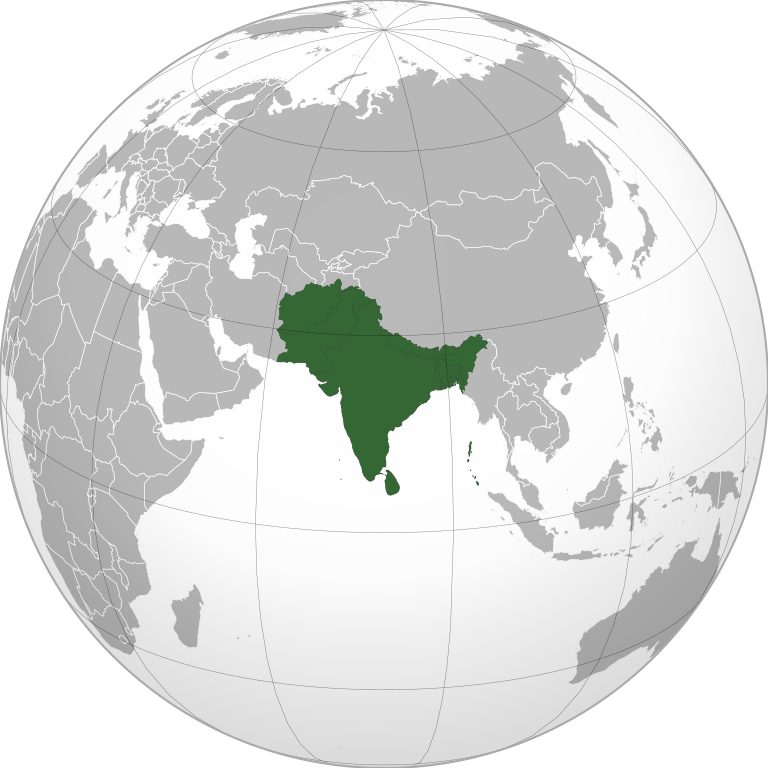
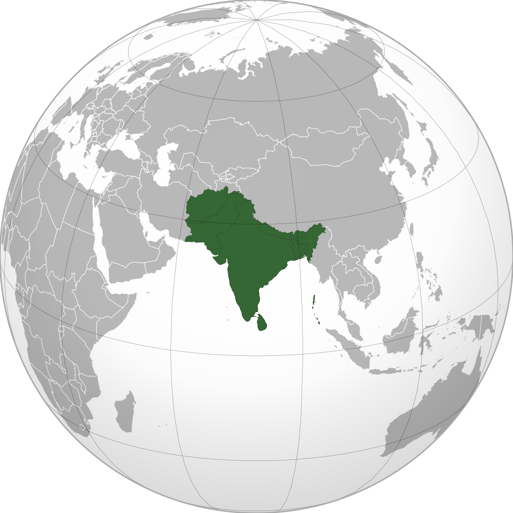
ဖိုင်:South Asia (orthographic projection) without national boundaries.svg

Size of this PNG preview of this SVG file: ၅၅၀ × ၅၅၀ ပစ်ဇယ်. အခြား ပုံရိပ်ပြတ်သားမှု: ၂၄၀ × ၂၄၀ ပစ်ဇယ် | ၄၈၀ × ၄၈၀ ပစ်ဇယ် | ၇၆၈ × ၇၆၈ ပစ်ဇယ် | ၁၀၂၄ × ၁၀၂၄ ပစ်ဇယ် | ၂၀၄၈ × ၂၀၄၈ ပစ်ဇယ်။
မူရင်းဖိုင် (SVG ဖိုင်, ၅၅၀ × ၅၅၀ pixels ကို အကြံပြုသည်, ဖိုင်အရွယ်အစား - ၂.၈ MB)
| ဤဖိုင်သည် Wikimedia Commons မှဖြစ်ပြီး အခြားပရောဂျက်များတွင် သုံးကောင်းသုံးလိမ့်မည်။ ယင်း၏ ဖိုင်အကြောင်းစာမျက်နှာ တွင် ဖော်ပြထားချက်ကို အောက်တွင် ပြထားသည်။ Commons သည် မူပိုင်ခွင့်လွတ်လပ်သော မီဒီယာဖိုင်များ သိုလှောင်ထားရာ နေရာ ဖြစ်သည်။ သင်လည်း ပါဝင်ကူညီနိုင်ပါသည်။ |
အကျဉ်းချုပ်
| ဖော်ပြချက် |
English: South Asia |
||
| ရက်စွဲ | (UTC) | ||
| ရင်းမြစ် | |||
| စာရေးသူ | user:Serg!o | ||
| အခြား ဗားရှင်းများ |
.svg) |
||
| SVG genesis | ဤ SVG ၏ ကုဒ်သည် ခိုင်လုံသည်။
|
.svg)
.svg)
.svg)
.svg)
.svg)
.svg)
.svg)
.svg)
.svg)
.svg)
.svg)
.svg)
.svg)
.svg)
.svg)
.svg)
.svg)
.svg)
.svg)
.svg)
.svg)
.svg)
.svg)
.svg)
.svg)
.svg)
.svg)
.svg)
.svg)
.svg)
.svg)
.svg)
.svg)
.svg)
.svg)
.svg)
.svg)
.svg)
.svg)
.svg)
.svg)
.svg)
.svg)
.svg)
.svg)
.svg)
.svg)
.svg)
.svg)
.svg)
.svg)
.svg)
.svg)
.svg)
.svg)
.svg)
.svg)
.svg)
.svg)
.svg)
.svg)
.svg)
.svg)
.svg)
.svg)
.svg)
.svg)
.svg)
.svg)
.svg)
.svg)
.svg)
.svg)

.svg)

.svg)

.svg)
.svg)
.svg)
.svg)
.svg)
.svg)
.svg)


.svg)
.svg)
.svg)
.svg)
.svg)
.svg)
.svg)

.svg)
.svg)
.svg)
.svg)
.svg)
.svg)
.svg)
.svg)
.svg)

.svg)
.svg)
.svg)
.svg)
.svg)
.svg)
.svg)
_without_national_boundaries.svg)
.svg)
.svg)
.svg)
.svg)
.svg)
.svg)

.svg)
.svg)
.png)
.svg)
.svg)
.svg)
.svg)

.svg)
.svg)
.svg)
.svg)
.svg)
.svg)
.svg)
.svg)
.svg)
.svg)
.svg)

.svg)
.svg)
.svg)
.svg)
.svg)
.svg)
.svg)
.svg)
.svg)

.svg)
.svg)

.svg)
.svg)
.svg)
.svg)
.svg)
.svg)
.svg)
.svg)
.svg)
.svg)
.svg)
.svg)
.svg)
.svg)
.svg)
.svg)
.svg)
.svg)
.svg)
.svg)
.svg)
.svg)
.svg)
.svg)
.svg)
.svg)
.svg)
_-_Crimea_disputed.svg)
.svg)
.svg)
.svg)
.svg)
.svg)
.svg)
.svg)
.svg)
.svg)
.svg)
.svg)
_political.svg)
.svg)
.svg)
.svg)
.svg)
_-_Crimea_disputed_-_no_borders.svg)
.svg)
.svg)
.svg)
.svg)
.svg)
.svg)
.svg)
.svg)
.svg)
.svg)
.svg)

.svg)
.svg)
.svg)

.png)
.svg)
.svg)
.svg)
.svg)
.svg)
.svg)
.svg)
.svg)
.svg)
.svg)
.svg)
.svg)
.svg)
.svg)
.svg)
.svg)
.svg)
.svg)
.svg)
.svg)
.svg)
.svg)
.svg)
.svg)
.svg)
.svg)
.svg)
.svg)
.svg)
.svg)
.svg)
.svg)
.svg)
.svg)
.png)
.svg)
.svg)
.svg)
_(orthographic_projection).png)
_without_national_boundaries.svg)
လိုင်စင်သတ်မှတ်ခြင်း
ကျွန်ုပ်၊ ဤလုပ်ဆောင်ချက်၏ မူပိုင်ခွင့်ပိုင်ရှင်အနေဖြင့် ဤနေရာမှ အောက်ပါလိုင်စင်များအောက်တွင် ထုတ်လွှင့်ပါသည်:
ဤဖိုင်ကို Creative Commons Attribution-Share Alike 3.0 Unported လိုင်စင်ဖြင့် သတ်မှတ်ထားသည်။
- သင်သည် လွတ်လပ်စွာ:
- မျှဝေရန် – ဖန်တီးမှုကို ကူးယူရန်၊ ဖြန့်ဖြူးရန်နှင့် ထုတ်လွှင့်ရန်
- ပြန်ရောနှောရန် – ဖန်တီးမှုကို ပြင်ဆင်ညှိနှိုင်းရန်
- အောက်ပါ အခြေအနေများတွင်:
- မှတ်ယူနိုင်ခြင်း – ပြောင်းလဲမှုများ ပြုလုပ်ခဲ့ပါက ဖန်တီးသူ သို့မဟုတ် လိုင်စင်ရှိသူမှ သတ်မှတ်သော အမျိုးအစားကို လိုက်နာရမည် (ဆိုလိုသည်မှာ သင့်အား သို့မဟုတ် သင့်ဖန်တီးမှုတွင် အသုံးပြုခြင်းအား ထောက်ခံချက်ပေးသည်ဟု မဆိုလိုပါ)။
- ထပ်တူမျှဝေ – ဤဖန်တီးမှုအား ပြင်ဆင်ခြင်း၊ ပြောင်းလဲခြင်း သို့မဟုတ် ထပ်ဆင့် ဖန်တီးခြင်း ပြုလုပ်ပါက ရရှိလာသော ဖန်တီးမှုကို ဤဖန်တီးမှုနှင့် သို့မဟုတ် ဆင်တူသော လိုင်စင်ဖြင့်သာ ဖြန့်ချိသင့်သည်။

|
ဤစာတမ်းကို GNU Free Documentation License, ဗားရှင်း ၁.၂ သို့မဟုတ် Free Software Foundation မှ ဖြန့်ချီထားသော မည်သည့်ယခင်ဗားရှင်းတစ်ခုခုအောက်တွင် Invariant Sections, Front-Cover Texts နှင့် Back-Cover Texts များမပါဝင်ဘဲ ကူးယူခြင်း၊ ဖြန့်ချီခြင်း နှင့်/သို့မဟုတ် ပြင်ဆင်ပြောင်းလဲနိုင်ရန် ခွင့်ပြုသည်။ လိုင်စင်မူပွားကို GNU Free Documentation License ခေါင်းစဉ်အောက်တွင် ထည့်သွင်းထားသည်။ |
|
|
ဤစာတမ်းကို GNU Free Documentation License, ဗားရှင်း ၁.၂ သို့မဟုတ် Free Software Foundation မှ ဖြန့်ချီထားသော မည်သည့်ယခင်ဗားရှင်းတစ်ခုခုအောက်တွင် Invariant Sections, Front-Cover Texts နှင့် Back-Cover Texts များမပါဝင်ဘဲ ကူးယူခြင်း၊ ဖြန့်ချီခြင်း နှင့်/သို့မဟုတ် ပြင်ဆင်ပြောင်းလဲနိုင်ရန် ခွင့်ပြုသည်။ လိုင်စင်မူပွားကို GNU Free Documentation License ခေါင်းစဉ်အောက်တွင် ထည့်သွင်းထားသည်။ |
သင်အလိုရှိရာ လိုင်စင်ကို ရွေးချယ်နိုင်ပါသည်။
The map has been created with the Generic Mapping Tools: https://www.generic-mapping-tools.org/ using one or more of these public-domain datasets for the relief:
|
|
|
ဤစာတမ်းကို GNU Free Documentation License, ဗားရှင်း ၁.၂ သို့မဟုတ် Free Software Foundation မှ ဖြန့်ချီထားသော မည်သည့်ယခင်ဗားရှင်းတစ်ခုခုအောက်တွင် Invariant Sections, Front-Cover Texts နှင့် Back-Cover Texts များမပါဝင်ဘဲ ကူးယူခြင်း၊ ဖြန့်ချီခြင်း နှင့်/သို့မဟုတ် ပြင်ဆင်ပြောင်းလဲနိုင်ရန် ခွင့်ပြုသည်။ လိုင်စင်မူပွားကို GNU Free Documentation License ခေါင်းစဉ်အောက်တွင် ထည့်သွင်းထားသည်။ |
ဖိုင်မှတ်တမ်း
ဖိုင်ကို ယင်းနေ့စွဲ အတိုင်း မြင်နိုင်ရန် နေ့စွဲ/အချိန် တစ်ခုခုပေါ်တွင် ကလစ်နှိပ်ပါ။
_without_national_boundaries.svg&dir=prev)
_without_national_boundaries.svg&offset=20200819201055)
_without_national_boundaries.svg&offset=&limit=20)
_without_national_boundaries.svg&offset=&limit=50)
_without_national_boundaries.svg&offset=&limit=100)
_without_national_boundaries.svg&offset=&limit=250)
_without_national_boundaries.svg&offset=&limit=500)
| နေ့စွဲ/အချိန် | နမူနာပုံငယ် | မှတ်တမ်း ဒိုင်မန်းရှင်းများ | အသုံးပြုသူ | မှတ်ချက် | |
|---|---|---|---|---|---|
| ကာလပေါ် | ၀၆:၁၀၊ ၁၂ နိုဝင်ဘာ ၂၀၂၂ | | ၅၅၀ × ၅၅၀ (၂.၈ MB) | Sourav Bapuli | Added Siachen Glacier as requested by {{u|King Prithviraj II}} |
| ၁၇:၅၆၊ ၁ ဇန်နဝါရီ ၂၀၂၁ |  | ၅၅၃ × ၅၅၃ (၂၁၆ KB) | Sbb1413 | Converted to Plain SVG. | |
| ၁၇:၅၂၊ ၁ ဇန်နဝါရီ ၂၀၂၁ |  | ၅၅၃ × ၅၅၃ (၂၁၆ KB) | Sbb1413 | The previous attempt failed, another attempt of correcting the errors. | |
| ၁၇:၄၈၊ ၁ ဇန်နဝါရီ ၂၀၂၁ |  | ၅၅၃ × ၅၅၃ (၁၇၉ KB) | Sbb1413 | Corrected W3C error. | |
| ၁၆:၂၃၊ ၂၄ ဩဂုတ် ၂၀၂၀ |  | ၅၅၃ × ၅၅၃ (၂၈၄ KB) | Prosfilaes | Reverted to version as of 01:09, 24 August 2020 (UTC); consistency with historical use of this file. Upload distinct new versions to a new name | |
| ၁၂:၁၂၊ ၂၄ ဩဂုတ် ၂၀၂၀ |  | ၇၄၄ × ၁၀၅၂ (၅၄၀ KB) | Xerxes1985 | Reverted to version as of 19:21, 22 August 2020 (UTC) It isn’t meant to be the important feature, it’s portrayed in a lighter colour due to its position as a link between south and Central Asia, or do you think Afghanistan has the same position in South Asia as Bangladesh, Pakistan or India ? | |
| ၀၁:၀၉၊ ၂၄ ဩဂုတ် ၂၀၂၀ |  | ၅၅၃ × ၅၅၃ (၂၈၄ KB) | Aditya Kabir | Reverted to version as of 20:10, 21 August 2020 (UTC) The South Asian map doesn't need Afghanistan as the most important feature | |
| ၁၉:၂၁၊ ၂၂ ဩဂုတ် ၂၀၂၀ |  | ၇၄၄ × ၁၀၅၂ (၅၄၀ KB) | Xerxes1985 | Reverted to version as of 20:10, 19 August 2020 (UTC) Thats why it’s still in the map and not completely removed | |
| ၂၀:၁၀၊ ၂၁ ဩဂုတ် ၂၀၂၀ |  | ၅၅၃ × ၅၅၃ (၂၈၄ KB) | PersianV | Reverted to version as of 18:07, 11 May 2017 (UTC) Reverted, technically considered South Asian | |
| ၂၀:၁၀၊ ၁၉ ဩဂုတ် ၂၀၂၀ |  | ၇၄၄ × ၁၀၅၂ (၅၄၀ KB) | Xerxes1985 | Afghanistan in a lighter colour |
ဖိုင်သုံးစွဲမှု
အောက်ပါ 2 စာမျက်နှာများ သည် ဤဖိုင်ကို အသုံးပြုထားသည်:
ဂလိုဘယ် ဖိုင်သုံးစွဲမှု
အောက်ပါ အခြားဝီကီများတွင် ဤဖိုင်ကို အသုံးပြုထားသည်-
- af.wikipedia.org တွင် အသုံးပြုမှု
- am.wikipedia.org တွင် အသုံးပြုမှု
- ar.wikipedia.org တွင် အသုံးပြုမှု
- arz.wikipedia.org တွင် အသုံးပြုမှု
- ast.wikipedia.org တွင် အသုံးပြုမှု
- azb.wikipedia.org တွင် အသုံးပြုမှု
- az.wikipedia.org တွင် အသုံးပြုမှု
- ban.wikipedia.org တွင် အသုံးပြုမှု
- ba.wikipedia.org တွင် အသုံးပြုမှု
- bcl.wikipedia.org တွင် အသုံးပြုမှု
- be-tarask.wikipedia.org တွင် အသုံးပြုမှု
- be.wikipedia.org တွင် အသုံးပြုမှု
- bg.wikipedia.org တွင် အသုံးပြုမှု
- bh.wikipedia.org တွင် အသုံးပြုမှု
- bjn.wikipedia.org တွင် အသုံးပြုမှု
- bn.wikipedia.org တွင် အသုံးပြုမှု
- বাংলাদেশ
- ভারত
- পাকিস্তান
- নেপাল
- মালদ্বীপ
- আফগানিস্তান
- ভুটান
- দক্ষিণ এশীয় আঞ্চলিক সহযোগিতা সংস্থা
- দক্ষিণ এশিয়া
- শ্রীলঙ্কা
- টেমপ্লেট:দক্ষিণ এশিয়ার দেশসমূহ
- ভারতের রাজনীতি
- ভারতের সংস্কৃতি
- আলাপ:নিয়াজ মোরশেদ
- আলাপ:শ্রীলঙ্কা
- ব্যবহারকারী:Jayantanth/Sandbox
- ২০১২ সাফ মহিলা চ্যাম্পিয়নশিপ
- মালদ্বীপের বৈদেশিক সম্পর্ক
- প্রবেশদ্বার:শ্রীলঙ্কা
- প্রবেশদ্বার:পাকিস্তান
- প্রবেশদ্বার:নেপাল
- প্রবেশদ্বার:পাকিস্তান/প্রবেশদ্বারসমূহ
ဤဖိုင်ကို အခြားနေရာများတွင် အသုံးပြုထားမှုများအား ကြည့်ရှုရန်။
_without_national_boundaries.svg)
_without_national_boundaries.svg)