ဖိုင်:Chuuk.png

ဤနမူနာ၏ အရွယ်အစား - ၇၉၇ × ၅၉၉ ပစ်ဇယ်။ အခြား ပုံရိပ်ပြတ်သားမှု: ၃၁၉ × ၂၄၀ ပစ်ဇယ် | ၆၃၈ × ၄၈၀ ပစ်ဇယ် | ၁၀၂၁ × ၇၆၈ ပစ်ဇယ် | ၁၂၈၀ × ၉၆၃ ပစ်ဇယ် | ၁၆၃၇ × ၁၂၃၁ ပစ်ဇယ်။
မူရင်းဖိုင် (၁၆၃၇ × ၁၂၃၁ pixels, ဖိုင်အရွယ်အစား - ၁၇၇ KB, MIME အမျိုးအစား image/png)
| ဤဖိုင်သည် Wikimedia Commons မှဖြစ်ပြီး အခြားပရောဂျက်များတွင် သုံးကောင်းသုံးလိမ့်မည်။ ယင်း၏ ဖိုင်အကြောင်းစာမျက်နှာ တွင် ဖော်ပြထားချက်ကို အောက်တွင် ပြထားသည်။ Commons သည် မူပိုင်ခွင့်လွတ်လပ်သော မီဒီယာဖိုင်များ သိုလှောင်ထားရာ နေရာ ဖြစ်သည်။ သင်လည်း ပါဝင်ကူညီနိုင်ပါသည်။ |
အကျဉ်းချုပ်
| ဖော်ပြချက် |
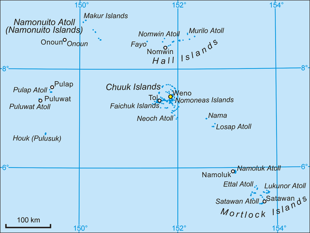
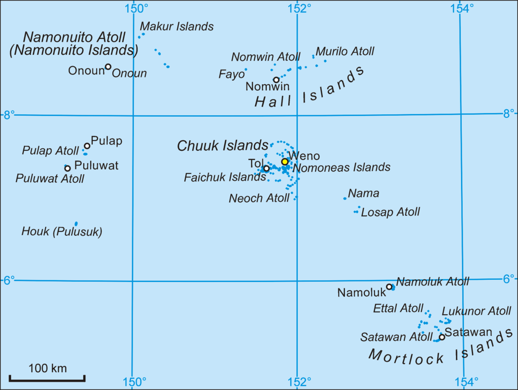
English: Map of Chuuk State, Micronesia.
Polski: Mapa stanu Chuuk w Mikronezji. |
| ရက်စွဲ | ၄ ဖေဖော်ဝါရီ ၂၀၀၆ (original upload date) |
| ရင်းမြစ် | Self-made and transferred from pl.wikipedia |
| စာရေးသူ | Aotearoa at ပိုလန် ဝီကီပီးဒီးယား |
လိုင်စင်သတ်မှတ်ခြင်း
| I, the copyright holder of this work, release this work into the public domain. This applies worldwide. In some countries this may not be legally possible; if so: အကျွန်ုပ်သည် ဤဖန်တီးမှုလက်ရာကို ဥပဒေအရလိုအပ်ခြင်းမရှိသည့် မည်သည့်အခြေအနေမျိုးတွက်မဆို၊ မည်သို့သော ရည်ရွယ်ချက်အတွက်မဆို ၎င်းကို မည်သူမဆို အသုံးပြုပိုင်ခွင့်အား ပေးအပ်သည်။ |
မူရင်းတင်ထားသောမှတ်တမ်း
ဖော်ပြချက် မူရင်းစာမျက်နှာမှာ here ဖြစ်သည်။ အောက်ပါအသုံးပြုသူ အမည်များအားလုံးသည် pl.wikipedia ကို ရည်ညွှန်းသည်။
- 2006-02-04 09:45 Aotearoa 1637×1231×8 (181692 bytes) Mapa stanu Chuuk w Mikronezji. Autor [[Wikipedysta:Aotearoa|Aotearoa]]
ဖိုင်မှတ်တမ်း
ဖိုင်ကို ယင်းနေ့စွဲ အတိုင်း မြင်နိုင်ရန် နေ့စွဲ/အချိန် တစ်ခုခုပေါ်တွင် ကလစ်နှိပ်ပါ။
| နေ့စွဲ/အချိန် | နမူနာပုံငယ် | မှတ်တမ်း ဒိုင်မန်းရှင်းများ | အသုံးပြုသူ | မှတ်ချက် | |
|---|---|---|---|---|---|
| ကာလပေါ် | ၀၆:၅၅၊ ၁၄ ဖေဖော်ဝါရီ ၂၀၀၆ | | ၁၆၃၇ × ၁၂၃၁ (၁၇၇ KB) | Aotearoa | Map of Chuuk State, Micronesia. Author: Aotearoa from Poland |
ဖိုင်သုံးစွဲမှု
အောက်ပါ စာမျက်နှာ သည် ဤဖိုင်ကို အသုံးပြုထားသည်:
ဂလိုဘယ် ဖိုင်သုံးစွဲမှု
အောက်ပါ အခြားဝီကီများတွင် ဤဖိုင်ကို အသုံးပြုထားသည်-
- ar.wikipedia.org တွင် အသုံးပြုမှု
- da.wikipedia.org တွင် အသုံးပြုမှု
- de.wikipedia.org တွင် အသုံးပြုမှု
- Föderierte Staaten von Mikronesien
- Mortlocks
- Chuuk (Bundesstaat)
- Mortlock Islands
- Losap
- Liste der Inseln der Föderierten Staaten von Mikronesien
- Hall Islands
- Oksoritod
- Vorlage:Infobox Verwaltungsgebiet (Insel)
- Vorlage:Infobox Verwaltungsgebiet (Insel)/Doku
- Nama (Insel)
- Etal (Atoll)
- Lukunor
- Pulap
- Houk (Insel)
- Fayu (Atoll)
- Nomwin
- Murilo
- James Mortlock
- en.wikipedia.org တွင် အသုံးပြုမှု
- es.wikipedia.org တွင် အသုံးပြုမှု
- fa.wikipedia.org တွင် အသုံးပြုမှု
- fi.wikipedia.org တွင် အသုံးပြုမှု
- fr.wikipedia.org တွင် အသုံးပြုမှု
- hr.wikipedia.org တွင် အသုံးပြုမှု
- id.wikipedia.org တွင် အသုံးပြုမှု
- it.wikipedia.org တွင် အသုံးပြုမှု
ဤဖိုင်ကို အခြားနေရာများတွင် အသုံးပြုထားမှုများအား ကြည့်ရှုရန်။